Holyoke, Colorado
| Holyoke, Colorado | |
|---|---|
| Home Rule Municipality | |
|
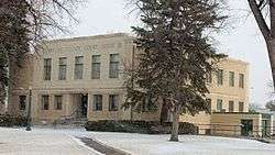
Phillips County Courthouse (2013) | |
| Motto: "It's not what you show, it's what you grow." | |
 Location within Phillips County and Colorado | |
| Coordinates: 40°34′55″N 102°18′4″W / 40.58194°N 102.30111°WCoordinates: 40°34′55″N 102°18′4″W / 40.58194°N 102.30111°W | |
| Country |
|
| State |
|
| County | Phillips[1] |
| Incorporated | May 31, 1888[2] |
| Government | |
| • Type | Home Rule Municipality[1] |
| Area | |
| • Total | 1.7 sq mi (4.5 km2) |
| • Land | 1.7 sq mi (4.5 km2) |
| • Water | 0 sq mi (0 km2) |
| Elevation[3] | 3,750 ft (1,143 m) |
| Population (2013) | |
| • Total | 1,965 |
| • Density | 1,200/sq mi (440/km2) |
| Time zone | MST (UTC-7) |
| • Summer (DST) | MDT (UTC-6) |
| ZIP code[4] | 80734 |
| Area code(s) | 970 |
| FIPS code | 08-37270 |
| GNIS feature ID | 0182823 |
| Website | Holyoke CoC |
Holyoke is the Home Rule Municipality that is the county seat and the most populous municipality of Phillips County, Colorado, United States.[5] The city population was 2,313 at the 2010 census.[6]
History
The city is named after Holyoke, Massachusetts.[7]
Geography
Holyoke is located at 40°34′55″N 102°18′4″W / 40.58194°N 102.30111°W (40.582002, -102.301056).[8] According to the United States Census Bureau, the city has a total area of 1.7 square miles (4.4 km2), all of it land.
|Feb high F = 51 |Mar high F = 56 |Apr high F = 59 |May high F = 69 |Jun high F = 77 |Jul high F = 92 |Aug high F = 96 |Sep high F = 83 |Oct high F = 70 |Nov high F = 47 |Dec high F = 39 |year high F = 63.8 |Jan low F = 22 |Feb low F = 30 |Mar low F = 33 |Apr low F = 41 |May low F = 52 |Jun low F = 55 |Jul low F = 60 |Aug low F = 66 |Sep low F = 55 |Oct low F = 44 |Nov low F = 31 |Dec low F = 19 |year low F = 36.2 |precipitation colour = green |Jan precipitation inch = 0.42 |Feb precipitation inch = 0.47 |Mar precipitation inch = 1.05 |Apr precipitation inch = 1.87 |May precipitation inch = 3.01 |Jun precipitation inch = 2.97 |Jul precipitation inch = 2.88 |Aug precipitation inch = 2.31 |Sep precipitation inch = 1.32 |Oct precipitation inch = 1.20 |Nov precipitation inch = 0.63 |Dec precipitation inch = 0.44 |year precipitation inch= 18.55 |Jan snow inch = 5.0 |Feb snow inch = 4.4 |Mar snow inch = 5.5 |Apr snow inch = 3.4 |May snow inch = 0.0 |Jun snow inch = 0.0 |Jul snow inch = 0.0 |Aug snow inch = 0.0 |Sep snow inch = 0.4 |Oct snow inch = 1.5 |Nov snow inch = 4.3 |Dec snow inch = 5.2 |year snow inch = 29.7 |source 1 = NOAA[9]
Demographics
| Historical population | |||
|---|---|---|---|
| Census | Pop. | %± | |
| 1890 | 649 | — | |
| 1900 | 451 | −30.5% | |
| 1910 | 659 | 46.1% | |
| 1920 | 1,205 | 82.9% | |
| 1930 | 1,226 | 1.7% | |
| 1940 | 1,150 | −6.2% | |
| 1950 | 1,558 | 35.5% | |
| 1960 | 1,555 | −0.2% | |
| 1970 | 1,640 | 5.5% | |
| 1980 | 2,092 | 27.6% | |
| 1990 | 1,931 | −7.7% | |
| 2000 | 2,261 | 17.1% | |
| 2010 | 2,313 | 2.3% | |
| Est. 2015 | 2,251 | [10] | −2.7% |
As of the census[12] of 2000, there were 2,261 people, 896 households, and 594 families residing in the city. The population density was 1,300.3 people per square mile (501.7/km²). There were 980 housing units at an average density of 563.6 per square mile (217.5/km²). The racial makeup of the city was 89.61% White, 0.04% African American, 0.31% Native American, 0.57% Asian, 8.09% from other races, and 1.37% from two or more races. Hispanic or Latino of any race were 20.39% of the population.
There were 896 households out of which 34.4% had children under the age of 18 living with them, 57.9% were married couples living together, 6.3% had a female householder with no husband present, and 33.7% were non-families. 30.6% of all households were made up of individuals and 16.0% had someone living alone who was 65 years of age or older. The average household size was 2.47 and the average family size was 3.11.
In the city the population was spread out with 28.3% under the age of 18, 6.4% from 18 to 24, 26.6% from 25 to 44, 20.1% from 45 to 64, and 18.7% who were 65 years of age or older. The median age was 38 years. For every 100 females there were 90.2 males. For every 100 females age 18 and over, there were 86.7 males.
The median income for a household in the city was $30,984, and the median income for a family was $36,970. Males had a median income of $30,500 versus $17,455 for females. The per capita income for the city was $15,697. About 12.0% of families and 14.6% of the population were below the poverty line, including 21.1% of those under age 18 and 8.4% of those age 65 or over.
See also
References
- 1 2 "Active Colorado Municipalities". State of Colorado, Department of Local Affairs. Retrieved 2007-09-01.
- ↑ "Colorado Municipal Incorporations". State of Colorado, Department of Personnel & Administration, Colorado State Archives. 2004-12-01. Retrieved 2007-09-02.
- ↑ "US Board on Geographic Names". United States Geological Survey. 2007-10-25. Retrieved 2008-01-31.
- ↑ "ZIP Code Lookup" (JavaScript/HTML). United States Postal Service. Retrieved October 6, 2007.
- ↑ "Find a County". National Association of Counties. Retrieved 2011-06-07.
- ↑ "2010 City Population and Housing Occupancy Status". U.S. Census Bureau. Retrieved June 7, 2012.
- ↑ Gannett, Henry (1905). The Origin of Certain Place Names in the United States. Govt. Print. Off. p. 159.
- ↑ "US Gazetteer files: 2010, 2000, and 1990". United States Census Bureau. 2011-02-12. Retrieved 2011-04-23.
- ↑ "NOWData - NOAA Online Weather Data". National Oceanic and Atmospheric Administration. Retrieved May 5, 2013.
- ↑ "Annual Estimates of the Resident Population for Incorporated Places: April 1, 2010 to July 1, 2015". Retrieved July 2, 2016.
- ↑ "Census of Population and Housing". Census.gov. Retrieved June 4, 2015.
- ↑ "American FactFinder". United States Census Bureau. Retrieved 2008-01-31.
External links
Municipalities and communities of Phillips County, Colorado, United States | ||
|---|---|---|
| City | 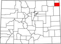 | |
| Towns | ||
| CDP | ||