Parts of Holland
| Lincolnshire, Parts of Holland | |
|---|---|
 | |
| Area | |
| • 1901 | 268,992 acres (1089 km²) |
| • 1961 | 267,847 acres (1083 km²) |
| Population | |
| • 1901 | 77,610 |
| • 1971 | 105,685 |
| History | |
| • Created | 1889 |
| • Abolished | 1974 |
| • Succeeded by | Lincolnshire |
| Status | Administrative county |
| • HQ | County Hall, Boston |
 | |
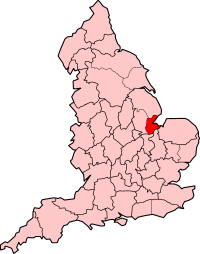
The Parts of Holland /ˈhɒlənd/ is a historical subdivision used in south-east Lincolnshire, England from 1889 to 1974.[1] The name is still recognised locally and survives in the district of South Holland.
Administration

Parts of Holland was one of the three medieval subdivisions or 'Parts' of Lincolnshire (the other two were Lindsey and Kesteven) which had long had separate county administrations (quarter sessions). Under the Local Government Act 1888 it obtained a county council, which it retained until 1974. At that point the three county councils were abolished and Lincolnshire (minus the northern part of Lindsey) had a single county council for the first time.
Before the changes of 1888, Holland had, since probably the tenth century, been divided into the three wapentakes of Elloe, Kirton and Skirbeck.[2]
Under the Local Government Act 1894 it was divided into rural districts, urban districts, with the municipal borough of Boston remaining untouched. The rural districts were Boston, Crowland, East Elloe and Spalding, whilst Holbeach, Long Sutton, Spalding and Sutton Bridge became urban districts. In 1932, the Crowland RD (which consisted of the single parish of Crowland) was abolished and added to Spalding RD, and all urban districts apart from Spalding were abolished and added to East Elloe Rural District.
Geography
The extent of Holland County Council (the pre-1974 county) was the same as that of the combined modern local government districts of Boston and South Holland.
Holland was all close to sea level, achieving a maximum altitude of about five metres (16 feet) on artificially raised river banks (levees). It therefore needed carefully managed drainage to maintain the very productive arable farmland which covered almost its entire extent. Consequently, a significant part of its drainage for arable use had to await the introduction of steam pumping. Before the mid nineteenth century, it was a much more pastoral area, used for fattening stock brought in from Scotland and northern England before it was driven to market in places like London. Many of the country roads are still called droves.
- Towns in Holland
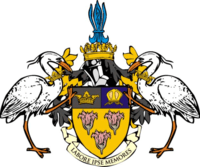
The motto shown on the coat of arms, Labor Ipse Memores, is incorrect and should read Labor Ipse Merces (work is its own reward). Examples may be seen in the window of the old hall (library) at Boston Grammar School, and on the wall of the dining room at Lincoln Hall, University of Nottingham.
There is a resemblance in landscape between the Parts of Holland and Holland, the region in the Netherlands, although their meanings are different. Holland in England means "land of the hill spurs", although hill spurs are hardly obvious, while the Dutch Holland is derived from the Middle Dutch term holtland ("wooded land"). Both Hollands have landscapes that are low lying and both are known for tulip growing.[3]
References
- ↑ "Parts of Holland (former division, England, United Kingdom) – Britannica Online Encyclopedia". britannica.com. 2012. Retrieved 5 April 2012.
- ↑ Lewis, Samuel (1848). "Skidbrook - Skutterskelfe | A Topographical Dictionary of England (pp. 115-118)". british-history.ac.uk. Retrieved 5 April 2012.
- ↑ Room, Adrian (1993). Dictionary of Place Names in the British Isles. Bloomsbury. p. 174. ISBN 0-7475-1511-5.
External links
- Map of Holland on Wikishire
- http://web.archive.org/web/20071001030631/http://www.visionofbritain.org.uk/relationships.jsp?u_id=10041806
Coordinates: 52°50′00″N 0°02′00″W / 52.8333°N 0.0333°W