Hole in the Rock Trail
|
Hole in the Rock Trail | |
|
The Hole in the Rock Trail passes between the Kaiparowits Plateau and the Escalante River | |
  | |
| Location | Garfield / Kane / San Juan counties, Utah, USA |
|---|---|
| Nearest city | Escalante, Utah |
| Coordinates | 37°43′39″N 111°31′53″W / 37.72750°N 111.53139°WCoordinates: 37°43′39″N 111°31′53″W / 37.72750°N 111.53139°W |
| Built | 1879 |
| NRHP Reference # | 82004792 |
| Added to NRHP | August 09, 1982[1] |
The Hole in the Rock Trail (often hyphenated as Hole-in-the-Rock) is a historic trail running east-southeast from the town of Escalante in southern Utah in the western United States. The Mormon trailblazers who established this trail crossed the Colorado River and ended their journey in the town of Bluff. The Hole-in-the-Rock expedition established the trail in 1879. The trail is located within the borders of the Grand Staircase-Escalante National Monument, the adjacent Glen Canyon National Recreation Area and federal Bureau of Land Management (BLM) public land to the east of the Colorado River. A geologic feature called the Hole in the Rock gave the trail its name. A modern unpaved road called the Hole-in-the-Rock Road (BLM Road 200) closely follows this historic trail to the point where it enters the Glen Canyon National Recreation Area. The modern road is an important access route for visiting the Canyons of the Escalante and the Devil's Garden. The trail is listed on the National Register of Historic Places, being added to that list in 1982.[1]
Route description
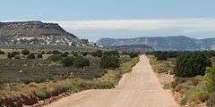
The trail follows a 180 miles (290 km) route starting near Escalante, Utah and ending in Bluff, Utah and is named for the place where the San Juan Mission of Mormon pioneers constructed a descent to the Colorado River. The natural crevice on the 1,000 feet (300 m) cliff above the Colorado was enlarged by the party to lower the wagons down to river level, where it could be forded. The portion of the trail below the Hole-In-The-Rock is now flooded by Lake Powell. After the river crossing the trail continued past the Register Rocks, where the settlers recorded their names, now covered by the lake. The road rises through the Chute and across slickrock sandstone to Grey Mesa. Another difficult descent was required from Grey Mesa, requiring the party to cut a road from one ledge to another on the face of the mesa, taking a week. Another week was spent in constructing a road down Clay Hill Pass. Further on, blocked by Comb Ridge, the trail follows Comb Wash to San Juan Hill, where yet another road was built up the hill. The trail ends in Bluff.[2]
-
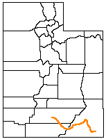
Entire trail - Escalante (left) to Bluff (right)
-
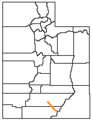
Current Hole-in-the-Rock Road - Escalante to the Hole-in-the-Rock
Gallery
-

Metate Arch in Devil's Garden
-
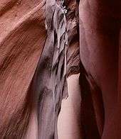
Peek-a-Boo Gulch
-
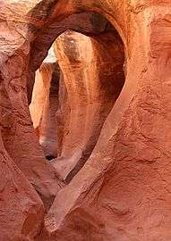
Spooky Gulch
-

Hole-in-the-Rock, looking down at Lake Powell
References
- 1 2 National Park Service (2009-03-13). "National Register Information System". National Register of Historic Places. National Park Service.
- ↑ Powell, A. Kent (January 1979). "National Register of Historic Places Inventory - Nomination Form: Hole-In-The-Rock Trail" (PDF). National Park Service. Retrieved 2009-06-18.
External links
- Hole-in-the Rock, Glen Canyon National Recreation Area, U.S. National Park Service
- TopoQuest Map
- Photographs of the Hole in the Rock Trail at the National Park Service's NRHP database
- Historic American Engineering Record (HAER) No. UT-29, "Hole-in-the-Rock Trail, Running From Bluff Vicinity to Escalante, Garfield County, Bluff, San Juan County, UT", 8 photos, 4 data pages
| Topics | |
|---|---|
| Lists by states |
|
| Lists by insular areas | |
| Lists by associated states | |
| Other areas | |
| |