Holborn
| Holborn | |
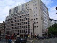
 Holborn Bars, built 1879–1901, headquarters of Prudential Assurance, at 138–142 Holborn |
|
 Holborn |
|
| Population | 13,023 (2011 Census. Holborn and Covent Garden Ward)[1] |
|---|---|
| OS grid reference | TQ305815 |
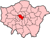
| London borough | Camden |
| Ceremonial county | Greater London |
| Region | London |
| Country | England |
| Sovereign state | United Kingdom |
| Post town | LONDON |
| Postcode district | WC1, WC2 |
| Postcode district | EC1 |
| Dialling code | 020 |
| Police | Metropolitan |
| Fire | London |
| Ambulance | London |
| EU Parliament | London |
| UK Parliament | Holborn and St Pancras |
| Cities of London and Westminster | |
| London Assembly | Barnet and Camden |
| City and East | |
Coordinates: 51°31′02″N 0°07′06″W / 51.5172°N 0.1182°W
Holborn (/ˈhoʊbərn/ HOH-bə(r)n)[a] is a district in the West End, central London, forming part of the London Borough of Camden.
History
Toponymy
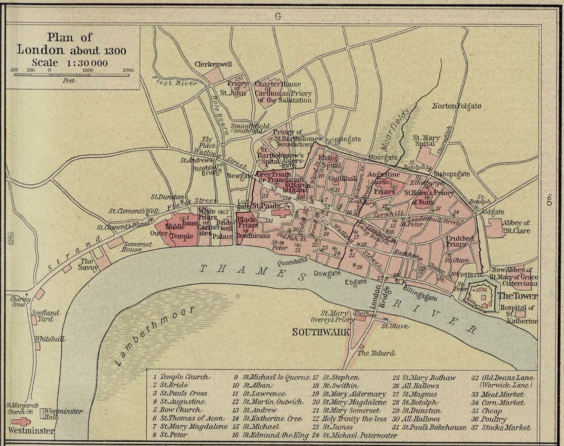
The area's first mention is in a charter of Westminster Abbey, by King Edgar, dated to 959. This mentions "the old wooden church of St Andrew" (St Andrew, Holborn).[2] The name Holborn may be derived from the Middle English "hol" for hollow, and bourne, a brook, referring to the River Fleet as it ran through a steep valley to the east.[2][3] Historical cartographer William Shepherd in his Plan of London about 1300 labels the Fleet as "Hole Bourn" where it passes to the east of St Andrew's church.[4] However, the 16th century historian John Stow attributes the name to the Old Bourne ("old brook"), a small stream which he believed ran into the Fleet at Holborn Bridge, a structure lost when the river was culverted in 1732. The exact course of the stream is uncertain, but according to Stow it started in one of the many small springs near Holborn Bar, the old City toll gate on the summit of Holborn Hill.[3][5] This is supported by a map of London and Westminster created during the reign of Henry VIII that clearly marks the street as 'Oldbourne' and 'High Oldbourne'.[6] Other historians, however, find the theory implausible, in view of the slope of the land.[7]
Local governance
It was then outside the City's jurisdiction and a part of Ossulstone Hundred in Middlesex. In the 12th century St Andrew's was noted in local title deeds as lying on "Holburnestrate"—Holborn Street.[8] The original Bars were the boundary of the City of London from 1223, when the City's jurisdiction was extended beyond the Walls, at Newgate, into the suburb here, as far as the point where the Bars were erected, until 1994 when the border moved to the junction of Chancery Lane. In 1394 the Ward of Farringdon Without was created, but only the south side of Holborn was under its jurisdiction with some minor properties, such as parts of Furnival's Inn, on the northern side, "above Bars". The rest of the area "below Bars" (outside the City's jurisdiction) was organised by the vestry board of the parish of St Andrew.[9] The St George the Martyr Queen Square area became a separate parish in 1723 and was combined with the part of St Andrew outside the City of London in 1767 to form St Andrew Holborn Above the Bars with St George the Martyr.
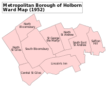
The Holborn District was created in 1855, consisting of the civil parishes and extra-parochial places of Glasshouse Yard, Saffron Hill, Hatton Garden, Ely Rents and Ely Place, St Andrew Holborn Above the Bars with St George the Martyr and St Sepulchre. The Metropolitan Borough of Holborn was created in 1900, consisting of the former area of the Holborn District and the St Giles District, excluding Glasshouse Yard and St Sepulchre, which went to the Metropolitan Borough of Finsbury. The Metropolitan Borough of Holborn was abolished in 1965 and its area now forms part of the London Borough of Camden.
Local politicians include Keir Starmer MP, the Labour Party Member of Parliament for Holborn and St Pancras, and Mark Field MP of the Conservative Party Member of Parliament, who is MP of the City of London portion of Holborn, part of the Cities of London and Westminster and three ward councillors for Holborn and Covent Garden: Cllr Julian Fulbrook, Cllr Sue Vincent and Cllr Awale Olad of the Labour Party. Holborn is also represented in the London Assembly as part of Barnet and Camden by Andrew Dismore, also of the Labour Party.
Urban development
In the 18th century, Holborn was the location of the infamous Mother Clap's molly house but in the modern era High Holborn has become a centre for entertainment venues to suit more general tastes: 22 inns or taverns were recorded in the 1860s and the Holborn Empire, originally Weston's Music Hall, stood between 1857 and 1960, when it was pulled down after structural damage sustained in the Blitz. The theatre premièred the first full-length feature film in 1914, The World, the Flesh and the Devil, a 50-minute melodrama filmed in Kinemacolour.[10]
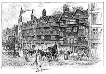
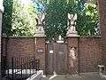
Charles Dickens took up residence in Furnival's Inn, on the site of "Holborn Bars" (the former Prudential building designed by Alfred Waterhouse). Dickens put his character "Pip", in Great Expectations, in residence at Barnard's Inn opposite, now occupied by Gresham College.[11] Staple Inn, notable as the promotional image for Old Holborn tobacco,[12] is nearby. The three of these were Inns of Chancery. The most northerly of the Inns of Court, Gray's Inn, is in Holborn, as is Lincoln's Inn: the area has been associated with the legal professions since mediaeval times, and the name of the local militia (now Territorial Army unit, the Inns of Court & City Yeomanry) still reflects that. Subsequently, the area diversified and become recognisable as the modern street. A plaque stands at number 120 commemorating Thomas Earnshaw's invention of the Marine chronometer, which facilitated long-distance travel. At the corner of Hatton Garden was the old family department store of Gamages. Until 1992, the London Weather Centre was located in the street. The Prudential insurance company relocated in 2002. The Daily Mirror offices used to be directly opposite it, but the site is now occupied by Sainsbury's head office.
Modern times
Further east, in the gated avenue of Ely Place, is St Etheldreda's Church, originally the chapel of the Bishop of Ely’s London palace. This ecclesiastical connection allowed the street to remain part of the county of Cambridgeshire until the mid-1930s. This meant that Ye Olde Mitre, a pub located in a court hidden behind the buildings of the Place and the Garden was subject to the Cambridgeshire Magistrates to grant its licence.[13][14] St Etheldreda's is the oldest church building used for Roman Catholic worship in London. However, this became so only after it ceased to be an Anglican chapel in the 19th century.
Hatton Garden, the centre of the diamond trade, was leased to a favourite of Queen Elizabeth I, Sir Christopher Hatton, at the insistence of the Queen to provide him with an income. Behind the Prudential Building lies the Anglo-Catholic church of St Alban the Martyr.[15] Originally built in 1863 by architect William Butterfield, it was gutted during the Blitz but later reconstructed, retaining Butterfield's west front. The current vicar is the Rev. Christopher Smith.[15] On the southern side lie Chancery Lane and Fetter Lane.
On Holborn Circus lies the Church of St Andrew, an ancient Guild Church that survived the Great Fire of London. However the parochial authority decided to commission Sir Christopher Wren to rebuild it. Although the nave was destroyed in the Blitz, the reconstruction was faithful to Wren's original. In the middle of the Circus there is a large equestrian statue of Prince Albert by Charles Bacon (1874), the City's official monument to him. It was presented by Charles Oppenheim, of the Diamond Trading Company De Beers, whose headquarters building is in nearby Charterhouse Street.

In the early 21st century, Holborn has become the site of new offices and hotels: for example, the old neoclassical Pearl Assurance building near the junction with Kingsway was converted into a hotel in 1999.
There has been a limited attempt to rebrand Holborn (and perhaps other nearby areas such as Bloomsbury) as "Midtown", on the grounds that it is notionally in the very middle of London, between the West End and the City (often considered, such as for postcode purposes, to be on the east side of central London).[16] The rebrand attempt may arise from the fact that, despite its central location, Holborn is relatively less well-known than the West End and the City.
Education
- For education within the Westminster portion of Holborn see the main City of Westminster article.
Geography
Nearby areas
Transport
The nearest London Underground stations are Chancery Lane and Holborn. The closest mainline railway station is City Thameslink.
Notable people
The following is a list of notable people who were born in or are significantly connected with Holborn.
- John Barbirolli, conductor, was born in Southampton Row (blue plaque on hotel his father managed).
- Thomas Chatterton (1752–1770), poet, was born in Bristol and died in a garret in Holborn at the age of 17.
- Samuel Coleridge-Taylor (1875–1912), composer, born at 15 Theobalds Road; acclaimed especially for The Song of Hiawatha trilogy.
- Charles Dickens lived in Doughty Street where there is a museum.
- Naomi Lewis (1911–2009), advocate of animal rights, poet, children's author and teacher, lived in Red Lion Square 1935–2009.
- Eric Morley (1918–2000), founder of Miss World pageant, was born in Holborn.
- Ann Radcliffe (1764–1823), novelist and renowned author of the Gothic novel, was born in Holborn.
- John Shaw, Jr. (1803–1870), architect, was born in Holborn; praised as a designer in the "Manner of Wren".
- Barry Sheene (1950–2003), World Champion motorcycle racer, spent his early years in Holborn.
- William Morris (1845–1896), artist and socialist lived at 8 Red Lion Square.
Gallery
 The headquarters of Sainsbury's at Holborn Circus
 Grange Holborn Hotel
 Entrance to Gray's Inn
 Royal London Fusiliers Monument on Holborn, dedicated to those who died in World War I
See also
-
 London portal
Notes
- a. ^ Pronunciation: The authoritative BBC pronunciation unit recommends "ˈhəʊbə(r)n", but allowing "sometimes also hohl-buhrn". The organisation's less formal Pronouncing British Placenames notes that "You'll occasionally find towns where nobody can agree...Holborn in central London has for many years been pronounced 'hoe-bun', but having so few local residents to preserve this, it's rapidly changing to a more natural 'hol-burn'".[17][18] However, Modern British and American English pronunciation (2008) cites "Holborn" as one of its examples of a common word where the "l" is silent.[19] The popular tourist guide The Rough Guide to Britain sticks to the traditional form, with neither "l" nor "r": /ˈhoʊbən/ HOH-bən.[20]
References
- ↑ "Camden Ward population 2011". Neighbourhood Statistics. Office for National Statistics. Retrieved 20 October 2016.
- 1 2 Lethaby, William (1902). London before the conquest. London: Macmillan. p. 60.
- 1 2 Besant, Walter; Mitton, Geraldine (1903). Holborn and Bloomsbury. The Fascination of London (Project Gutenberg, 2007 ed.). London: Adam and Charles Black. Retrieved 13 August 2008.
- ↑ Shepherd, William R (1926). Historical atlas (3 ed.). University of London. p. 75. OCLC 253088196.
- ↑ Strype, John (1720). "Rivers and other Waters serving this City". Survey of London. The Stuart London Project. Online edition: University of Sheffield 2007.
- ↑ http://www.oldlondonmaps.com/oldenmappages/olden08a.html
- ↑ Lethaby (1902:48)
- ↑ Harben, Henry (1918). A Dictionary of London. London: Herbert Jenkins.
- ↑ The Parish of St Andrew Holborn pp11-12 Caroline Barron London 1979
- ↑ The World, the Flesh and the Devil at the Internet Movie Database
- ↑ Chap. 20
- ↑ Hibbert, Christopher; et al. (1983). The London Encyclopedia (2010 ed.). London: MacMillan. p. 397. ISBN 1-4050-4925-1.
- ↑ Vitaliev, Vitali (3 January 2003). "Things that go bump on the map". The Daily Telegraph. Retrieved 12 August 2008.
- ↑ Hammond, Derek (28 June 2006). "Secret London: Ye Olde Mitre Tavern". Time Out. Retrieved 12 August 2008.
- 1 2 St Alban the Martyr accessed 14 December 2013
- ↑ http://www.telegraph.co.uk/history/9359556/A-Midtown-inLondon-Theres-NoHo-chance.html
- ↑ Olausson, Lena (2006). "Holborn". Oxford BBC Guide to Pronunciation, The Essential Handbook of the Spoken Word (3rd ed.). Oxford, England: Oxford University Press. p. 173. ISBN 0-19-280710-2.
- ↑ "Pronouncing British Placenames". BBC. 7 March 2007. Retrieved 21 November 2009.
- ↑ Dretzke, Burkhard (2008). Modern British and American English pronunciation. Paderborn, Germany: Ferdinand Schöningh. p. 63. ISBN 3-8252-2053-2.
- ↑ Roberts, Andrew; Matthew Teller (2004). The Rough Guide to Britain. London: Rough Guides Ltd. p. 109. ISBN 1-84353-301-4.
External links
- Holborn and Bloomsbury, by Sir Walter Besant and Geraldine Edith Mitton, 1903, from Project Gutenberg