Holbeck
| Holbeck | |
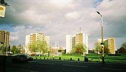 View of Holbeck Moor with Bridgewater Place in the background |
|
 Holbeck |
|
| Population | 5,505 |
|---|---|
| OS grid reference | SE311314 |
| Metropolitan borough | City of Leeds |
| Metropolitan county | West Yorkshire |
| Region | Yorkshire and the Humber |
| Country | England |
| Sovereign state | United Kingdom |
| Post town | LEEDS |
| Postcode district | LS11 |
| Dialling code | 0113 |
| Police | West Yorkshire |
| Fire | West Yorkshire |
| Ambulance | Yorkshire |
| EU Parliament | Yorkshire and the Humber |
| UK Parliament | Leeds Central |
Coordinates: 53°47′20″N 1°33′18″W / 53.789°N 1.555°W
Holbeck (grid reference SE311314) is a district in Leeds, West Yorkshire, England.
The district begins on the southern edge of the Leeds city centre and mainly lies in the LS11 Leeds postcode area. The M1 and M621 motorways used to end/begin in Holbeck. Now the M621 is the only motorway that passes through the area since the end of the M1 moved to Hook Moor near Aberford. Since large parts of Holbeck have been vacated in preparation for the regeneration of the area, the district has in large parts suffered from a population exodus. Holbeck had a population of 5,505 in 2011.[1][2] The district currently falls within the Beeston and Holbeck ward of the Leeds City Council.
The Leeds and Liverpool Canal also runs through Holbeck.
History


The place-name Holbeck is first attested in the 12th century in forms such as Holebec and Holesbec, from hol 'a hollow' and beck 'a stream' (an Old Norse loanword, from bekkr, reflecting Scandinavian influence in Yorkshire during the Viking age), thus 'stream in the hollow'.[3] The old manor belonged to the priory of the Holy Trinity at York and after the Dissolution of the Monasteries passed to the Darcy and Ingram families.[4] In the 18th century Holbeck was known for its spa water, which resembled that of Harrogate, and was carried into Leeds for sale. The supply diminished when numerous wells were sunk to supply the mills and works in the area and the water, which previously rose to the surface, could only be obtained by pumping from a considerable depth.[4]
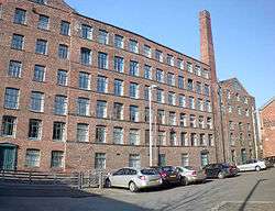
In the first half of the 19th century Holbeck village was a hamlet of few streets, most were owned by John Scholey (1774–1834) and are listed in his will at the Borthwick Institute for Archives, University of York. His family sold the properties at the beginning of the Industrial Revolution. The area became industrial and several mills including John Marshall's Mill were built to spin flax and thread. Marshall's Mill consisted of a spacious room lit by skylights, occupying an area of nearly two acres. There were ironworks, works for the manufacture of steam engines and machinery of all kinds.[4] Matthew Murray's Round Foundry on Water Lane was where the Middleton Railway's first steam locomotives were built. The factory in Silver Street belonging to Taylor, Wordsworth and Co, machine makers, eventually grew to cover three acres. In the mid 19th century Holbeck was one of the most densely populated suburbs of Leeds. Colonel Thomas Harding was another industrialist with works in the area.[5] By 1834 Holbeck was "the most crowded, most filthy and unhealthy village in the country." Slum clearance began by 1900.[6]
Holbeck has suffered significant decline since the 19th century; many of the industrial buildings and warehouses have been demolished or fallen into disrepair. Holbeck is nevertheless home to 33 listed buildings and many other important architectural structures, some of the most notable of these are: The Dark Arches, the Hol Beck, Marshall's Mill, the Midland Mills, the Round Foundry, Temple Works, Tower Works and two railway roundhouses.[5]
Holbeck was once well served by rail; Holbeck railway station (now demolished) was notable because it was a two-tier station with a low line and a high line. A disused railway viaduct still runs through Holbeck. When it was built in 1869, it was thought to be one of the engineering marvels of the Victorian age. Plans are now underway to convert the track bed (which is currently overgrown with trees and shrubs) into a raised walkway leading directly into Leeds city centre.[7]
Recent times
From 1956 to 2004 Kays Catalogues was the largest employer in Holbeck and had a distribution centre on Marshall Street. Kay's acquired Samuel Driver Ltd in 1956 and took over its Holbeck depot. Part of the Kay's premises is a listed building.[8]
Hasib Hussain, the suicide bomber responsible for the Tavistock Square bus bombing in London on 7 July 2005, lived in Holbeck.[9]
Geography
The name Holbeck derives its name from the brook on which it is situated. Since industrialisation the beck, a natural watercourse has been canalised with stone-set floor and stone walls. It is crossed by several bridges giving access from Water Lane. Holbeck is on the flood plain on the south side of the River Aire of which the Hol Beck is a tributary.[5]
It covers an area of about 553 acres.[4] The Leeds and Liverpool Canal runs parallel to the river on its south side.
Regeneration
Over recent years efforts have been made to regenerate the Holbeck area. The most notable scheme is the Holbeck Urban Village, which is expected to attract investment of around £800 million and create around 5,000 jobs. However, the area surrounding the 'Village' is deprived and run down. From 2007, Leeds City Council began vacating the back-to-back housing and in 2010 began demolition.
Landmarks
The Holbeck Conservation Area includes several industrial archaeological sites and Listed buildings. Holbeck is unique in Leeds as an area where many early to mid 19th century industrial buildings survive in an unaltered group within the original street pattern. The buildings are utilitarian two or three-storey brick structures with some larger complexes such as Temple Mill and the brick terracotta towers of Tower Works. Railway viaducts cut through the area, notably that of the Leeds and Bradford Railway of 1846 and the London and North Western Railway's extension line of 1882.[5] Holbeck Public Library is built in red brick and terracotta.[10]
Religion
The old chapel, dedicated to St. Catherine and recorded in ancient documents as existing in 809, was rebuilt on the same site in the early 18th century. It became inadequate for the rapidly increasing population at that time and was demolished in 1836. The church of St. Matthew was built on common land next to the old burial-ground. It cost £3,786 and was a Commissioners' church built by the Parliamentary Commissioners and consecrated in 1832. It is built in the early English style. There were places of worship for Independents, Wesleyans and other denominations.[4] Currently the groups that meet in Holbeck include the Holbeck Christian Fellowship and Mosaic Church which is found on Sweet Street in a warehouse opposite the Commercial pub has been in Holbeck since early 2008. Over the last few years several of Mosaic's Church attendees have moved into Holbeck.
Amenities
The area has lost amenities as part of the population exodus connected with the demolition of properties as part of the regeneration scheme. Kwik Save supermarket closed in 2005, leaving small independent convenience stores. The post office closed in 2008, but reopened in 2009. There is a bookmaker and several fast food takeaways.
Red Light District
In 2014 Leeds Council in conjunction with West Yorkshire Police trialled the first UK-based managed red-light district to the area between the hours of 7 am to 7 pm after the failing of police efforts to control prostitution in the area.[11] After a review in 2016 it was announced that this was to continue indefinitely.
References
- ↑ Holbeck is made up of 21 Output areas in the Beeston and Holbeck ward http://ukcensusdata.com/beeston-and-holbeck-e05001415#sthash.izecXSHH.dpbs
- ↑ Holbeck is also made up of 2 output areas in the City and Hunslet ward in the centre of Leeds http://ukcensusdata.com/city-and-hunslet-e05001420#sthash.uqs192IK.dpbs
- ↑ A. H. Smith, The Place-Names of the West Riding of Yorkshire, English Place-Names Society, 30–37, 8 vols (Cambridge: Cambridge University Press, 1961–63), III 216.
- 1 2 3 4 5 Lewis, Samuel (1848), "Holbeck", A Topographical Dictionary of England, British History Online, pp. 524–527, retrieved 24 September 2010
- 1 2 3 4 "Holbeck Conservation Area Appraisal" (PDF). Leeds Council. Retrieved 24 September 2010.
- ↑ Leach & Pevsner 2009, p. 553
- ↑ Brown, Jonathan. "Leeds skywalk pipedream is on way to being revived". Yorkshire Evening Post. Retrieved 10 February 2014.
- ↑ Kays Heritage Group
- ↑ "Profile: Hasib Hussain". BBC. 2 March 2011. Retrieved 3 December 2015.
- ↑ Leach & Pevsner 2009, p. 554
- ↑ "Leeds red-light district made permanent fixture with 'prostitution zone' three weeks after sex worker murder". Telegraph.co.uk. Retrieved 12 November 2016.
Bibliography
- Leach, Peter; Pevsner, Nikolaus (2009), The Buildings of England: Yorkshire West Riding, Leeds, Bradford and the North, New Haven and London: Yale University Press, ISBN 978-0-300-12665-5
External links
| Wikimedia Commons has media related to Holbeck. |
- Holbeck Urban Village
- Where I Live - Holbeck BBC Leeds Mini Guides
- The ancient parish of Leeds: historical and genealogical information at GENUKI (Holbeck was in this parish).