Hohberghorn
Not to be confused with Höhberghorn.
| Hohberghorn | |
|---|---|
|
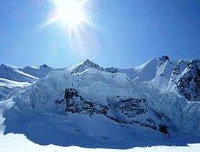
The Hohberghorn (right), with the Stecknadelhorn (centre) and the Nadelhorn (left), from the north side | |
| Highest point | |
| Elevation | 4,219 m (13,842 ft) |
| Prominence | 75 m (246 ft) [1] |
| Isolation | 0.4 kilometres (0.25 mi) |
| Parent peak | Nadelhorn |
| Coordinates | 46°06′45.7″N 7°51′13.9″E / 46.112694°N 7.853861°ECoordinates: 46°06′45.7″N 7°51′13.9″E / 46.112694°N 7.853861°E |
| Geography | |
 Hohberghorn Location in Switzerland | |
| Location | Valais, Switzerland |
| Parent range | Pennine Alps |
| Climbing | |
| First ascent | August 1869 by R. B. Heathcote, Franz Biner, Peter Perren and Peter Taugwalder |
| Easiest route | Basic snow climb |
The Hohberghorn (4,219 m) is a mountain in the Pennine Alps in Switzerland. It lies towards the northern end of the Nadelgrat, a high-level ridge running roughly north–south, north of the Dom, above the resort of Saas-Fee to the east, and the Mattertal to the west.
It was first climbed by R. B. Heathcote, with guides Franz Biner, Peter Perren and Peter Taugwalder on, in August 1869 via the west gully above the Hohberg Glacier to the Stecknadeljoch.
Its north-east face, not as long or as steep as that on the neighbouring Lenzspitze, is 320 m and at an average angle of 50 degrees, and might be considered as excellent training for the latter.[2]
References
- Dumler, Helmut and Willi P. Burkhardt, The High Mountains of the Alps, London: Diadem, 1994
External links
- "Hohberghorn". SummitPost.org.
- "The Nadelgrat". SummitPost.org
- Hohberghorn on Hikr
This article is issued from Wikipedia - version of the 1/24/2016. The text is available under the Creative Commons Attribution/Share Alike but additional terms may apply for the media files.