Hodonín
- See other places named Hodonín.
| Hodonín | |||
| Town | |||
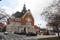 Town hall | |||
|
|||
| Country | Czech Republic | ||
|---|---|---|---|
| Region | South Moravian | ||
| District | Hodonín | ||
| Commune | Hodonín | ||
| Elevation | 167 m (548 ft) | ||
| Coordinates | CZ 48°50′56.17″N 17°7′56″E / 48.8489361°N 17.13222°ECoordinates: CZ 48°50′56.17″N 17°7′56″E / 48.8489361°N 17.13222°E | ||
| Area | 63.05 km2 (24.34 sq mi) | ||
| Population | 24,975 (1.1.2015) | ||
| Density | 396/km2 (1,026/sq mi) | ||
| Founded | 11th century | ||
| Mayor | Milan Lúčka | ||
| Timezone | CET (UTC+1) | ||
| - summer (DST) | CEST (UTC+2) | ||
| Postal code | 695 01 | ||
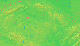  Location in the Czech Republic | |||
| Wikimedia Commons: Hodonín | |||
| Statistics: statnisprava.cz | |||
| Website: Hodonin.eu | |||


Hodonín (Czech pronunciation: [ˈɦodoɲiːn]; German: Göding) is a town on the River Morava in the southeast of Moravia, in the Czech Republic. It lies in the South Moravian Region. The population is 25,479 (2011).
Hodonín was first mentioned in 1046. In 1228 it became a town. In 1850 Tomáš Garrigue Masaryk, the first president of independent Czechoslovakia, was born there.
In the vicinity of the town there is an oil field and a stratum of lignite, which was formerly transported to the town of Otrokovice, a few kilometers from the city of Zlín, by a special water channel known as the Baťův kanál. It was built by the famous Czech entrepreneur Tomáš Baťa and now operates as a tourist attraction.
Demography
| 1890 | 7 616 |
| 1900 | 9 018 |
| 1921 | 13 200 |
| 1930 | 14 882 |
| 1950 | 13 572 |
| 1970 | 20 829 |
| 1980 | 25 485 |
| 1991 | 28 230 |
| 2001 | 27 361 |
| 2006 | 26 226 |
| 2011 | 25 479 |
Twin towns
Hodonín is twinned with:
References
- Notes
- ↑ "Cattolica Official Website – (Cattolica's Twin Towns)".
 (in Italian).
 - ↑ "Jasło Official Website – "Współpraca Międzynarodowa Jasła" (Jasło's Twin Towns)".
 (in Polish) [[copyright|]] 2008 Urząd Miasta w Jaśle. Retrieved 2008-10-23.
External links
- Municipal website (Czech)
This article is issued from Wikipedia - version of the 5/19/2016. The text is available under the Creative Commons Attribution/Share Alike but additional terms may apply for the media files.