Hobarrow Bay
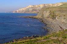
Hobarrow Bay is a small secluded southwest-facing bay, with an oil shale and shingle beach to the southeast of Brandy Bay and to the southwest of Kimmeridge on the south coast of the Isle of Purbeck, in Dorset, England.
Location
Hobarrow Bay is located just over 1 kilometre (0.62 mi) southeast of the ghost village of Tyneham, about 6 kilometres (3.7 mi) south of Wareham and about 15 kilometres (9.3 mi) west of Swanage. It is part of the Jurassic Coast.[1]
Access to Hobarrow Bay is possible solely by foot from the South West Coast Path via Kimmeridge, but admission to the Bay is prohibited. The area around the Bay is owned by the Ministry of Defence (MoD). Lulworth Ranges are part of the Armoured Fighting Vehicles Gunnery School. The ranges, which are more than 2,830 hectares (7,000 acres),[2] lie within an Area of Outstanding Natural Beauty and stretche along the coastline between Lulworth Cove to just west of Kimmeridge. Because tanks and armoured vehicles are used in this area, safety warnings about explosives and unexploded shells are posted around the area by the MoD, and visitors are advised to keep to official footpaths and abide by local site notices.[3]
See also
References
- ↑ "Dorset and East Devon Coast". UNESCO World Heritage Centre. 2001. Retrieved 2010-11-16.
- ↑ "Public access to military areas". web page. Ministry of Defence. 12 December 2012. Retrieved 19 December 2012.
- ↑ Ministry of Defence (2003). "Safety and access restrictions: Lulworth ranges". Ministry of Defence. Retrieved 2010-11-16.
Coordinates: 50°36′40″N 2°08′55″W / 50.61100°N 2.14860°W