History of local government in Wales
The history of local government Wales in a recognisably modern form emerged during the late 19th century.
Local Government Act 1888
From 1889 to 1974, counties made up of administrative counties and county boroughs were used for local government purposes. The counties were created by the Local Government Act 1888 (51 & 52 Vict, c. 41) based on the historic counties of Wales, but they were not entirely identical.
Administrative counties

The table shows the area and population of administrative counties in Wales as recorded at the censuses of 1891 and 1961.[1][2]
| Administrative county | Area 1891 (Statute acres) |
Population 1891 | Area 1961 (Statute acres) |
Population 1961 |
|---|---|---|---|---|
| Anglesey | 175,836 | 50,098 | 176,694 | 51,705 |
| Brecknockshire | 469,894 | 51,393 | 469,281 | 55,185 |
| Cardiganshire | 443,071 | 63,467 | 443,189 | 53,648 |
| Carmarthenshire | 587,816 | 130,566 | 588,271 | 168,008 |
| Caernarfonshire(1) | 360,138 | 117,233 | 364,108 | 121,767 |
| Denbighshire | 424,235 | 118,843 | 427,978 | 174,151 |
| Flintshire | 164,051 | 77,277 | 163,707 | 150,082 |
| Glamorgan | 505,815 | 467,954 | 468,808 | 523,253 |
| Merionethshire | 427,810 | 49,212 | 422,372 | 38,310 |
| Monmouthshire | 342,548 | 203,347 | 346,779 | 336,556 |
| Montgomeryshire | 510,111 | 58,003 | 510,110 | 41,165 |
| Pembrokeshire | 392,710 | 88,296 | 393,008 | 94,124 |
| Radnorshire | 301,164 | 21,791 | 301,165 | 18,471 |
(1)Renamed from Carnarvonshire, 1 July 1926[3]
County boroughs
There were also a number of administratively independent county boroughs:
- Cardiff created in 1889 (associated with Glamorgan)
- Swansea, created in 1889 (associated with Glamorgan)
- Newport, separated from Monmouthshire in 1891
- Merthyr Tydfil, separated from Glamorgan in 1908
| County borough | Area 1911 (Statute acres) |
Population 1911 | Area 1961 (Statute acres) |
Population 1961 |
|---|---|---|---|---|
| Cardiff | 6,373 | 182,259 | 15,085 | 256,582 |
| Merthyr Tydfil | 17,761 | 80,990 | 17,760 | 59,039 |
| Newport | 4,504 | 83,691 | 7,691 | 112,298 |
| Swansea | 5,202 | 114,663 | 21,600 | 167,322 |
Local Government Act 1972: Counties and districts
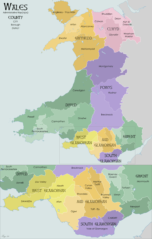
In 1974, the existing administrative counties and county boroughs were abolished and replaced by eight new two-tier authorities, instead called 'counties' by the Local Government Act 1972 (1972 c. 70). These counties were sub-divided into lower-tier districts.
The counties were all given names in Welsh only, apart from the three in Glamorgan, which had English names as well as Welsh. The creation of these new administrative areas effectively separated the administrative function from the traditional counties, although in reality this had occurred in 1889.
When these two-tier counties were abolished in 1996, their names and areas were retained with slight modifications for some purposes such as Lieutenancy, and became known as the preserved counties of Wales. These were further amended in 2003 by S.I. 2003/974 to ensure that each unitary area is wholly within one preserved county.
Counties
- Gwent
- South Glamorgan
(De Morgannwg) - Mid Glamorgan
(Morgannwg Ganol) - West Glamorgan
(Gorllewin Morgannwg) - Dyfed
- Powys
- Gwynedd
- Clwyd
Districts
The counties were sub-divided into districts, these were:
- Clwyd — Alyn and Deeside, Colwyn, Delyn, Glyndwr, Rhuddlan, Wrexham Maelor
- Dyfed — Carmarthen, Ceredigion, Dinefwr, Llanelli, Preseli Pembrokeshire (named Preseli until 1987), South Pembrokeshire
- Gwent — Blaenau Gwent, Islwyn, Monmouth, Newport, Torfaen
- Gwynedd — Aberconwy, Arfon, Dwyfor, Meirionnydd, Anglesey
- Mid Glamorgan — Cynon Valley, Ogwr, Merthyr Tydfil, Rhondda, Rhymney Valley, Taff–Ely
- Powys — Brecknock, Montgomery, Radnor
- South Glamorgan — Cardiff, Vale of Glamorgan
- West Glamorgan — Lliw Valley, Neath, Port Talbot (named Afan until 1986), Swansea
1996
The redistribution of these districts into the current unitary authorities is as follows:
| Unitary authority | Previous districts |
|---|---|
| Blaenau Gwent | most of Blaenau Gwent |
| Bridgend | most of Ogwr |
| Caerphilly | Islwyn, Rhymney Valley |
| Carmarthenshire | Carmarthen, Llanelli, Dinefwr |
| Cardiff | Cardiff, part of Taff–Ely |
| Ceredigion | Ceredigion |
| Conwy | Aberconwy, most of Colwyn |
| Denbighshire | Rhuddlan, parts of Glyndwr and Colwyn |
| Flintshire | Alyn and Deeside, Delyn |
| Gwynedd | Arfon, Dwyfor, Meirionnydd |
| Isle of Anglesey | Anglesey |
| Merthyr Tydfil | Merthyr Tydfil |
| Monmouthshire | Monmouth, part of Blaenau Gwent |
| Neath Port Talbot | Neath, Port Talbot, parts of Lliw Valley |
| Newport | Newport |
| Pembrokeshire | Preseli Pembrokeshire, South Pembrokeshire |
| Powys | Montgomeryshire, Radnorshire, Brecknock, part of Glyndwr |
| Rhondda Cynon Taf | Rhondda, Cynon Valley, most of Taff-Ely |
| Swansea | Swansea, parts of Lliw Valley |
| Torfaen | Torfaen |
| Vale of Glamorgan | most of Vale of Glamorgan |
| Wrexham | most of Wrexham, parts of Glyndwr |
See also
References
- ↑ Census of England and Wales 1891, Vol. I, Table III. Administrative Counties and County Boroughs; Area, and Houses and Population in 1891 (Historic GIS Project, Queen's University, Belfast)
- ↑ 1961 Census England and Wales: County Reports (www.visionofbritain.org.uk)
- ↑ 1931 Census of England and Wales, county report for Caernarvonshire