Nevada City, California
| City of Nevada City[1] | |
|---|---|
| City | |
|
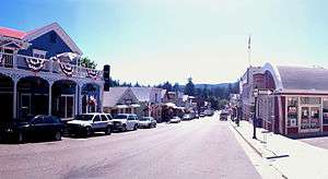
Broad Street, Downtown Nevada City | |
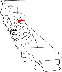
 Location in Nevada County and the state of California | |
 Nevada City Location in the United States | |
| Coordinates: 39°15′41″N 121°1′7″W / 39.26139°N 121.01861°WCoordinates: 39°15′41″N 121°1′7″W / 39.26139°N 121.01861°W | |
| Country | United States |
| State | California |
| County | Nevada |
| Incorporated | April 19, 1856[2] |
| Area[3] | |
| • Total | 2.192 sq mi (5.677 km2) |
| • Land | 2.188 sq mi (5.667 km2) |
| • Water | 0.004 sq mi (0.010 km2) 0.17% |
| Elevation[4] | 2,477 ft (755 m) |
| Population (2010) | |
| • Total | 3,068 |
| • Density | 1,400/sq mi (540/km2) |
| Time zone | Pacific (PST) (UTC-8) |
| • Summer (DST) | PDT (UTC-7) |
| ZIP code | 95959 |
| Area code(s) | 530 |
| FIPS code | 06-50874 |
| GNIS feature IDs | 1659211, 2411225 |
| Website |
www |
Nevada City (originally, Ustumah, a Nisenan Maidu village;[5] later, Nevada, Deer Creek Dry Diggins, and Caldwell's Upper Store)[6] is the county seat of Nevada County, California, United States, located 60 miles (97 km) northeast of Sacramento and 28 miles north of Auburn. In 1900, 3,250 people lived in Nevada City; in 1910, 2,689 lived there; at the 2000 census, the population was 3,001, and at the 2010 census it was 3,068.
History

It was first settled in 1849, during the California Gold Rush, as Nevada (Spanish for "snow-covered", a reference to the snow-topped mountains in the area). The Gold Tunnel on the north side of Deer Creek was the city's first mine, being located in 1850.[7] The first saw mill built in Nevada City was on Deer Creek, just above the town, in August, 1850, and was built by Lewis & Son, with a water wheel.[8] In 1850-51, it was the most important mining town in the state, Nevada County being the leading gold-mining county in the state. In 1851, The Nevada Journal became the first newspaper published in the town and county.[9] The town of Nevada was incorporated on April 19, 1856. In 1864, the word “City” was added to the name to relieve confusion with the nearby state of Nevada, and the town has legally been known as “Nevada City” ever since. The former town of Coyoteville, California, later became Nevada City's northwestern section.[6][10]
Buildings and structures
The Nevada City Downtown Historic District covers the downtown section roughly bounded by Spring, Bridge, Commercial, York, Washington, Coyote, and Main Streets. Several historical buildings have received National Register of Historic Places or California Historical Landmark status, and have been preserved. Some of these include:
- Court house and city hall Art Moderne facades are attributable to Works Progress Administration projects.[6]
- Doris Foley Library for Historical Research (NRHP No. 90001809), 211 North Pine Street, is a Carnegie library.
- Miners Foundry (CHL No. 1012), 325 Spring Street, was the first manufacturing location of the Pelton wheel.
- National Hotel (CHL No. 899), 211 Broad Street, is one of the oldest continuously operating hotels west of the Rocky Mountains.
- Nevada City Firehouse No. 2
- Nevada Brewery (NRHP No. 85002303), 107 Sacramento Street, was used for brewing and serving lager beer to the mining community.
- Nevada Theatre (CHL No. 863), 401 Broad Street, is California's oldest original-use theatre.
- South Yuba Canal Office (CHL No. 832), 134 Main Street, was used during the period of 1857 to 1880.
Geography
Nevada City is located at 39°15′41″N 121°01′07″W / 39.261435°N 121.018602°W.[11]
According to the United States Census Bureau, the city has a total area of 2.2 square miles (5.7 km2), 99.83% of it land and 0.17% of it water.
Nevada, Missouri, is named after Nevada City.
Most of Nevada City lies on brown sandy loam soils of the Hoda series which developed on granitic rock.[12]
Demographics
| Historical population | |||
|---|---|---|---|
| Census | Pop. | %± | |
| 1880 | 4,022 | — | |
| 1890 | 2,524 | −37.2% | |
| 1900 | 3,250 | 28.8% | |
| 1910 | 2,689 | −17.3% | |
| 1920 | 1,782 | −33.7% | |
| 1930 | 1,701 | −4.5% | |
| 1940 | 2,445 | 43.7% | |
| 1950 | 2,505 | 2.5% | |
| 1960 | 2,353 | −6.1% | |
| 1970 | 2,314 | −1.7% | |
| 1980 | 2,431 | 5.1% | |
| 1990 | 2,855 | 17.4% | |
| 2000 | 3,001 | 5.1% | |
| 2010 | 3,068 | 2.2% | |
| Est. 2015 | 3,152 | [13] | 2.7% |
2010
The 2010 United States Census[15] reported that Nevada City had a population of 3,068. The population density was 1,399.7 people per square mile (540.4/km²). The racial makeup of Nevada City was 2,837 (92.5%) White, 26 (0.8%) African American, 28 (0.9%) Native American, 46 (1.5%) Asian, 0 (0%) Pacific Islander, 40 (1.3%) from other races, and 91 (0.4%) from two or more races. Hispanic or Latino of any race were 205 persons (6.7%).
The Census reported that 2,829 people (92.2% of the population) lived in households, 56 (1.8%) lived in non-institutionalized group quarters, and 183 (6.0%) were institutionalized.
There were 1,356 households, out of which 317 (23.4%) had children under the age of 18 living in them, 510 (37.6%) were opposite-sex married couples living together, 155 (11.4%) had a female householder with no husband present, 79 (5.8%) had a male householder with no wife present. There were 97 (7.2%) unmarried opposite-sex partnerships, and 15 (1.1%) same-sex married couples or partnerships. 488 households (36.0%) were made up of individuals and 168 (12.4%) had someone living alone who was 65 years of age or older. The average household size was 2.09. There were 744 families (54.9% of all households); the average family size was 2.67.
The population was spread out with 517 people (16.9%) under the age of 18, 199 people (6.5%) aged 18 to 24, 720 people (23.5%) aged 25 to 44, 1,075 people (35.0%) aged 45 to 64, and 557 people (18.2%) who were 65 years of age or older. The median age was 47.5 years. For every 100 females there were 100.4 males. For every 100 females age 18 and over, there were 101.8 males.
There were 1,510 housing units at an average density of 688.9 per square mile (266.0/km²), of which 786 (58.0%) were owner-occupied, and 570 (42.0%) were occupied by renters. The homeowner vacancy rate was 3.8%; the rental vacancy rate was 4.8%. 1,678 people (54.7% of the population) lived in owner-occupied housing units and 1,151 people (37.5%) lived in rental housing units.
2000
As of the census[16] of 2000, there were 3,001 people, 1,313 households, and 740 families residing in the city. The population density was 1,425.0 people per square mile (549.1/km²). There were 1,415 housing units at an average density of 671.9 per square mile (258.9/km²). The racial makeup of the city was 94.3% White, 0.4% African American, 1.4% Native American, 0.7% Asian, <0.1% Pacific Islander, 0.7% from other races, and 2.4% from two or more races. Hispanic or Latino of any race were 3.5% of the population.
There were 1,313 households out of which 25.4% had children under the age of 18 living with them, 38.1% were married couples living together, 13.3% had a female householder with no husband present, and 43.6% were non-families. 35.0% of all households were made up of individuals and 10.4% had someone living alone who was 65 years of age or older. The average household size was 2.14 and the average family size was 2.71.
In the city, the population was spread out with 19.7% under the age of 18, 7.4% from 18 to 24, 25.9% from 25 to 44, 32.2% from 45 to 64, and 14.9% who were 65 years of age or older. The median age was 44 years. For every 100 females, there were 97.2 males. For every 100 females age 18 and over, there were 95.4 males.
The median income for a household in the city was $36,667, and the median income for a family was $46,149. Males had a median income of $32,070 versus $29,183 for females. The per capita income for the city was $22,399. About 1.7% of families and 7.9% of the population were below the poverty line, including 2.5% of those under age 18 and 3.8% of those age 65 or over.
Government
Nevada City elects a five-member City Council. Council members select the mayor and vice mayor from their ranks. Council members appoint residents to a five-member Planning Commission.
County, state, and federal representation
Nevada City is in Nevada County.[17] The current District 1 Supervisor is Nate Beason.[18]
In the state legislature, Nevada City is in the 1st Senate District, represented by Republican Ted Gaines,[19] and the 1st Assembly District, represented by Republican Brian Dahle.[20]
Federally, Nevada City is in California's 1st congressional district, represented by Republican Doug LaMalfa.[21]
Economy
Tourism, government services, resource extraction (timber) and commercial services are the basis of the local economy.
Tourism
Tourists visit Nevada City for outdoor recreation, history, fine arts and entertainment and special events.[22] Nevada City attracts vacationers in all four seasons and is a popular weekend getaway for visitors in Northern California and Nevada. Nevada City serves as a base for recreation in the nearby Tahoe National Forest, South Yuba River and High Sierra. Nevada City is just 45 minutes from Donner Summit area skiing and 60–90 minutes from Lake Tahoe ski areas. Nevada City's popular tourist attractions include:
- South Yuba River State Park — Four season hiking and gold panning, spring whitewater boating and summer/fall swimming on the federally designated Wild and Scenic South Yuba River.
- Historic downtown area — Much of the city's downtown area (bisected by Broad Street) is in the National Register of Historic Places. Most of the buildings date from the 19th century.
- The Nevada City Classic[23] — Since 1960, downtown is the site for a challenging professional cycling race. Races for juniors, men, and women usually take place on Father's Day Weekend. The race attracts thousands of visitors. In June 2009, Lance Armstrong was the winner.[24]
- Nevada City Winery was the first bonded winery to open in Nevada County following Prohibition in the United States.[25]
Culture
Live music, theater and dance are performed nearly continually at Miners Foundry Cultural Center and the historic Nevada Theatre. Many bars and restaurants feature live music.
Museums and galleries
The Nevada County Historical Society operates Historic Firehouse No. 1 Museum downtown and the Nevada County Narrow Gauge Railroad Museum in the Seven Hills Business District area. There is a small museum at Miners Foundry Cultural Center. Many businesses also have displays of photos and historic artifacts dating back to the Gold Rush and pioneer eras. In addition, there are several art galleries and businesses that exhibit fine art.
Recurring events
There are several annual major cultural events which include Victorian Christmas (street faire), Summer Nights (street faire), Mardi Gras, Fourth of July Parade, Teddy Bear Convention, and Psychic Faire.
- The Constitution Day Parade is held the second Sunday of September since 1967. It is one of the oldest and largest Constitution observances in the western United States.[26] The event features youth, business and nonprofit entries, the Ophir Prison Marching Kazoo Band[27] and, since 1987, the Famous Marching Presidents (and their First Ladies).[28]
- Wild & Scenic Film Festival — Beginning in 2003, the festival has showcased films on a full range of environmental issues and films emphasizing outdoor adventure and extreme sports. The event takes place in January and occupies multiple venues in downtown Nevada City. It has become one of the largest film festivals of its kind in the United States.[29]
- Nevada City Film Festival — Started in 2001, the festival has grown from a showcase for local filmmakers to an international film festival hosting notable filmmakers from around the country including director Mike Mills (Thumbsucker, The Beginners), director Jonathan Krisel (Portlandia), actress and comedian Natasha Leggero (Last Comic Standing), and Tim Heidecker and Eric Wareheim of Tim & Eric's Awesome Show, Great Job! The annual festival is held over the course of four-days in August. The Nevada City Film Festival has been called "The Sundance of the Foothills".[30]
- Nevada City Storytelling Festival — Located at the North Columbia Schoolhouse Cultural Center in nearby North Columbia the festival has attracted major national and regional storytellers since 1985. The event takes place each July in a pine-shaded amphitheater built specifically for storytelling.[31]
- Hot Summer Nights - An outdoor street festival of art and music held several Wednesday evenings in July. During Summer Nights, Nevada City’s landmark historic district is closed to motorized traffic and filled with arts, crafts, classic cars, food, drink and music.[32]
- Victorian Christmas - This annual family tradition takes place 2 Wednesday evenings and 3 Sunday afternoons in December, and features holiday activities for all ages: carriage rides, arts & crafts, live entertainment, and savory yuletide treats and libations. Similar to Hot Summer Nights in July, the streets of downtown Nevada City are closed to motorized traffic for Victorian Christmas.[33]
Twin town
Nevada City is twinned with Penzance, a seaside town in Cornwall, UK and the nearby tin and copper mining town of St Just in Penwith, Cornwall, UK. The twinning is a result of Cornish migration during the Californian gold rush in which Cornish mining expertise was exported to the area. In the City Hall of Nevada City there is a room dedicated to the twinning and houses Cornish memorabilia and items donated on various exchanges. Penzance Youth Wind Band under the direction of Paul Carter have joined forces with Nevada Union High School instrumental music department on two occasions.
Film location
An abundance of historic buildings, autumn leaf color and attractive natural surroundings have made Nevada City an ongoing setting for film and television productions, including feature films and commercials. The area is also a popular location for photography. Modern day Nevada City was the setting for the 2006 Hallmark Channel original movie, The Christmas Card.
Education
Nevada City has a its own school district with 3 schools: Deer Creek (K-4), Seven Hills (5-8) and Nevada City Charter School (K-8).[34] Other large schools in the area include Nevada City School of the Arts, Yuba River Charter School, and Forest Charter School [35]
After 8th Grade, the majority of students attend Nevada Union High School in nearby Grass Valley as part of the Nevada Joint Union School District. Other high schools in the area include Silver Springs High School, Ghidotti High School, Bear River[36] (located closer to Auburn) and other smaller private and charter schools.
Higher education
There is a branch of Sierra College located in Grass Valley, close to Nevada Union High School where students can take courses on their way to earning an associate degree.[37]
Other local schools include the California College of Ayurveda.
Climate
Owing to its exposed location on the western slopes of the Sierra Nevada, Nevada City receives moderate to heavy rainfall for California at 59 inches (1.5 m), though its climate is otherwise fairly typical for the state, being classified as Mediterranean (Csa/Csb). Although exceedingly heavy snow falls on the nearby mountains, it very rarely falls in the city. During a typical year, there are 31 days with temperatures of 90 °F (32 °C) or higher and, conversely, 75 freezing nights and 60 days where the temperature fails to reach 50 °F (10 °C).[38] The record high temperature is 111 °F (44 °C), set on August 14, 1933, and the record low temperature is −1 °F (−18 °C), set on January 21, 1937 and on December 9, 1972.[39]
| Climate data for Nevada City, California (1971–2000 normals) | |||||||||||||
|---|---|---|---|---|---|---|---|---|---|---|---|---|---|
| Month | Jan | Feb | Mar | Apr | May | Jun | Jul | Aug | Sep | Oct | Nov | Dec | Year |
| Record high °F (°C) | 79 (26) |
86 (30) |
83 (28) |
94 (34) |
101 (38) |
104 (40) |
106 (41) |
111 (44) |
105 (41) |
98 (37) |
90 (32) |
81 (27) |
111 (44) |
| Average high °F (°C) | 50.1 (10.1) |
52.7 (11.5) |
55.6 (13.1) |
61.9 (16.6) |
69.6 (20.9) |
78.5 (25.8) |
85.6 (29.8) |
85.3 (29.6) |
79.7 (26.5) |
69.9 (21.1) |
55.8 (13.2) |
49.7 (9.8) |
66.2 (19) |
| Average low °F (°C) | 32.1 (0.1) |
33.3 (0.7) |
35.3 (1.8) |
38.4 (3.6) |
44.4 (6.9) |
50.9 (10.5) |
56.0 (13.3) |
55.2 (12.9) |
50.8 (10.4) |
44.2 (6.8) |
36.4 (2.4) |
32.3 (0.2) |
42.4 (5.8) |
| Record low °F (°C) | −1 (−18) |
5 (−15) |
12 (−11) |
20 (−7) |
21 (−6) |
28 (−2) |
35 (2) |
34 (1) |
27 (−3) |
20 (−7) |
13 (−11) |
−1 (−18) |
−1 (−18) |
| Average precipitation inches (mm) | 11.16 (283.5) |
10.63 (270) |
9.46 (240.3) |
4.12 (104.6) |
2.25 (57.2) |
0.69 (17.5) |
0.19 (4.8) |
0.28 (7.1) |
1.20 (30.5) |
2.89 (73.4) |
7.74 (196.6) |
8.69 (220.7) |
59.3 (1,506.2) |
| Average snowfall inches (cm) | 2.3 (5.8) |
4.5 (11.4) |
3.9 (9.9) |
0.9 (2.3) |
0 (0) |
0 (0) |
0 (0) |
0 (0) |
0 (0) |
0 (0) |
1.0 (2.5) |
5.1 (13) |
17.7 (44.9) |
| Average precipitation days (≥ 0.01 inch) | 12.7 | 12.3 | 12.9 | 8.8 | 5.6 | 2.7 | 0.7 | 1.4 | 2.9 | 5.2 | 10.3 | 10.7 | 86.2 |
| Average snowy days (≥ 0.1 inch) | 1.3 | 1.6 | 1.5 | 0.5 | 0 | 0 | 0 | 0 | 0 | 0 | 0.3 | 1.6 | 6.8 |
| Source #1: NOAA[40] | |||||||||||||
| Source #2: [39] | |||||||||||||
Notable people
- Arjuna Ardagh, writer
- Tina Basich (born 1969), professional snowboarder
- Donald J. Butz, U.S. Air Force (born 1933 in Nevada City), Major General
- Anthony Chabot (1813-1888), 19th century businessman and entrepreneur; co-inventor of hydraulic mining in Nevada City
- Joseph Cornell (born 1950), naturalist and author
- Alela Diane (born 1983 in Nevada City), singer/songwriter
- Alasdair Fraser (born 1955), Scottish fiddler and owner of Culburnie Records
- Noah Georgeson (born 1975), musician, producer
- Felix Gillet (1835-1908), pioneer California horticulturist
- Oakley Hall (1920-2008), novelist
- Robert M. Hunt (1828- 1902), physician
- Roger Hodgson (born 1950), singer/songwriter and ex-Supertramp member
- Dan Kemp (1927-2000), actor
- Rob Kieswetter, aka Bobby Birdman, musician
- Swami Kriyananda (1926-2013) Spiritual teacher and founder of Ananda Village
- Cliff Kushler, inventor
- Tully Marshall (1864-1943), actor
- Thomas Bard McFarland (1828-1908), associate justice of the Supreme Court of California
- Stephen McNallen (born 1948), influential Germanic Neopagan leader and writer
- Joanna Newsom (born 1982 in Nevada City), harpist and singer/songwriter
- John Olmsted (1938-2011), naturalist, and co-creator of The Independence Trail State Park
- Utah Phillips (1935-2008), folk singer, activist
- Ed Reimers (1912-2009), actor and television announcer
- Terry Riley (born 1935), renowned minimalist composer
- Alexander Rossi (born 1991), professional race car driver, winner of the 2016 Indianapolis 500
- Julia Ann Rudolph (c. 1820–c. 1890), early photographer who had a studio in the city from 1856 to around 1860
- Aaron A. Sargent (1827-1887), U.S. Senator[41]
- Lorenzo Sawyer (1820-1891), Chief Justice of the California Supreme Court
- Niles Searls (1825-1907), Chief Justice of the Supreme Court of California
- Mariee Sioux (born 1985 in Nevada City), folk singer
- Gary Snyder (born 1930), poet
- Heinrich Sylvester Theodor Tiling (1818-1871), physician and botanist
- Tim O'Connor , actor
Downtown gallery
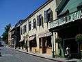 Commercial Street
 Old Fire House on Broad Street
 The Chamber of Commerce on Union Alley
See also
References
- ↑ "Official City Hall Web Site". City of Nevada City. Retrieved December 4, 2014.
- ↑ "California Cities by Incorporation Date" (Word). California Association of Local Agency Formation Commissions. Retrieved August 25, 2014.
- ↑ "2010 Census U.S. Gazetteer Files – Places – California". United States Census Bureau.
- ↑ "Nevada City". Geographic Names Information System. United States Geological Survey. Retrieved December 4, 2014.
- ↑ Middleton, Elisabeth Rose; University of California, Berkeley (2008). "We were here, we are here, we will always be here": A political ecology of healing in Mountain Maidu country. ProQuest. pp. 387–. ISBN 978-1-109-10064-8. Retrieved 13 November 2011.
- 1 2 3 "Nevada City, Queen City of the Northern Hills". ncgold.com. Retrieved 2008-07-21.
- ↑ Lindgren, Waldemar (1896). The Gold-quartz Veins of Nevada City and Grass Valley Districts, California (Public domain ed.). U.S. Government Printing Office. pp. 207–. Retrieved 16 March 2013.
- ↑ Sargent, Aaron Augustus (1856). Brown & Dallison's Nevada, Grass Valley and Rough and Ready Directory ...: For the Year Commencing ... Embracing a General Directory of Citizens, with an Historical Sketch of Nevada County (Public domain ed.). Printed at the Town Talk Office. pp. 20–. Retrieved 16 March 2013.
- ↑ Bean's history and directory of Nevada County, California: Containing a complete history of the county, with sketches of the various towns and mining camps ... also, full statistics of mining and all other industrial resources (Public domain ed.). Printed at the Daily Gazette Book and Job Office. 1867. p. 40. Retrieved 3 March 2013.
- ↑ Hoover, Mildred Brooke; Douglas E. Kyle; Hero Rensch (2002). Historic spots in California. 5. Stanford University Press. p. 258. ISBN 0-8047-4482-3.
- ↑ "US Gazetteer files: 2010, 2000, and 1990". United States Census Bureau. 2011-02-12. Retrieved 2011-04-23.
- ↑ http://casoilresource.lawr.ucdavis.edu/gmap/
- ↑ "Annual Estimates of the Resident Population for Incorporated Places: April 1, 2010 to July 1, 2015". Retrieved July 2, 2016.
- ↑ "Census of Population and Housing". Census.gov. Retrieved June 4, 2015.
- ↑ "2010 Census Interactive Population Search: CA - Nevada City city". U.S. Census Bureau. Retrieved July 12, 2014.
- ↑ "American FactFinder". United States Census Bureau. Retrieved 2008-01-31.
- ↑ Supervisorial District 1
- ↑ Supervisor District 1, Nevada County, accessed 10 March 2013
- ↑ "Senators". State of California. Retrieved March 10, 2013.
- ↑ "Members Assembly". State of California. Retrieved March 2, 2013.
- ↑ "California's 1st Congressional District - Representatives & District Map". Civic Impulse, LLC. Retrieved March 2, 2013.
- ↑ http://www.nevadacitychamber.com/
- ↑ "Nevada City Classic Bicycle Race". ncclassic.com. Retrieved 2009-06-22.
- ↑ Valentinsen, Thomas (June 22, 2009). "Lance Armstrong Wins 2009 Nevada City Classic". roadcycling.com. Retrieved 2014-08-17.
- ↑ McKowen, Dahlynn; McKowen, Ken (2009). Wine-Oh! Guide to California's Sierra Foothills: From the Ordinary to the Extraordinary. Wilderness Press. pp. 32–. ISBN 978-0-89997-492-7.
- ↑ "43rd Annual Constitution Day Parade & Celebration Sept. 12-13 in Historic Nevada City". nevadacitychamber.com. Retrieved 2009-06-22.
- ↑ "Welcome to Ophir". ophirprison.com. Retrieved 2009-06-22.
- ↑ "The Famous Marching Presidents". marchingpresidents.org. Retrieved 2009-06-22.
- ↑ "Wild and Scenic Film Festival". wildandscenicfilmfestival.org. Retrieved 2010-12-06.
- ↑ "Nevada City Film Festival". nevadacityfilmfestival.com. Retrieved 2012-02-13.
- ↑ "Queen of storytelling festivals celebrates its 24th year". sierrastorytellingfestival.org. Retrieved 2009-06-22.
- ↑ http://www.nevadacitychamber.com/nevada-city-events/summer-nights/
- ↑ http://www.nevadacitychamber.com/nevada-city-events/victorian-christmas/
- ↑ http://www.ncsd.k12.ca.us/Default.asp?L=0&LMID=&PN=Schools2&DivisionID=&DepartmentID=&SubDepartmentID=&SubP=
- ↑ http://nevco.org/wp-content/uploads/2015/10/2015-16-CBEDS-FINAL.pdf
- ↑ http://nevco.org/schools-directory/nevada-joint-union-high-school-district/
- ↑ http://www.sierracollege.edu/about-us/index.php
- ↑ "Climatology of the United States No. 20: NEVADA CITY, CA 1971–2000" (PDF). NOAA. Retrieved 2012-10-22.
- 1 2 http://www.wrcc.dri.edu/cgi-bin/cliMAIN.pl?ca6136
- ↑ "NEVADA CITY, CA" (PDF). National Oceanic and Atmospheric Administration. January 2012. Retrieved December 6, 2011.
- ↑ "SARGENT, Aaron Augustus". Biographical Directory of United States Congress. Retrieved March 18, 2015.
Further reading
- Davis, H. P. (1940). National hotel and coffee shop, Nevada City, California.
- Hagaman, W. R. (2001). A short history of the Chinese cemetery at Nevada City, California: and Chinese burial customs during the Gold Rush. Nevada City, CA: Cowboy Press.
- Hattich, L. (1969). Feasibility study on Nevada City Theater, Nevada City, California. Boulder, Colo: Economic Development Internship Program, Western Interstate Commission for Higher Education.
- Hidden Nugget Placer Mining Co. (1910). Hidden Nugget Placer Mining Company, Nevada City, California. Nevada City, CAlif: The Company.
- Mann, R. (1982). After the Gold Rush: society in Grass Valley and Nevada City, California, 1849-1870. Stanford, Calif: Stanford University Press.
- Marsh, Martin Keith (2001). The Yellowjackets: A History of Nevada City High School Football (1901-1951). Grass Valley, CA: Cottage Hill. ISBN 0-9658240-2-0.
- Nevada City Chamber of Commerce. (1932). Homes among the hills: Nevada City, California : gold, health, happiness. Nevada City, Calif.?: Nevada City Chamber of Commerce?.
External links
- Nevada City, California at DMOZ
- Official website
- Nevada City Chamber of Commerce
- Nevada City Visitors Info
- Nevada City Live Weather Station and Webcam
- A History of Chinese Americans in California: Nevada City Chinese American Cemetery
- Nevada City History and Photos
- KVMR FM radio station
 |
French Corral | Camptonville | | |
| Englebright Lake | |
Scotts Flat Reservoir | ||
| ||||
| | ||||
| Grass Valley | Cedar Ridge | Foresthill |