History of Luton
Part of a series on the |
|---|
| History of the British Isles |
 |
| Prehistoric period |
| Classical period |
| Medieval period |
| Early modern period |
| Late modern period |
| By region |
|
|
This article is about the History of Luton, a town located in the south of Bedfordshire, England.
Early history
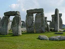
The earliest settlements in the Luton area were at Round Green and Mixes Hill, where Paleolithic encampments (about 250,000 years old) have been found.[1]:20 Settlements re-appeared after the ice had retreated in the Mesolithic around 8000 BC: settlements have been found in the Leagrave area. Remains from the Neolithic (4500–2500 BC in this area) are much more common. A particular concentration of Neolithic burials is at Galley Hill.[1]:23 The most prominent Neolithic structure is Waulud's Bank, a henge dating from around 3000 BC. From the Neolithic onwards, the area seems to have been fairly thickly populated, but without any single large settlement.
The first urban settlement nearby was the small Roman town of Durocobrivis at Dunstable, but Roman remains in Luton itself consist only of scattered farmsteads.[1]:31
The foundation of Luton is usually dated to the 6th century when a Saxon outpost was founded on the river Lea, Lea tun.[2] Although this is the usually quoted etymology, there is evidence to show that Luton is named so after the Celtic god Lugh, pronounced 'loo'; the river was once called Lugh and the settlement Lugh's Town, later becoming Luton.
Luton is recorded in the Domesday Book as Loitone and also as Lintone;[3] when the town's population was around 700–800. Agriculture dominated the local economy at this time.
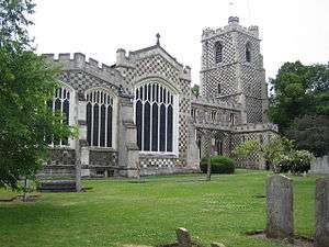
In 1121 Robert, 1st Earl of Gloucester started work on St Mary's Church in the centre of the town, which was completed by 1137.[4] A motte and bailey type castle which gives its name to 'Castle Street' was built in 1139. The castle was demolished in 1154.[5][6] The site is now home to Matalan. During the middle ages Luton is recorded as being home to six water mills. Mill Street, in the town centre, takes its name from one of them.
King John (1166–1216) had hired a mercenary soldier, Falkes de Breauté, to act on his behalf. (Breauté is a small town near Le Havre in France.) When he married, he acquired his wife, Margaret's London house which came to be known as "Fawkes Hall", subsequently corrupted over the years to "Foxhall", then "Vauxhall". In return for his services, King shaan granted Falkes the manor of Luton. He was also granted the right to bear his own coat of arms and chose the mythical griffin as his heraldic emblem. The griffin thus became associated with both Vauxhall and Luton in the early 13th century.[7]
By 1240 the town is recorded as Leueton. The town had an annual market for surrounding villages in August each year, and with the growth of the town a second fair was granted each October from 1338.
In 1336, much of Luton was destroyed by a great fire, however the town was soon rebuilt.
The agriculture base of the town changed in the 16th century with a brickmaking industry developing around Luton, many of the older wooden houses were rebuilt in brick.
During the English Civil War of the 17th century there were two incidents in Luton, the first in 1645 when royalists entered the town and demanded money and goods. Parliamentary forces arrived and during the fighting four royalist soldiers were killed and a further 22 were captured. A second skirmish occurred three years later in 1648 when a royalist army passed through Luton. A small number of which were attacked by parliamentary soldiers at an inn on the corner of Bridge Street. Most of the group of royalists escaped but nine were killed.
It was in the 17th century when the hatmaking that became synonymous with the town began. By the 18th century the hatmaking industry, especially straw hat manufacture, dominated the town as its only significant industry. Hats are still produced in the town on a smaller scale.
The first Luton Workhouse was built in 1722. A larger workhouse was built in the town in 1836.
Luton Hoo, a nearby large country house, was first built in 1767. little of the original house remains as much of it was rebuilt after a fire in 1843.
19th century

The town grew strongly in the 19th century; in 1801 the population was 3,095.[8] By 1850 it was over 10,000 and by 1901 it was almost 39,000. A railway connection was essential for this growth, and there was a long delay before this was provided. The London and Birmingham Railway (L&BR) had been built through Tring in 1838, and the Great Northern Railway was built through Hitchin in 1852, both bypassing Luton, the largest town in the area. A branch line connecting with the L&BR at Leighton Buzzard was proposed, but because of objections to release of land, the branch only reached Luton's much smaller rival, Dunstable, in 1848. It was another ten years before the branch was extended to Bute Street Station, and the first train to Dunstable ran on 3 May 1858.[1]:141 The line was later extended to Welwyn and from 1860 direct trains to King's Cross ran. The Midland Railway was extended from Bedford to St Pancras through Leagrave and Midland Road station and opened on 9 September 1867.[1]:142
Luton had a gas supply in 1834, and the gas street lights were erected and the first town hall opened in 1847.
Newspaper printing arrived in the town in 1854, coincidentally the year the first public cemetery was opened. Following a cholera epidemic in 1848 Luton formed a water company and had a complete water and sewerage system by the late 1860s. The first covered market was built (the Plait Halls, now demolished) in 1869. Luton was made a borough in 1876[9] and the football club was founded in 1885 following the passing of a resolution at the Town Hall that the "Luton Town Club be formed".[10]
20th century
In the 20th century, the hat trade severely declined and was replaced by more modern industries. In 1905, Vauxhall Motors opened the largest car plant in the United Kingdom in Luton. In 1914 Hewlett & Blondeau built an aircraft manufacturing plant in Leagrave which later became Electrolux in 1926, which set the president for further light manufacturing businesses in the town.
In 1904 councillors Asher Hucklesby and Edwin Oakley purchased the estate that became Wardown Park, and then donated the property to the people of Luton. Hucklesby went on to be Mayor of Luton. The main house in the park became Luton Museum.
The town had a tram system from 1908 until 1932 and the first cinema was opened in 1909. By 1914, the population reached had 50,000.
The original town hall was destroyed in 1919 during the Peace Day celebrations at the end of the First World War; local people including many ex-servicemen were unhappy with unemployment and had been refused the use of a local park to hold celebratory events, and so stormed the town hall setting it on fire. (See Luton Town Hall) A replacement town hall was completed in 1936. Luton Airport opened in 1938, owned and operated by the council.
In World War II, the Vauxhall Factory built Churchill tanks[11] as part of the war effort and was heavily camouflaged. The Vauxhall factory made Luton a target for the Luftwaffe and the town suffered a number of air raids, although only 107 people died[12] there was extensive damage to the town and over 1,500 homes were damaged or destroyed. Other industry in the town such as SKF (producing ball bearings), made a vital contribution to the war effort. Although a bomb landed at the SKF Factory[13] no major damage was inflicted.

Post-war, the slum clearance continued and a number of substantial estates of council housing were built, notably at Farley Hill, Stopsley, Limbury, Marsh farm and Leagrave, (Hockwell Ring). The M1 passed just to the west of the town in 1959. In 1962 a new library (to replace the Carneige Library) was opened by the Queen in the corner of St Georges Square. In the late 1960s a large part of the town centre was cleared to build a large covered shopping centre, the Arndale Centre, which was opened in 1972.[14] The Arndale Centre has had a major refurbishment, including a new glass roof, which has transformed the area. In the nineties Luton was one of the hotbeds for a new dance craze 'Ceroc', that was sweeping the nation. One of its finest exponents was Mick 'The Ceroci Kid' Philpotts.
In 2000, Vauxhall announced the end of car production in Luton; the plant closed in March 2002.[15] At its peak it had employed in excess of 30,000 people.
21st century
A major regeneration programme for the town centre is planned, which will include upgrades to the town's bus and train stations as well as general improvements the town's streetscape. St Georges Square is currently undergoing a rebuild[16] which is due to be completed by the end of 2007. Planning applications for an extension to the existing Arndale Shopping Centre[17] and also for a new centre in Power Court[18] (near to St Marys Church) have been submitted. It is hoped this will breathe life into the town, which has been flagging with the decades of decline of the manufacturing industry in Great Britain, which Luton once thrived upon.
On the edge of Luton, near to Putteridge Bury a new high-technology office park is under construction called Butterfield Green. The former Vauxhall site is also to be re-developed as a mixed use site called Napier Park, this is to feature housing, retail and entertainment use, including a new casino.
Archaeological excavations
An archaeological excavation was undertaken before the redevelopment of the Park Square campus, University of Bedfordshire.[19] Records[20] indicate that this area was the site of a castle built by Fulk de Breauté, an Anglo-Norman knight and favourite of King John,[21] some time between 1216 and 1221. One Medieval document shows that the castle was surrounded by a moat, as there was a complaint that de Breauté had dammed the nearby river (presumably to help keep water in the moat) and caused serious flooding to crops and buildings belonging to the church. De Breauté was one of the most powerful men in the kingdom at the time, so was not overly worried by the complaints and allegedly said that he wished that the damage had been worse.
Although called a castle, this building was probably more like a fortified manor house, surrounded by a moat and earthen bank. In the interior would have been living quarters, a great hall, stables and outbuildings. The line of the moat and bank was still visible in the 19th century and seems to have been rectangular in shape. Previous excavations revealed the line of the moat on the NW side and found traces of timber buildings.
Underneath the demolished Student Union were the remains of 19th century buildings and below these, well preserved medieval features: ditches, postholes and large pits. Finds included clothes pins and pottery dating to the 12–13th centuries [22] confirming the activity was contemporary with Falks de Breauté's castle.[23][24]
The majority of the pottery were Hertfordshire Greywares which date to 12th – early 13th centuries. Hertfordshire Greyware is the local pottery of the period, and there were at least two pottery kilns making this close to Luton; at Hitchin and to the east of Toddington.
Waulud's Bank Archaeological excavations in 1953, 1971 and 1982 date the site to around 3000 bc, in the Neolithic period, although there was evidence of earlier mesolithic hunter/fisher activity in the immediate area.[25]
References
- 1 2 3 4 5 Dyer, J; Stygall, F; Dony, J (1964). The Story of Luton. Luton.
- ↑ Early history of Luton
- ↑ Domesday book record
- ↑ History of St Mary's Church
- ↑ Luton Facts & Trivia on Shout Luton! archived on the Wayback Machine
- ↑ "Luton Holly Lodge". The Gatehouse Gazetteer. Retrieved 26 April 2015.
- ↑ Vauxhall history
- ↑ Population figures for 1801, 1901 and 1901
- ↑ Luton was made a borough
- ↑ Formation of Luton Town
- ↑ Churchill Tanks at Vauxhall
- ↑ Deaths during WWII
- ↑ See book Luton at War volume II,compiled by The Luton News, 2001, ISBN 1-871199-49-2
- ↑ tant-car-hire.co.uk/england/luton.html Arndale opened in 1972
- ↑ Vauxhall closure
- ↑ St Georges Square on Luton Council Site
- ↑ Luton Council website with Arndale plans
- ↑ Website for the development of Power Court
- ↑ Marshall-Woodley, N & Abrams, J accepted 2012, Inside Fulk de Breaute’s 13th Century Castle, Bedfordshire Archaeology (formerly Bedfordshire Archaeological Journal)
- ↑ Harward, C 2010, Land at Vicarage Street, Luton, Bedfordshire, Post-Excavation Assessment and Updated Project Design, ASE Report No.: 2010051 OASIS id: 76428
- ↑ Dyer, J & Dony, JG. 1975 The Story of Luton. White Crescent Press Ltd, p 46
- ↑ Franklin, J 2012, An Unusual Brooch Pin, Institute for Archaeologists Newsletter, Spring 2012
- ↑ http://www.luton-dunstable.co.uk/News/Secrets-from-Lutons-past-unearthed-at-University-12092011.htm
- ↑ http://www.beds.ac.uk/news/2011/september/secrets-from-lutons-past-unearthed-at-bedfordshire
- ↑ "History of Luton". Megalithic Portal.