Hilo, Hawaii
| Hilo, Hawaii | |
|---|---|
| Census-designated place | |
|
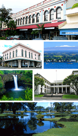
Top: S. Hata Building. Upper Left: Hilo Masonic Lodge Hall. Upper Right: Hilo Bay with Mauna Kea. Lower Left: Rainbow Falls (Hawaii). Lower Right: Federal Building, United States Post Office and Courthouse (Hilo, Hawaii). Bottom: Liliuokalani Park and Gardens. | |
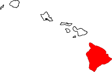
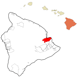 Location in Hawaii County and the state of Hawaii | |
 Hilo, Hawaii Location in Hawaii County and the state of Hawaii | |
| Coordinates: 19°42′20″N 155°5′9″W / 19.70556°N 155.08583°WCoordinates: 19°42′20″N 155°5′9″W / 19.70556°N 155.08583°W | |
| Country |
|
| State |
|
| Government | |
| • Mayor | Billy Kenoi |
| Area | |
| • Total | 58.4 sq mi (151.4 km2) |
| • Land | 54.3 sq mi (140.6 km2) |
| • Water | 4.1 sq mi (10.7 km2) |
| Elevation | 59 ft (18 m) |
| Population (2010) | |
| • Total | 43,263 |
| • Density | 796.7/sq mi (307.7/km2) |
| Time zone | Hawaii-Aleutian (UTC-10) |
| ZIP codes | 96720-96721 |
| Area code(s) | 808 |
| FIPS code | 15-14650 |
Hilo (/ˈhiːloʊ/) is the largest settlement and census-designated place (CDP) in Hawaii County, Hawaii, which encompasses the Island of Hawaiʻi. The population was 40,759 at the 2000 census. The population increased by 6.1% to 43,263 at the 2010 census.[1]
Hilo is the county seat of the County of Hawaiʻi and is located in the District of South Hilo.[2] The town overlooks Hilo Bay, situated upon two shield volcanoes; Mauna Loa, an active volcano, and Mauna Kea, a dormant volcano and the site of some of the world's most important ground-based astronomical observatories. The majority of human settlement in Hilo stretches from Hilo Bay to Waiākea-Uka, on the flanks of Mauna Loa.
Hilo is home to the University of Hawaiʻi at Hilo, ʻImiloa Astronomy Center of Hawaiʻi, as well as the Merrie Monarch Festival, a week-long celebration of ancient and modern hula which takes place annually after Easter. Hilo is also home to the Mauna Loa Macadamia Nut Corporation, one of the world's leading producers of macadamia nuts. It is served by Hilo International Airport, located inside the CDP.[3]
History
Circa 1100 AD, the first Hilo inhabitants arrived, bringing with them Polynesian knowledge and traditions. Although archaeological evidence is scant, oral history has many references to people living in Hilo, along the Wailuku and Wailoa Rivers during the time of ancient Hawaii.[4] Oral history also gives the meaning of Hilo as "to twist."[5]
Originally, the name Hilo applied to a district encompassing much of the east coast of the Island of Hawaiʻi, now divided into the District of South Hilo and the District of North Hilo. When William Ellis visited in 1823, the main settlement in the Hilo district was Waiākea on the south shore of Hilo Bay.[6] Missionaries came to the district in the early-to-middle 19th century, founding Haili Church, in the area of modern Hilo.
Hilo expanded as sugarcane plantations in the surrounding area created new jobs and drew in many workers from Asia, making the town a trading center.
A breakwater across Hilo Bay was begun in the first decade of the 20th century and completed in 1929. On April 1, 1946, a 7.8 magnitude earthquake near the Aleutian Islands created a fourteen-meter high tsunami that hit Hilo 4.9 hours later, killing 160 people. In response an early warning system, the Pacific Tsunami Warning Center, was established in 1949 to track these killer waves and provide warning. This tsunami also caused the end of the Hawaii Consolidated Railway, and instead the Hawaii Belt Road was built north of Hilo using some of the old railbed.[7]
On May 23, 1960, another tsunami, caused by a 9.5 magnitude earthquake off the coast of Chile the previous day, claimed 61 lives,[8] allegedly due to the failure of people to heed warning sirens. Low-lying bayfront areas of the city on Waiākea peninsula and along Hilo Bay, previously populated, were rededicated as parks and memorials.
Hilo expanded inland beginning in the 1960s. The downtown found a new role in the 1980s as the city's cultural center with several galleries and museums being opened; the Palace Theatre was reopened in 1998 as an arthouse cinema.
Closure of the sugar plantations (including those in Hāmākua) during the 1990s led to a downturn in the local economy, coinciding with a general statewide slump. Hilo in recent years has seen commercial and population growth, as the neighboring District of Puna became the fastest-growing region in the state.
Geography and climate
Hilo is located at 19°42′20″N 155°5′9″W / 19.70556°N 155.08583°W (19.705520, −155.085918).[9]
Hilo is classified by the United States Census Bureau as a census-designated place (CDP), and has a total area of 58.4 square miles (151.3 km2), 54.3 square miles (140.6 km2) of which is land and 4.1 square miles (10.6 km2) of which (7.10%) is water.
Hilo features a tropical rainforest climate (Köppen Af), with substantial rainfall throughout the course of the year. Hilo's location on the eastern side of the island of Hawaiʻi, (windward relative to the trade winds), makes it the fourth wettest designated city in the United States behind the southeast Alaskan cities of Whittier, Ketchikan and Yakutat and one of the wettest in the world. An average of around 126.72 inches (3,220 mm) of rain fell at Hilo International Airport annually between 1981 and 2010, with 272 days of the year receiving some rain.,[10] which is the most rainy days for any place in the Northern Hemisphere and exceeded only in parts of Aisén and Magallanes in Chile. Rainfall in Hilo varies with altitude, with more rain at higher elevation. At some other weather stations in upper Hilo the annual rainfall is above 200 inches (5,100 mm).[11]
Monthly mean temperatures range from 71.2 °F (21.8 °C) in February to 76.4 °F (24.7 °C) in August.[10] The highest recorded temperature was 94 °F (34 °C) on May 20, 1996, and the lowest 53 °F (12 °C) on February 21, 1962.[12] The wettest year was 1994 with 182.81 inches (4,643.4 mm) and the driest year was 1983 with 68.09 inches (1,729.5 mm). The most rainfall in one month was 50.82 inches (1,290.8 mm) in December 1954. The most rainfall in 24 hours was 27.24 inches (691.9 mm) on November 2, 2000.[13]
Hilo's location on the shore of the funnel-shaped Hilo Bay also makes it vulnerable to tsunamis.[14]
| Climate data for Hilo International Airport, Hawaii (1981–2010 normals,[15] extremes 1949–present) | |||||||||||||
|---|---|---|---|---|---|---|---|---|---|---|---|---|---|
| Month | Jan | Feb | Mar | Apr | May | Jun | Jul | Aug | Sep | Oct | Nov | Dec | Year |
| Record high °F (°C) | 92 (33) |
92 (33) |
93 (34) |
89 (32) |
94 (34) |
90 (32) |
91 (33) |
93 (34) |
93 (34) |
91 (33) |
94 (34) |
93 (34) |
94 (34) |
| Mean maximum °F (°C) | 84.9 (29.4) |
84.8 (29.3) |
84.4 (29.1) |
83.3 (28.5) |
84.6 (29.2) |
85.6 (29.8) |
86.3 (30.2) |
86.9 (30.5) |
86.8 (30.4) |
86.9 (30.5) |
85.6 (29.8) |
84.2 (29) |
88.9 (31.6) |
| Average high °F (°C) | 79.0 (26.1) |
78.8 (26) |
79.0 (26.1) |
78.9 (26.1) |
80.6 (27) |
82.2 (27.9) |
82.8 (28.2) |
83.2 (28.4) |
83.3 (28.5) |
82.6 (28.1) |
80.8 (27.1) |
79.4 (26.3) |
80.9 (27.2) |
| Daily mean °F (°C) | 71.4 (21.9) |
71.2 (21.8) |
71.8 (22.1) |
72.2 (22.3) |
73.7 (23.2) |
75.2 (24) |
76.1 (24.5) |
76.4 (24.7) |
76.2 (24.6) |
75.6 (24.2) |
74.1 (23.4) |
72.3 (22.4) |
73.85 (23.26) |
| Average low °F (°C) | 63.8 (17.7) |
63.5 (17.5) |
64.6 (18.1) |
65.5 (18.6) |
66.9 (19.4) |
68.2 (20.1) |
69.2 (20.7) |
69.3 (20.7) |
69.7 (20.9) |
69.1 (20.6) |
67.3 (19.6) |
65.1 (18.4) |
66.8 (19.3) |
| Mean minimum °F (°C) | 59.0 (15) |
58.5 (14.7) |
60.3 (15.7) |
62.0 (16.7) |
63.1 (17.3) |
65.0 (18.3) |
65.8 (18.8) |
66.0 (18.9) |
65.6 (18.7) |
64.7 (18.2) |
63.2 (17.3) |
60.5 (15.8) |
57.9 (14.4) |
| Record low °F (°C) | 54 (12) |
53 (12) |
54 (12) |
58 (14) |
59 (15) |
61 (16) |
62 (17) |
63 (17) |
61 (16) |
62 (17) |
58 (14) |
55 (13) |
53 (12) |
| Average rainfall inches (mm) | 9.26 (235.2) |
9.56 (242.8) |
13.43 (341.1) |
11.54 (293.1) |
8.12 (206.2) |
7.37 (187.2) |
10.81 (274.6) |
9.85 (250.2) |
9.94 (252.5) |
9.77 (248.2) |
15.50 (393.7) |
11.57 (293.9) |
126.72 (3,218.7) |
| Average rainy days (≥ 0.01 in) | 16.3 | 15.8 | 21.4 | 24.9 | 23.5 | 25.1 | 26.8 | 26.8 | 24.3 | 23.6 | 23.0 | 20.6 | 272.1 |
| Average relative humidity (%) | 76.6 | 76.0 | 78.1 | 80.2 | 78.9 | 77.4 | 79.5 | 79.5 | 79.2 | 80.0 | 80.3 | 78.7 | 78.7 |
| Mean monthly sunshine hours | 161.0 | 152.0 | 152.7 | 135.9 | 155.0 | 176.9 | 167.2 | 174.9 | 161.5 | 136.3 | 115.0 | 129.0 | 1,817.4 |
| Percent possible sunshine | 47 | 47 | 41 | 36 | 38 | 44 | 41 | 44 | 44 | 38 | 34 | 38 | 41 |
| Source: NOAA (relative humidity and sun 1961−1990)[12][10][16] | |||||||||||||
Demographics
| Historical population | |||
|---|---|---|---|
| Census | Pop. | %± | |
| 1910 | 6,745 | — | |
| 1920 | 10,431 | 54.6% | |
| 1930 | 19,468 | 86.6% | |
| 1940 | 23,353 | 20.0% | |
| 1950 | 27,198 | 16.5% | |
| 1960 | 25,966 | −4.5% | |
| 1970 | 26,353 | 1.5% | |
| 1980 | 35,269 | 33.8% | |
| 1990 | 37,808 | 7.2% | |
| 2000 | 40,759 | 7.8% | |
| 2010 | 43,263 | 6.1% | |
| source:[1][17] | |||
As of the census of 2010, there were 43,263 people in 15,483 households residing in the census-designated place. The population density was 796.7 people per square mile (307.7/km²). There were 16,905 housing units at an average density of 311.3 per square mile (120.2/km²). The racial makeup of the CDP was 17.61% White, 0.52% African American, 0.31% American Indian & Alaska Native, 34.29% Asian, 14.17% Native Hawaiian & Pacific Islander, 0.60% from other races, and 32.51% from two or more races. Hispanic or Latino of any race were 10.40% of the population.[1]
There were 15,483 households out of which 24.3% had children under the age of 18 living with them. The average household size was 2.79.[1]
In the Hilo CDP the population was spread out with 21.3% under the age of 18, 11.3% from 18 to 24, 11.5% from 25 to 34, 16.9% from 35 to 49, 20.9% from 50 to 64, and 18.0% who were 65 years of age or older. For every 100 females there were 95.5 males. For every 100 males there were 104.7 females.[1]
The median income for a household in the CDP at the 2000 census was $39,139, and the median income in 2000 for a family was $48,150. Males had a median income in 2000 of $36,049 and the median was $27,626 for females in 2000. The per capita income for the CDP in 2000 was $18,220. About 11.1% of families and 17.1% of the population were below the poverty line in 2000, including 23.5% of those under age 18 and 6.7% of those age 65 or over.
Transportation
Air
Hilo is served by the Hilo International Airport, which has Hawaiian Airlines and United Airlines operating there.
Bus
Hilo is served by the Hele-On Bus. As of 1 July 2013 the fare is US$2 per ride, with a reduced rate of US$1 for students and senior citizens.
Education
Hilo is home to a number of educational institutions, including two post-secondary institutions, the University of Hawaiʻi at Hilo and Hawaiʻi Community College, and the Hilo and Waiakea primary and secondary school districts.
Government
Although sometimes called a "city", Hilo is not an incorporated city, and does not have a municipal government. The entire island, which is slightly smaller than the state of Connecticut but larger than Rhode Island and Delaware, is under the jurisdiction of the County of Hawaiʻi, of which Hilo is the county seat.
Hilo is home to county, state, and federal offices.
Business
Being the oldest city in the Hawaiian archipelago, Hilo has a significant tourism section.[18] Hilo is home to Hawaii's only tsunami museum, mostly dedicated to the understanding of the 1946 Pacific tsunami, and is notable for the banyan trees planted by Babe Ruth and Amelia Earhart and many other famous celebrities. It is also home to the Pana'ewa Rainforest Zoo, several shopping centers, cafes and other eateries, movie theaters, hotels, restaurants, and a developed downtown area also with the Hilo Farmers Market.[19] The Mauna Loa Macadamia Nut Corporation makes their home here as well, south of the main town off Hawaii Route 11, north of Keaʻau.
Culture
- East Hawaiʻi Cultural Center
- Lyman House Memorial Museum
- Merrie Monarch Festival
- Pacific Tsunami Museum
- Hawaii Plantation Museum
Notable people
- Rodney Anoaʻi
- Roseanne Barr
- Matt Blair
- Keiko Bonk
- Ed Case
- Ryan Higa
- Titus Coan
- Glenn Cornick
- Wesley Correira
- Brian Evans
- David McHattie Forbes
- Harry Kim
- High Chiefess Kapiʻolani
- Aliʻi Nui Keōua Kuahuʻula
- High Chiefess Kinoʻole o liliha
- Robert Kiyosaki
- Darren Kimura
- George Lycurgus
- Troy Mandaloniz
- George Naʻope
- Gerald Okamura
- B.J. Penn
- Benjamin Pitman
- Bob Shane
- William Herbert Shipman
- Dorothy Thompson
- Kolten Wong
- Mark Yamanaka
Points of interest
- Banyan Drive
- Coconut Island
- East Hawaii Cultural Center
- Haili Church
- Hawaii Tropical Botanical Garden
- Hilo Tropical Gardens
- Honoliʻi Beach Park
- ʻImiloa Astronomy Center of Hawaiʻi
- James Kealoha Beach Park
- Kalakaua Park
- Liliʻuokalani Park and Gardens
- Lower Waikakea Mountain Bicycling Park
- Lyman Museum
- Mauna Loa Macadamia Nut Corporation
- Mokupāpapa Discovery Center for Northwestern Hawaii's remote coral reefs[20]
- Nani Mau Gardens
- Naha Stone (associated with Kamehameha I) in front of the Hilo Public Library
- Old Mamalahoa Highway
- Pacific Tsunami Museum
- Pana'ewa Rainforest Zoo
- Prince Kuhio Plaza
- Rainbow Falls (Waianuenue) & Boiling Pots on the Wailuku River
- University of Hawaiʻi at Hilo Botanical Gardens
- Wailoa River State Recreation Area with King Kamehameha Statue
- Hawaii Plantation Museum
Media
Hilo is served by KWXX (94.7FM Hilo/101.5FM Kona) Hawaii's "Feel Good Island Music Station" KWXX , B93/B97 (93.1FM Kona/97.1FM Hilo) Hawaii's Classic Hits B93/B97 , and KPUA (970AM Hilo) Hilo's Sports Talk Radio KPUA 670AM radio stations. The Hawaii Tribune-Herald, a member of the Stephens Media Group,[21] is the primary newspaper distribution company in Hilo along with other newspapers like the Honolulu Star-Advertiser.
Sister cities
Trivia
Asteroid (342431) Hilo is named after Hilo.[22]
References
- 1 2 3 4 5 US Census Bureau – 2010 Population Finder – Hilo CDP -
- ↑ "Find a County". National Association of Counties. Archived from the original on May 31, 2011. Retrieved 2011-06-07.
- ↑ "Hilo CDP, Hawaii." U.S. Census Bureau. Retrieved on May 21, 2009.
- ↑ Lloyd J. Soehren (2010). "lookup of Hilo ". in Hawaiian Place Names. Ulukau, the Hawaiian Electronic Library. Retrieved February 18, 2011.
- ↑ Hapai, Charlotte (1920-01-01). Legends of the Wailuku : as told by old Hawaiians. Honolulu, The Charles R. Frazier company.
- ↑ Ellis, W. A Narrative of an 1823 Tour through Hawai'i, republished 2004, Mutual Publishing, Honolulu ISBN 1-56647-605-4, chapters 11 and 12
- ↑ Johnston, Jeanne Branch (2003). Personal Accounts from Survivors of the Hilo Tsunamis of 1946 and 1960: Toward a Disaster Communications Model (M.A.). University of Hawaii at Manoa. hdl:10125/7104.
- ↑ Gates, Alexander E.; Ritchie, David. (2009). Encyclopedia of Earthquakes and Volcanoes. Ed. Infobase Publishing. ISBN 9780816072705. p. 49
- ↑ "US Gazetteer files: 2010, 2000, and 1990". United States Census Bureau. 2011-02-12. Retrieved 2011-04-23.
- 1 2 3 "HI Hilo INTL AP". National Oceanic and Atmospheric Administration. Retrieved 29 April 2015.
- ↑ Hilo, Hawaiʻi information on NOAA web site
- 1 2 "NowData - NOAA Online Weather Data". National Oceanic and Atmospheric Administration. Retrieved 29 April 2015.
- ↑ Record 24-hour rainfall on NOAA web site
- ↑ "Where is Hilo Hawai'i?". Frequently Asked Questions. The Pacific Tsunami Museum web site. Retrieved 2009-07-23.
- ↑ Mean monthly maxima and minima (i.e. the expected highest and lowest temperature readings at any point during the year or given month) calculated based on data at said location from 1981 to 2010.
- ↑ "WMO climate normals for Hilo/WSO AP 87, HI 1961−1990". National Oceanic and Atmospheric Administration. Retrieved 29 April 2015.
- ↑ "Census of Population And Housing". U.S. Census Bureau. Retrieved 2011-04-19.
- ↑ "Hello, Hilo". washingtonpost.com. 2004-05-23. Retrieved 2010-10-04.
- ↑ "Hello, Hilo". washingtonpost.com. 2004-05-23. Retrieved 2010-10-04.
- ↑ "Education – Discovery Center". Papahānaumokuākea Marine National Monument web site. NOAA. Retrieved 2009-08-25.
- ↑ "Hawaii Tribune-Herald". official web site. Stephens Media Group. Retrieved 2009-08-25.
- ↑ http://ssd.jpl.nasa.gov/sbdb.cgi?sstr=342431+Hilo
External links
| Wikimedia Commons has media related to Hilo, Hawaii. |
| Wikivoyage has a travel guide for Hilo. |
- Hilo Downtown Improvement Association
- Pacific Tsunami Museum
- Mauna Kea Observatories (Institute for Astronomy, University of Hawaii)
- `Imiloa Astronomy Center of Hawai`i
- Wiki Hilo
- Hawaii Plantation Museum
Honolulu (capital) | ||
| Topics | ||
| Society | ||
| Main Islands | ||
| Northwestern Islands | ||
| Communities | ||
| Counties | ||
| Sovereignty Movement | ||