Hillsboro Historic District (Hillsboro, Virginia)
|
Hillsboro Historic District | |
 | |
   | |
| Location | VA 9, Hillsboro, Virginia |
|---|---|
| Coordinates | 39°11′53″N 77°43′30″W / 39.19806°N 77.72500°WCoordinates: 39°11′53″N 77°43′30″W / 39.19806°N 77.72500°W |
| Area | 60 acres (24 ha) |
| Built | 1802 |
| Architectural style | Federal |
| NRHP Reference # | 79003049[1] |
| VLR # | 236-0040 |
| Significant dates | |
| Added to NRHP | May 7, 1979 |
| Designated VLR | September 19, 1978; September 17, 2009[2] |
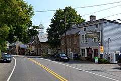
The Hillsboro Historic District in Hillsboro, Virginia is a historic district that was listed on the National Register of Historic Places in 1979. In 1979 it included 40 contributing buildings over its 60-acre (24 ha) area.[1] Hillsboro was established as "The Gap", but in 1802 the town became Hillsborough. In 1880 the present spelling began to be used. Hillsboro is laid out in a roughly linear fashion along Virginia State Route 9, with lots in the historic district characteristically deep and relatively narrow. The pre-1835 houses in the district are characterized by two-story stone construction with gable roofs. Few new houses were built until the late 19th century, when Victorian houses were built, some with Eastlake detailing.[3]
The Hillsboro Historic District was placed on the National Register of Historic Places on May 7, 1979.[1]
References
- 1 2 3 National Park Service (2009-03-13). "National Register Information System". National Register of Historic Places. National Park Service.
- ↑ "Virginia Landmarks Register". Virginia Department of Historic Resources. Retrieved 5 June 2013.
- ↑ Virginia Historic Landmarks Commission (August 1978). "National Register of Historic Places Inventory - Nomination Form: Hillsboro Historic District amendment" (PDF). National Park Service. Retrieved 18 September 2011.

