Hill people
Hill people is a general term for people who live in hills and mountains. There are hill people around the world, many of whom live in stone houses and herd goats, sheep or camelids or have small farms. Musical instruments of the hill people, such as various forms of bagpipe and horn, are notable for their ability to be heard at great distances. Hill people are often divided into tribes that have a tradition of feuding among each other while resisting control by any central government. Often the hill people are minorities in their countries, and are divided by political borders.
Africa
Drakensberg

The Drakensberg are the highest mountain range in Southern Africa, rising up to 3,482 metres (11,424 ft) in height. The people of these mountains are mostly Bantu-speaking people who moved into the area from the north a thousand years ago, displacing the original Khoisan people. They include the Swazi, Xhosa and Zulu. Traditionally these people lived by cattle herding and small-scale farming, growing crops such as sorghum, maize, corn, pumpkins, beans and vegetables.[1]
At the time the Europeans reached this part of South Africa (around 1830), the Zulu were temporarily in the ascendancy after a series of wars between the people of the region.[2] The region is divided between South Africa, Lesotho and Swaziland, but the people move relatively freely between these states.[1]
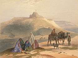
Ethiopian Highlands
.jpg)
Ethiopia has a high central plateau that varies from 1,800 to 3,000 m (5,900 to 9,800 ft) above sea level, with the highest mountain reaching 4,533 m (14,872 ft). Near the equator but high up, the climate is temperate all year round. The heavy rains from June until mid-September feed the Blue Nile, which waters Egypt.[3]
The country's population is highly diverse. Most of its people speak Afro-Asiatic languages of the Cushitic or Semitic branches. The former includes Oromiffa, spoken by the Oromo people, and Somali, spoken by the Somali people; the latter includes Amharic, spoken by the Amhara people, and Tigrinya, spoken by the Tigray-Tigrinya people. Together, these four groups make up about three-quarters of Ethiopia's population. Other Afro-Asiatic languages with a significant number of speakers include the Cushitic Sidamo, Afar, Hadiyya and Agaw languages, as well as the Semitic Gurage, Harari, Silt'e and Argobba tongues.[4] Principal crops include coffee, pulses (e.g. beans), oilseeds, cereals, potatoes, sugarcane, and vegetables. Many of the people traditionally herded cattle, goat or sheep.[5]
The Ethiopian state is ancient, dating back to at least the Aksumite Empire (which officially used the name "Ethiopia" in the 4th century) and its predecessor state, D`mt (with early 1st millennium BC roots). Despite two attempts at conquest by the Italians, the country has remained independent for almost all its history. The Coptic Christian church has a long history in Ethiopia. It was founded in 316 AD by Meropius, a Christian philosopher from Tyre.[6]
Atlas and Rif

The Atlas is a mountain range across a northern stretch of Africa extending about 2,400 km (1,500 mi) through Morocco, Algeria, and Tunisia, or the Maghreb. The highest peak is Jbel Toubkal, with an elevation of 4,167 metres (13,671 ft) in southwestern Morocco. The second highest mountain is the M'Goun of 4,071 metres (13,356 ft).
The population of the Atlas Mountains are mainly Berber tribes, speakers of an Afro-Asiatic language, including the Kabyle, Chaoui, Mozabite, Riffians, Chleuh, Sous, Tuareg and Zenata. Although nominally subject at times to Carthage, the Roman Empire, the Fatimid dynasty of Egypt (who originated in this area), the Ottoman Turks and more recently the French, for most of their history the tribes of the Atlas mountains have effectively been independent.
Most Berbers are farmers, living in mountains relatively close to the Mediterranean coast, but the Tuareg and Zenaga of the southern Sahara are nomadic. The Berbers are sometimes treated as minorities in their countries, which are dominated by their Arabic-speaking relatives nearer to the coast.[7]
Europe
Pyrenees and Galicia

The Pyrenees are a range of mountains in southwest Europe that form a natural border between France and Spain. Lower mountains extend to the west into Galicia. The inhabitants speak Spanish, French, Catalan (in Catalonia and Andorra), and the Basque language. A few speak the Occitan language (the Gascon and Languedocien dialects in France and the Aranese dialect in the Aran Valley), and Aragonese.
It is thought that Basque people are a remnant of the early inhabitants of Western Europe. Basque tribes were already mentioned in Roman times by Strabo and Pliny, including the Vascones, the Aquitani and others. Their language is quite distinct from the Indo-European languages spoken in most of Europe, and possibly (although there is much debate) is related to Northeast Caucasian languages.[8] The Euskadi Ta Askatasuna or ETA is an illegal and armed Basque nationalist, terrorist and separatist organisation. Founded in 1959, it evolved from a group advocating traditional cultural ways to a paramilitary group demanding Basque independence.[9]
Alps

The Alps are one of the great mountain ranges of Europe. They stretch from Austria and Slovenia in the east, through Italy, Switzerland, Liechtenstein and Germany, to France in the west. The highest mountain is Mont Blanc, at 4,808 metres (15,774 feet), on the Italian–French border. The people of the Alps speak German, French, Italian, Slovene and Romansh. The German spoken in the German speaking part of Switzerland is a range of Swiss dialects.
Early Alpine tribes included the Helvetii and Alemanni. The Swiss Confederacy was an alliance among the valley communities of the central Alps founded by three cantons in 1291, later expanding to form the nucleus of modern Switzerland. Disciplined Swiss mercenaries armed with pikes gained a formidable reputation during the perennial European wars of the Middle Ages.
In the Swiss peasant war of 1653 the people rose up against the nobles and authorities. Although defeated, the revolt resulted in reforms that prevented the rise of absolutism as in other parts of Europe. The Swiss to this day have an unusual form of government where almost all major decisions are voted upon by the people.
The Alpine people have at times been subject in part or whole to neighboring countries, but many in the central Alps maintained the independence of their communities until 1848, when they combined into the federal state of Switzerland.[10]
The Italian Alps also contain a diverse array of mountain cultures and valley towns. In the southern Italian Alps, the Camuni people are famous for their rock drawings in Valcamonica.
Apennines

The Apennine mountains in Italy were home to pre-Roman cultures and Italic tribes for centuries, most notably the Etruscans, the mountainous peoples known as the Praetutii and Picentes, the Vestini, the Aequi, and Oscan-Umbrian tribes, including the Sabines, Umbri, Samnites, Marrucini, Hernici, Marsi, and Paeligni. The Apennines were notably the birthplace of pre-Roman Apennine culture, a cultural complex throughout the Apennines in central and southern Italy spanning much of the Bronze Age. The people of the Apennine culture were cattle herdsmen grazing their ungulates over the meadows and groves of mountainous central Italy, though their range was not confined to the hills. These tribes lived in small hamlets located in defensible places. On the move between summer pastures they built temporary camps or lived in caves and rock shelters. Their pottery has been found on the Capitoline Hill in Rome.
The Apennines stretch from modern day Liguria to Reggio Calabria, and mountain towns and communities can be found throughout the whole of the Apennine mountain range. However, certain regions, especially Abruzzo, Molise, eastern Lazio, Umbria, and Marche, are home to larger, more prototypical mountain cultures, and these cultures often remained largely isolated from the wider Italian peninsular culture until modern times. The region of Abruzzo in particular is well known for its mountain shepherd culture, with Teramo, Chieti, and L'Aquila being the most mountainous of Abruzzo's provinces. Abruzzo holds many of Italy's best-preserved and most beautiful medieval and Renaissance hill towns. The region is also the location of Gran Sasso and Abruzzo National Park, a haven for mountain-dwelling fauna such as the Abruzzo chamois, Italian wolf, and the Apennine brown bear.
Shepherd culture, which often thrives in mountainous regions, has significantly influenced the cultures of the Abruzzese peoples and other central Apennine peoples. For instance, bagpipes known as zampogna, traditionally made from sheep or goat skin or organs, are prominent in traditional Abruzzese and central and southern Apennine folk music. Sheep dishes such as arrosticini are also common in Abruzzese cuisine and central Apennine cuisine. The region is also home to mountain dogs and sheep dogs such as the Pastore Maremmano-Abruzzese, Italian Shepherd, and Abruzzese Mastiff, dog breeds used to protect sheep and livestock from predators in mountainous terrain. Further north, in Emilia-Romagna, the shepherds in the Apennines near Reggio Emilia developed the shepherd dog breed Cane Lupino del Gigante. The Piccolo Segugio dell'Appennino is another Apennine dog breed found throughout the mountain range.
Scottish Highlands

The Scottish Highlands include the rugged and mountainous regions of Scotland north and west of the Highland Boundary Fault. They are inhabited by people of the Scottish Gaelic culture, although most now speak English. Traditionally the people lived by crofting, or small-scale farming, growing crops such as oats, barley and kale, and supplemented their diet with fish and red deer.
On festive occasions, the people eat haggis, made from a sheep's heart, liver and lungs, minced with onion, oatmeal, suet, spices, and salt, mixed with stock, and boiled in the animal's stomach for three hours. The haggis was immortalized by the lowland poet Robert Burns in his Address to a Haggis.[11]
The Scottish clans have a tradition of feuding among each other and resisting the authority of the central government based in the lowland city of Edinburgh.[12] The Highland regiments went to war wearing tartan kilts accompanied by bagpipe players – a sight and sound calculated to strike fear into the hearts of their enemies.[13]
Balkans
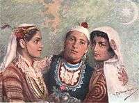
The Balkan Mountains run 560 km from the Vrashka Chuka Peak on the border between Bulgaria and eastern Serbia eastward through central Bulgaria to Cape Emine on the Black Sea. The highest peaks of the Stara planina are in central Bulgaria. The highest peak is Botev (2,376 m).
Lying between Austria, Italy, Turkey and the Ukraine, the Balkans have had a turbulent history. At different times different parts of the Balkans were controlled by the Macedonian, Roman, Byzantine, Ottoman and Austrian empires.
The Balkans are home to people speaking Slavic languages (Serbs, Croats, Bulgarians and Macedonians), Romanian (related to Italian), Turkish, Greek, Albanian and other languages. Through its history many other ethnic groups with their own languages lived in the area, among them Thracians, Illyrians, Romans, Pechenegs, Cumans, Avars, Celts, Germans and various Germanic tribes. In addition to language, the people are divided by religion, adhering to the Roman Catholic, Greek Orthodox and Moslem religions among others.[15]
Asia
Caucasus

The Caucasus Mountains is a range between the Black sea and the Caspian sea. It is home to Europe's highest mountain (Mount Elbrus). Modern countries of the Caucasus are Chechnya, Ingushetia, Dagestan, Adyghea, Kabardino-Balkaria, Karachay–Cherkessia, North Ossetia, Krasnodar Krai and Stavropol Krai, all parts of the Russian Federation, and the independent countries of Georgia (including the disputed Abkhazia and South Ossetia), Armenia, Azerbaijan and Turkey.
The people of these mountains have very diverse origins, with cultures influenced by periods of Turkic, Iranian and Russian control. Some, including the Georgians and Armenians, are mostly Christian, while others are Muslim in religion.[16]
Hindu Kush and Balochistan
The Hindu Kush is a mountain range located between Afghanistan and Pakistan. It is the westernmost extension of the Pamir Mountains, the Karakoram Range, and is a sub-range of the Himalayas. Lower mountains including the Sulaiman Range extend south to the Arabian Sea.
The people of this region generally speak Indo-Iranian languages such as Pashto, Balochi, and languages of the Dardic and Nuristani groups. The Brahui people speak a Dravidian language. There are many distinct tribes. The history of the region has been turbulent, lying in the path of invasions from the Persians, the Greeks under Alexander the Great, the Arabs, Mughals and British. Given the rugged geography, central governments have generally had limited control over the tribes, a situation that persists to this day.[17]
Pamirs
The Pamir Mountains are in Central Asia, formed by the junction of the Tian Shan, Karakoram, Kunlun, and Hindu Kush ranges. They are among the world's highest mountains and in Victorian times they were known as the 'Roof of the World'. The people of this region are mostly Turkic people, and speak Pamir languages, Tajik (closely related to Persian), Uzbek and Kyrgyz.
Himalayas

The Himalayas lie between the Indian subcontinent and the Tibetan Plateau, thrown up by the collision of two tectonic plates. They include world's highest peaks including Mount Everest and K2. The Himalayas stretch across Bhutan, China, India, Nepal, Pakistan and Afghanistan.[18]
People have filtered into the mountains from the northern plateau and from the southern plains and intermingled. They mostly speak Tibeto-Burman languages such as Gurung and Nepal Bhasa or Indo-Aryan languages such as Garhwali, Shina, Kashmiri, Dogri, Pahari (which means "language of the mountain people"), Kumaoni, Nepali and Asamiya.[19] The Gurkha people of Nepal are well known for their history of bravery and strength, and still serve in foreign armies such as the British Army's Brigade of Gurkhas and the Indian Army's Gorkha regiments.[20]
Fruit, vegetables and sheep flourish in the fertile valley of Kashmir. The people have evolved the unique and famous Kashmiri cuisine with Iranian, Indian and Turkic origins. While the stricter Hindus may restrict themselves to rice with vegetables, curd, milk and fresh fruit, the Muslims eat pilaf and mutton stuffed with spices, apricots stuffed with mutton, roast kid, fish and honey rice.[21]
Further east, a typical Nepalese meal includes Dal, a spicy lentil soup, served over bhat (boiled rice) with tarkari (curried vegetables) together with achar (pickles) or chutni (spicy condiment made from fresh ingredients). In the hills of Nepal, people enjoy their own kind of music, playing sarangi (a string instrument), madal (a hand drum) and flute. They also have many popular folk songs known as lok geet and lok dohari.[22]
Southeast Asian Massif and Zomia

The mainland portion of Southeast Asia consists of Cambodia, Laos, Burma, Thailand and Vietnam, and Assam in India. The hills of this region include tribes of Tibeto-Burman peoples including the Akha, Bodo-Kachari, Lahu, Karen, Hmong Mien, Mizo (Mizo is under the sub-group of Zomi )and Lisu. It is thought that they drifted down into the area from Tibet.
Many of the tribes are spread across more than one country - the Karen people live in Burma and Thailand,
The Zomi people live in the Chin State, Sagaing Region of Burma and the Mizoram State, Manipur in India and Bangladesh. The Zomi are known as Chin-Kuki-Mizo. Their language is common or overlap approximately more than 40%. They live under three country in India, Burma and Bangladesh.
The Akha people live in small villages among the mountains of China, Laos, Burma, and northern Thailand. They often retain their traditional way of life but are under increasing pressure to do so. As minorities, they tend to be less well off than the majority of people in the countries where they live.
Interesting theorisations about the hill people from this region include the notions of "Southeast Asian Massif" and "Zomia". Southeast Asian Massif was proposed by Laval University anthropologist Jean Michaud in 1997. This high region extending eastward from the Himalayas and the Tibetan Plateau covers more than 2.5 million square kilometers and comprises nearly one hundred million marginal peoples. This large area is inside the fringe of ten states and at the middle of none, stretching across the standard regional designations (South Asia, East Asia, and Southeast Asia); along with its ecological diversity and its relation to states, it arouses a lot of interest. It stands for an original entity of study, a type of international Appalachia, and a different way in which to study regions as illustrated in Michaud's "Historical Dictionary of the Peoples of the Southeast Asian Massif" (Scarecrow Press, 2006). Zomia (geography) is a geographical term coined in 2002 by historian Willem van Schendel of the University of Amsterdam to refer to the huge massif of mainland Southeast Asia that has historically been beyond the control of governments based in the population centers of the lowlands. The massif arose during the Alpine orogeny, when the African, Indian and Cimmerian Plates, and smaller Asian terranes, collided with that of Eurasia. The name is from Zomi, a term for highlander common to several related Tibeto-Burman languages spoken in the India-Bangladesh-Burma border area.
The exact boundaries of Zomia differ among scholars: all would include the highlands of north Indochina (north Vietnam and all Laos,) Thailand, the Shan State of northern Burma, and the mountains of Southwest China, others extend the region as far west as Tibet, north India, Pakistan, and Afghanistan. These areas share a common elevated, rugged terrain, and have been the home of ethnic minorities that have preserved their local cultures by residing far from state control and influence. Other scholars have used the term to discuss the similar ways that Southeast Asian governments have handled minority groups. Once such is Yale University Professor James C. Scott, who address the issue in his 2009 book The Art of Not Being Governed: An Anarchist History of Upland Southeast Asia. From the Preface:
“[Hill tribes] seen from the valley kingdoms as “our living ancestors,” “what we were like before we discovered wet-rice cultivation, Buddhism, and civilization” [are on the contrary] best understood as runaway, fugitive, maroon communities who have, over the course of two millennia, been fleeing the oppressions of state-making projects in the valleys — slavery, conscription, taxes, corvée labor, epidemics, and warfare.”
Thailand
A 2013 newspaper article from the Bangkok Post said that "Nearly a million hill people and forest dwellers are still treated as outsiders, criminals even, since most live in protected forests. Viewed as national security threats, hundreds of thousands of them are refused citizenship although many are natives to the land."[23]
Vietnam
The Central Highlands of Vietnam have traditionally been populated by a majority of hill tribes, all of who are culturally distinct from the ethnic Vietnamese population of the lowlands. Collectively known as Montagnard (French for "mountain people"), they are also referred derogatorily as mọi (literally "savage" in Vietnamese).[24] While Vietnamese expansion into the Central Highlands dates back to the French colonial period, large-scale settlement did not occur until after the Vietnam War. Today, the Montagnards form a minority in much of the Central Highlands, with the exception of a few areas.[25]
Local Vietnamese assisted French colonial armies in suppressing rebellions among the hill tribes during the early 20th century, with some calls for completely ridding the Central Highlands of the "uncivilized" hill tribes for large-scale Vietnamese and French settlement. Political and economic barriers prevented hill tribes from obtaining high levels of education and entering commerce, although outright legal discrimination against Montagnards was made illegal by the colonial government.[26] During the Vietnam War, American Special Forces trained many hill tribes in Vietnam to stop Viet Cong activity in the region and to prevent them from aligning with the Viet Cong.[27]
New Guinea highlands
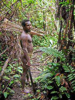
New Guinea, located just north of Australia, is the world's second-largest island. A central east-west mountain range dominates the geography of New Guinea and contains the highest mountains in Oceania, rising up to 4884 m high. The island is populated by very nearly a thousand different tribal groups and a near-equivalent number of separate languages, which makes New Guinea the most linguistically diverse area in the world. They fall into one of two groups, speakers of the Papuan languages and later arrivals who speak Austronesian languages.
The gardens of the New Guinea Highlands are ancient, intensive permacultures, adapted to high population densities, very high rainfalls (as high as 10,000 mm/yr (400 in/yr)), earthquakes, hilly land, and occasional frost. The people use complex mulches, crop rotations and tillages on terraces with complex irrigation systems. Native gardeners are as or more successful than most scientific farmers in raising certain crops. Early garden crops – many of which are indigenous – included sugarcane, Pacific bananas, yams, and taro, while sago and pandanus were two commonly exploited native forest crops. Today's staples – sweet potatoes and pigs – are later arrivals.[28]
The people of New Guinea were traditionally warlike, with constant feuds over territory, although violence has greatly reduced in recent years.[29]
Americas
Appalachians
The Appalachian Mountains are a vast system of mountains in eastern North America. Before the Europeans reached the area around 1650, the mountains were inhabited by Algonquian people; speakers of Iroquoian languages such as the Cherokee; and Siouan people such as the Occaneechi, Tutelo and Monacan. The European invaders were ruthless in their treatment of these hill people, many of whom they killed or forced to move into unfamiliar territory to the west. Many others died of diseases such as smallpox introduced from Europe. Few of the early inhabitants remain.[30]
Some of the people who live in the mountains today retain distinct cultural characteristics. The Hatfield–McCoy feud (1878–1891) involved two warring families of the West Virginia–Kentucky backcountry along the Tug Fork river, off the Big Sandy River. Between 1880 and 1891, the feud claimed more than a dozen members of the two families.[31] The 1972 film Deliverance depicted the hill people as backward and hostile to outsiders, and the film implies some of them are inbred – a stereotype of the "Hillbilly" culture.[32]
Rocky Mountains

The Rocky Mountains stretch more than 4,800 kilometers (3,000 mi) from northernmost British Columbia, in Canada, to New Mexico, in the United States. The range's highest peak is Mount Elbert in Colorado at 14,440 feet (4,400 meters) above sea level.
As the Europeans continued to move west, they took most of the lands of the people who lived in the Rockies, forcing the Ute, Navajo, Hopi, Apache, Yaqui and other tribes to assimilate or move onto reservations. Some adapted to farming or sheep herding, but they are the most impoverished of all ethnic groups in the USA.
The Ancient Pueblo peoples who lived in the present-day Four Corners area of the Southwestern United States were noted for their distinctive pottery and dwelling construction styles. The cultural group is often referred to as the Anasazi. Some of their unusual cliff dwellings still stand today.[33]
Western United States
Ishi (c. 1860 – March 25, 1916) was presumed to be the last member of the Yahi people, the last surviving group of the Yana people in the U.S. state of California. What is now the Western United States has long been home to indigenous peoples of the Great Basin, who live mainly in desert regions and share characteristic with hill people.
Mexican Sierras


The American Cordillera in Mexico includes the Sierra Madre Occidental, Sierra Madre Oriental and Sierra Madre del Sur. The mountain valleys have a temperate climate and fertile soil, and were the cradles of Mesoamerican civilizations that flourished long before Europeans discovered the area, including the Olmec, Teotihuacán, Toltec, Aztec, Zapotec and Mixtec cultures. The bold patterns and deep saturated colors of the Mesoamerican artists are echoed in modern Mexican art and architecture.
After the Spanish invasion of 1519, led by Hernán Cortés, most people eventually adopted the Spanish language, but there remain many groups who retain their original languages and live traditional ways of life. These include the Nahuatl, Zapotec, Mixtec, Otomí, Tzotzil, Tzeltal, Mazahua, Mazateco, Chinantec, Purépecha, Mixe and Tlapanec.[34]
The traditional Mexican diet is based on maize, beans, chili peppers, tomatoes, cactus and other native plants, supplemented by iguana, rattlesnake, fish and venison. Mexican cuisine today is one of the most rich and varied in the world.[35] Before the Spanish came, the inhabitants of the land used drums, flutes, maracas, seashells and voices to make music and dances. This ancient music is still played in some parts of Mexico.[36]
Andes
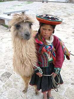
The Andes form the world's longest exposed mountain range, a continuous chain of highland along the western coast of South America. The range is over 7,000 km (4,300 mi) long, 200–700 km (120–430 mi) wide (widest between 18° to 20°S latitude), and of an average height of about 4,000 m (13,000 ft).
Before the Spanish invasion led by Francisco Pizarro in 1532 the Andes were primarily inhabited by Quechua peoples such as the Inca, Chancas, Huancas and Cañari in the north, and Aymaras further south. Their economy was based on the potato crop, which originated in the area, and the llama and alpaca, used for their wool and meat. Unlike most mountain people, the inhabitants of the Andes appear to have been generally unwarlike.[37]
References
- 1 2 Mesthrie, Rajend (1995). Language and Social History: Studies in South African Sociolinguistics. p. 49. ISBN 0-86486-280-6.
- ↑ Morris, Donald R. (1998). The Washing of the Spears: The Rise of the Zulu Nation. Cambridge: Da Capo Press. pp. 692 Pages. ISBN 0-306-80866-8.
- ↑ "Ethiopia: Drought intensifies during corn and sorghum harvest" ReliefWeb
- ↑ "Country Level". 2007 Population and Housing Census of Ethiopia. CSA. 13 July 2010. Retrieved 18 January 2013.
- ↑ Ethiopia: A Model Nation of Minorities Berhanu Abegaz. Retrieved 15 December 2008
- ↑ Marcus, Harold G. (2002). A History of Ethiopia (updated ed.). Berkeley: University of California Press. ISBN 0-520-22479-5.
- ↑ Brett, Michael; & Fentress, Elizabeth (1997). The Berbers (The Peoples of Africa). ISBN 0-631-16852-4. ISBN 0-631-20767-8 (Pbk).
- ↑ A Basque Encyclopedia and other cultural and historical funds (in Spanish, though it can be searched in English, Basque and French)
- ↑ "ETA claims responsibility for 17 attacks". CNN. 2000-11-19. Retrieved 2010-05-04.
- ↑ Dictionnaire historique de la Suisse (DHS), Editions Gilles Attinger, Hauterive, ISBN 2-88256-133-4 (2002-)
- ↑ Dickson Wright, Clarissa (1998). The Haggis: A Little History. Pelican Publishing Company. ISBN 1-56554-364-5.
- ↑ Adam, Frank; Innes of Learney, Thomas (1970). The Clans, Septs & Regiments of the Scottish Highlands (8th ed.). Edinburgh: Johnston and Bacon.
- ↑ royalhighlanders.co.uk
- ↑ Illustration from Fox, Frank, Sir Bulgaria (1915) London: A. and C. Black, Ltd., p. 25. e-book #22257 in Project Gutenberg
- ↑ Jelavich, Barbara (1983-07-29). History of the Balkans. Cambridge University Press.
- ↑ Caucasus and Iran entry in Encyclopædia Iranica
- ↑ Banuazizi, Ali and Myron Weiner (eds.). 1994. The Politics of Social Transformation in Afghanistan, Iran, and Pakistan (Contemporary Issues in the Middle East), Syracuse University Press. ISBN 0-8156-2608-8
- ↑ Yang, Qinye (2004). Himalayan Mountain System. ISBN 978-7-5085-0665-4. Retrieved 2007-08-07.
- ↑ Anthologia anthropologica. The native races of Asia and Europe; by James George Frazer, Sir; Robert Angus Downie
- ↑ Brigade of Gurkhas website
- ↑ Godden, Rumer (1953). Kingfishers Catch Fire. London: MacMillan.
- ↑ National Geographic Country Profile: Nepal
- ↑ Time ripe for whole new take on 'Thainess'
- ↑ H. Maître (1909) Les Régions Moi du Sud-lndochinois: Le plateau de Darlac
- ↑ General Statistics Office (1996): Population Data of Sparsely Populated Areas in Vietnam. Statistical Publishing House, Hanoi
- ↑ AOM Gougal F 03.79: Annexe du rapport politique de l'Annam, 9/1937
- ↑ Kelly, Francis John (1989) [1973]. History of Special Forces in Vietnam, 1961-1971. Washington, D.C.: United States Army Center of Military History. pp. 6–7. CMH Pub 90-23.
- ↑ Diamond, Jared. Collapse. (German translation), Frankfurt 2005, p. 350.
- ↑ Lynne Armitage. "Customary Land Tenure in Papua New Guinea: Status and Prospects" (PDF). Queensland University of Technology. Retrieved 2005-07-15.
- ↑ Snipp, C. M. American Indians: The first of this land. New York: Russell Sage Foundation, 1989.
- ↑ Rice, Otis K (1982). The Hatfields and McCoys. The University Press of Kentucky. pp. 150 pages. ISBN 0-8131-1459-4.
- ↑ Hill people at the Internet Movie Database
- ↑ An Early Population Explosion on the Colorado Plateau
- ↑ Los pueblos indígenas de México, Comisión Nacional para el Desarrollo de los Pueblos Indígenas
- ↑ Long-solís, Janet; Vargas, Luis Alberto (2005). Food culture in Mexico. Westport, Conn.: Greenwood Press. ISBN 978-0-313-32431-4.
- ↑ National Geographic World Music entry - Mexico
- ↑ Mariátegui, José Carlos, Siete ensayos de interpretación de la realidad peruana, Ediciones Era, 1979, p 25.