Hiidenvesi
| Hiidenvesi | |
|---|---|
 | |
| Location | Uusimaa |
| Coordinates | 60°22′30″N 024°11′30″E / 60.37500°N 24.19167°ECoordinates: 60°22′30″N 024°11′30″E / 60.37500°N 24.19167°E |
| Catchment area | Karjaanjoki |
| Basin countries | Finland |
| Surface area | 29.09 km2 (11.23 sq mi) |
| Average depth | 6.68 m (21.9 ft) |
| Max. depth | 29.38 m (96.4 ft) |
| Water volume | 0.195 km3 (158,000 acre·ft) |
| Shore length1 | 100.87 km (62.68 mi) |
| Surface elevation | 32 m (105 ft) |
| Frozen | December–April |
| Islands | Papinsaari |
| Settlements | Vihti, Lohja |
| References | [1] |
| 1 Shore length is not a well-defined measure. | |
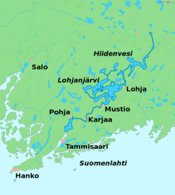
Hiidenvesi is the second largest lake in the Uusimaa region in Finland. The biggest part of the lake is located in the municipality of Vihti and smaller parts in the town of Lohja. The lake drains through the Väänteenjoki River into the lake Lohjanjärvi and the both lakes are part of the Karjaanjoki (Swedish: Svartån) basin that drains into the Gulf of Finland.[1]
See also
References
- 1 2 Hiidenvesi in the Jarviwiki Web Service. Retrieved 2014-03-02. (English)
External links
-
 Media related to Lake Hiidenvesi at Wikimedia Commons

Hiidenvesi in Retlahti, Pusula, Lohja. To the south.
This article is issued from Wikipedia - version of the 9/4/2015. The text is available under the Creative Commons Attribution/Share Alike but additional terms may apply for the media files.