Highways in the Philippines

Highways in the Philippines include roads that can be classified into six divisions: the Pan-Philippine Highway, controlled-access highways, regional highways, provincial highways, and the secondary city and municipal avenues and roads, including Metro Manila's arterial road network .
Pan-Philippine Highway
The Pan-Philippine Highway, also known as the Maharlika Highway (AH26) is a 3,517 km (2,185 mi) network of roads, bridges, and ferry services that connect the islands of Luzon, Samar, Leyte, and Mindanao in the Philippines, serving as the country's principal transport backbone. The Maharlika Highway commences in Laoag then skirts eastward toward Pagudpud and the Claveria coast towards Cagayan via the Patapat Viaduct. It then travels south along the Cagayan Valley Road towards Tuguegarao, the capital of Cagayan province. The highway then goes fairly straight, passing through the provinces of Isabela, Nueva Vizcaya, Nueva Ecija, and Bulacan, where, in the area near Guiguinto, it merges with the North Luzon Expressway (NLEX), en route to Metro Manila. In Metro Manila, the highway passes through either one of the following routes: the southeast route along Epifanio de los Santos Avenue (EDSA) from the Balintawak Interchange of NLEX to the Magallanes Interchange, or southwest route via EDSA to Samson Road, C-4, Marcos Road, Bonifacio Drive, Roxas Boulevard and turning east back on EDSA towards the Magallanes Interchange. The highway then travels south along the South Luzon Expressway (SLEX), and merges with the National Highway in Santo Tomas, Batangas, following the route to San Pablo, Laguna and Lucena, Quezon. It passes through Quezon, Camarines Norte, Camarines Sur, Albay, and Sorsogon provinces. It ends in Matnog town, Sorsogon.[1] Then through ferry, it goes straight through the Samar and Leyte provinces, then a ferry is again passed, to the island of Mindanao. In Mindanao, it passes through the provinces of Surigao del Norte, Agusan, Davao, Davao del Sur, South Cotabato, Sultan Kudarat, Maguindanao, Lanao del Sur, Lanao del Norte, and Zamboanga del Sur, where it ends.[1]
Tollways and expressways
In the Philippines, there are seven controlled-access highways, all located on Luzon island:
| Road Image | Expressway | Location | Notes |
|---|---|---|---|
 |
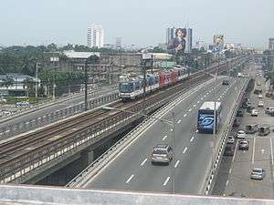
North Luzon Expressway (R-8) |
Region 3 and National Capital Region in Luzon | The North Luzon Expressway (NLE or NLEx), formerly called North Diversion Road, is a 4 to 8-lane limited-access toll expressway that connects Metro Manila to the provinces of the Central Luzon region in the Philippines. It is one of the two branches of the Radial Road 8 (R-8) of Metro Manila (Quirino Highway is the other).
The expressway begins in Quezon City at a cloverleaf interchange with EDSA: a logical continuation of Andres Bonifacio Avenue. It then passes through Quezon City, Caloocan, and Valenzuela in Metro Manila. Meycauayan, Marilao, Bocaue, Balagtas, Guiguinto, Malolos, Plaridel, and Pulilan in Bulacan. San Simon, San Fernando, Mexico and Angeles in Pampanga. The expressway currently ends in Mabalacat and merges with the MacArthur Highway, which continues northward into the rest of Central and Northern Luzon. A planned spur route from the San Simon interchange connecting to the existing Subic-Tipo Highway has been temporarily postponed, because the Spur/NLE exit currently serves as the connection between the expressway and the Subic-Clark-Tarlac Expressway and there is a proposed direct interchange between the North Luzon Expressway and the Subic-Clark-Tarlac Expressway,[2] the latter serving as a direct link between Subic and Clark. The interchange is located at least 3 km north of Sta. Ines Exit. The expressway, including Andres Bonifacio Avenue, has total length of 88 kilometers. The expressway segment has a length of 84 kilometres. Originally controlled by the Philippine National Construction Corporation or PNCC, operation and maintenance of the NLEx was transferred in 2005 to the Manila North Tollways Corporation, a subsidiary of Metro Pacific Investments Corporation (formerly, it was the subsidiary of the Lopez Group of Companies). A major upgrade and rehabilitation has been completed in February 2005 and the road has now similar qualities as a modern French tollway. The main contractor of the rehabilitation work was Leighton Contractors Pty. Ltd (Australia) with Egis Projects, a company belonging to the French Groupe Egis as the main subcontractor for the toll, telecommunication and traffic management systems. To help maintain the safety and quality of the expressway, various rules are in effect, such as restricting the left lane to passing vehicles only and banning overloaded trucks. The tollway has two sections: an open section and a closed section.[2] The open section (within Metro Manila) charges a flat toll based on vehicle class and is employed to reduce the number of toll barriers (and associated bottlenecks) within the metropolis. The closed section is distance-based, charging based on the class of vehicle and distance traveled. Class 1 vehicles can use an electronic toll collection system (called EC Tag) to reduce wait times and congestion at toll barriers. A prepaid magnetic card (the NLE Badge) is provided as an alternative payment for class 2 and 3 vehicles. Both systems connect to accounts that can be replenished in various ways. |
 |
South Luzon Expressway (R-3) |
CALABARZON and NCR in Luzon | The South Luzon Expressway (SLEX), also nicknamed South Superhighway (SSH), and officially known as Radial Road 3 or R-3, is a network of two expressways that connects Metro Manila to the provinces of the CALABARZON region in the Philippines. The first expressway is the Metro Manila Skyway System, operated jointly by the Skyway Operation and Management Corporation (SomCo) and Citra Metro Manila Tollways Corporation (CMMTC). The second expressway, the South Luzon Tollway or Alabang-Calamba-Sto.Tomas Expressway (ACTEx), is jointly operated by the South Luzon Tollway Corporation, a joint venture of the PNCC and the Malaysian company MTD Capital Berhad and the Manila Toll Expressway Systems, Inc. (MATES).
The expressway starts in Manila's Paco District at Quirino Avenue and passes through the following cities and municipalities: Manila, Makati, Pasay, Parañaque, Taguig and Muntinlupa in Metro Manila, San Pedro, Biñan, Carmona in Cavite, the transverses again to Biñan, Santa Rosa, Cabuyao and Calamba in Laguna it ends in Santo Tomas, Batangas. In 2006, the South Luzon Tollway segment underwent rehabilitation through the SLEX Upgrading and Rehabilitation Project, which rehabilitates and expands the Alabang Viaduct as well as the road from Alabang to Calamba, and eventually connect the expressway to the Southern Tagalog Arterial Road to Santo Tomas, Batangas. |
 |
Metro Manila Skyway (R-3) |
Metro Manila | The Metro Manila Skyway is a 6-lane expressway on the top of SLEX connecting Makati and Muntinlupa. It starts from the SLEX-Gil Puyat Avenue Interchange, and it passes through the cities of Makati, Taguig and Pasay, and ends in the Alabang Interchange in Muntinlupa. |
 |
Subic-Clark-Tarlac Expressway (R-8) |
Region 3 | The Subic-Clark-Tarlac Expressway, or SCTEX, is a 2-4 lane highway connecting the Subic Bay Freeport Zone with Tarlac City, passing through the heart of the Hacienda Luisita, the biggest farmland in the Philippines. The Road is the continuation of the Radial Road 8 from the terminus of NLEX to Tarlac. |
 |
Southern Tagalog Arterial Road (R-3) |
Batangas | The Apolinario Mabini Superhighway, or the STAR Tollway, is a 2-4 lane expressway connecting Santo Tomas, Batangas to Batangas City, letting the vehicles from the SLEX access the Batangas Port. It is the extension of the Radial Road 3 in CALABARZON. |
 |
Manila-Cavite Expressway (R-1) |
NCR and CALABARZON | The Manila-Cavite Expressway, also known as the Coastal Road, Aguinaldo Boulevard and CAVITEX is an 8-16 lane highway connecting the Metro Manila to Cavite, passing through the coast of the Manila Bay. The Road will then follow a reclamated route over the bay as a 4-lane expressway, eventually ending in the covelandia resort in Kawit, Cavite. |
 |
Bataan Provincial Expressway | Bataan Province | The Bataan Provincial Expressway, also known as the Death March Memorial Road, Roman Superhighway and BPEX, is the main thoroughfare of the Bataan Province. |
Manila Arterial Road Network
Metro Manila's arterial road network consists of the national roads, the six circumferential roads, and the ten radial roads, as well as the other major roads connecting the cities of Manila, Quezon City, North and South Caloocan, Valenzuela, Malabon, Navotas, Pasay, Parañaque, Las Piñas, Taguig, Muntinlupa, Marikina, Pasig, Mandaluyong, Makati, Pateros, and San Juan as well as the surrounding provinces.[3][4]
Metro Cebu and Province Highways


The following are some major roads and streets in Cebu:
- Cebu South Coastal Road (Cebu City and Talisay City)
- Sergio Osmeña Boulevard (Cebu City)
- General Maxilom Avenue (Cebu City)
- Gov. M. Cuenco Avenue (Cebu City)
- M.J. Cuenco Avenue (Cebu City)
- Gorordo Avenue (Cebu City)
- Pope John Paul II Avenue (formerly known as Juan Luna Avenue and San Jose dela Montana Avenue) (Cebu City)
- Manuel L. Quezon National Highway (Lapu-Lapu)
- Maximo V. Patalinghug Jr. Avenue (Lapu-Lapu)
- General Aviation Road (Lapu-Lapu)
- Mactan Circumferential Road (Lapu-Lapu and Cordova)
- Ouano Avenue (Mandaue)
- United Nations Avenue (Mandaue)
- A.C. Cortes Avenue (Mandaue)
- Manuel L. Quezon Avenue (Mandaue)
- Diosdado Macapagal Highway (Toledo)
- A.S. Fortuna Street (Cebu City and Mandaue)
- Cebu Transcentral Highway (Cebu City and Balamban)
- Toledo-Tabunok Road (Talisay City and Toledo)
- Naga-Uling Road (Naga and Toledo)
- Central Nautical Highway (also known as Cebu North Road, part of Strong Republic Nautical Highway) (Mandaue to Bogo)
- Natalio B. Bacalso South National Highway (formerly known as Cebu South Road including Acacia Highway) (Cebu City to Santander)
- Cebu North Coastal Road (Consolacion to Liloan)
Provincial highways
Here are some examples of toll-free provincial highways in the Philippines. These are highways which travels in three or more towns or cities in a particular province.
In Luzon


- Kennon Road (Benguet and La Union)
- Aspiras-Palispis Highway (Benguet and La Union)
- Naguilian Road (Benguet and La Union)
- Halsema Highway (Benguet and Mountain Province)
- Quezon Highway (Pangasinan and La Union)
- Pugo–Rosario Road (Rosario,La Union and Pugo,La Union)
- Romulo Highway (Tarlac and Pangasinan)
- Dalton Pass (Nueva Ecija and Nueva Vizcaya)
- Quirino Highway (Manila and Bulacan)
- Fortunato F. Halili Avenue (Bulacan)
- Del Monte-Norzagaray Road (Bulacan)
- Doña Remedios Trinidad Road or DRT Highway (Bulacan)
- MacArthur Highway (Manila, Bulacan, Pampanga, Tarlac, Pangasinan and La Union)
- Cagayan Valley Road (Bulacan, Nueva Ecija, Nueva Vizcaya, Isabela and Cagayan
- Jose Abad Santos Avenue, formerly Olongapo-Gapan Road (Nueva Ecija, Pampanga and Zambales)
- Olongapo-Bugallon Road (Zambales and Pangasinan)
- Kalayaan Avenue (Manila and Rizal)
- Marikina-Infanta Highway (Manila, Rizal and Quezon)
- Manila East Road (Manila, Rizal, Quezon and Laguna)
- Antero Soriano Highway (Cavite)
- Aguinaldo Highway (Cavite and Batangas)
- Batangas-Quezon Road (Batangas and Quezon)
- Siniloan-Real Road (Laguna and Quezon)
- Governor's Drive (Laguna and Cavite)
- Batasan-San Mateo Road (Manila and Rizal)
- Suarez Highway (Bondoc Peninsula, Quezon)
- Andaya Highway (Quezon and Camarines Sur)
- Naga-Calabanga-Siruma-Garchitorena-Partido North Road (Camarines Sur)
- Partido Highway (Camarines Sur)
- Cabusao Road (Camarines Sur)
- Peñafrancia Avenue (Camarines Sur)
- East Bicol Coastal Highway (Camarines Sur and Albay)
- Marinduque Circumferential Road (Marinduque)
- Catanduanes Circumferential Road (Catanduanes)
In the Visayas
- Pres. Corazon Aquino Avenue (Iloilo)
- Benigno Aquino Avenue (Iloilo)
- Iloilo-Antique Highway (Iloilo/Antique)
- Burgos Avenue (Bacolod)
- Tagbilaran North Road (Bohol)
- Tagbilaran East Road (Bohol)
- Negros North Road (Negros)
- Negros South Road (Negros)
- Guimaras Circumferential Road (Guimaras)
- Siquijor Circumferential Road (Siquijor)
- Loay Interior Road (Bohol)
- Batuan-Hanopol-Balilihan Road (Bohol)
In Mindanao

- Iligan-Butuan Road (Northern Mindanao)
- Maria Clara L. Lobregat National Highway (Zamboanga City)
- Zamboanga City - Zamboanga Del Norte Highway (Zamboanga City to Siocon, Zamboanga Del Norte)
- Basilan Circumferencial Road (Basilan)
- Davao-Surigao Road (Caraga and Davao Regions)
- Davao-Bukidnon Road (Davao City and Bukidnon)
- Davao-Cotabato Road (Whole Central Mindanao)
- Sayre Highway (Cagayan de Oro, Bukidnon and North Cotabato)
- Digos-Makar Highway (General Santos, Sarangani Province and Davao del Sur)
- GenSan Drive (Whole South Cotabato)
Notable highways and bridges in the Philippines


- Longest bridge: San Juanico Bridge
- Tallest bridge: Atugan Bridge — 64.5 metres (212 feet)
- Widest bridge: Nagtahan Bridge (C-2), Guadalupe Bridge (C-4)
- Longest highway: Pan-Philippine Highway
- Longest viaduct: Candaba Viaduct (5,000 metres or 16,000 feet)
- Widest highway: Commonwealth Avenue, Quezon City (R-7) (18 lanes)
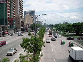
- Busiest highway: Epifanio De los Santos Avenue (C-4) (2.35 Million Vehicles per day)
- Longest expressway: Subic-Clark-Tarlac Expressway
- Highest Altitude Highway: Halsema Highway (7,400 feet (2,300 metres) above sea level)
See also
References
- 1 2 Encyclopedia Britannica (1983). Pan Philippine Highway. United States of America: Britannica.
- 1 2 mntc.com. "North Luzon Expressway". Retrieved July 2, 2012.
- ↑ DPWH Philippines. "DPWH Philippines". Retrieved April 2012. Check date values in:
|access-date=(help) - ↑ URPO. "3rd Urpo" (PDF). Retrieved April 2012. Check date values in:
|access-date=(help)