Highway 41 (Israel)
| |
|---|---|
|
כביש 41 Kvish Arba'im ve'Ehad | |
 | |
| Route information | |
| Length: | 3.9 km (2.4 mi) |
| Major junctions | |
| West end: |
|
| |
| East end: | |
| Location | |
| Major cities: | Ashdod |
| Highway system | |
| Highways | |

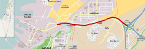
Highway 41 is an arterial road in south-central Israel. It connects Highway 4 and Highway 7 to the Port of Ashdod. The designation "41" also applied to the continuation of the road eastward to Gedera until that section of the road was upgraded and renamed "7".
Upgrade
Within Ashdod, the road has been widened and reoriented. West of the former Hashmal Junction, instead of traveling west-southwest following Nir Galim Rd. and Tel Mor Rd. to Laskov Rd., the road has been rebuilt to continue due west ending at the new entrance to the Ashdod Port. A traffic light controlled intersection now provides access to Nir Galim Rd to the southwest and a new road northward to Eshkol Power Station and new industrial and commercial zones associated with the port.[1]
East of Ashdod, the highway has undergone reconstruction upgrading it to a controlled-access highway.[2] Traffic controlled junctions at Highway 4 and Highway 42 have been replaced by multi-level interchanges. Eastward between Highway 4 and Highway 40 the road has been widened, new interchanges built at Beit Rabban and Gedera, and the junction at Kannot Youth Village was eliminated. Upon completion in August 2014, this section of Highway 41 was renumbered "7" directly connecting to the existing Highway 7.[3][4][5][6][7]
Junctions (west to east)
| km | Name | Type | Meaning | Location | Roads crossed |
|---|---|---|---|---|---|
| 0 | |
Port of Ashdod | entrance to new port terminal | ||
| 0.4 | |
Ashdod, Eshkol Power Station, Israel Ports Industrial Park |
Derech Nir Galim | ||
| 0.6 | צומת חשמל (Hashmal Junction) (eliminated) |
|
electricity | Ashdod Eshkol Power Station |
HaHashmal St |
| 1.2 | צומת נמל אשדוד (Namal Ashdod Junction) |
|
Port of Ashdod | Ashdod Industrial Zone 3, Century Park Industrial Zone |
HaMada St. Bnei Brit Blvd. |
| 2.4 | צומת ניר גלים (Nir Galim Junction) |
|
Meadow of Waves | Ashdod Industrial Zone 3, Nir Galim |
HaNeft St. HaHakla'it Blvd. |
| 3.6 | |
Bnei Darom Yeshivat Neve Herzog |
|||
| 3.9 | מחלף אשדוד (Ashdod Interchange) |
|
Ashdod | |
References
- ↑ "Highway 41 - Between Ashdod Interchange and Nir Galim". National Roads Company of Israel. Retrieved 2012-11-27.(Hebrew)
- ↑ "Level separation at Bnei Darom Junction". National Roads Company of Israel. Retrieved 2013-06-25.(Hebrew)
- ↑ "Highway 7 - Ashdod and Gadera Interchanges". National Roads Company of Israel. Retrieved 2013-06-02.(Hebrew)
- ↑ "Highway 7 - Between Ashdod Interchange and Kannot Junction". National Roads Company of Israel. Retrieved 2012-11-27.(Hebrew)
- ↑ "Highway 7 - Ashdod Gadera - Eastern Section". National Roads Company of Israel. Retrieved 2012-11-27.(Hebrew)
- ↑ "Arrangemant of Gedera Interchange and Beit Raban". National Roads Company of Israel. Retrieved 2012-10-22.(Hebrew)
- ↑ "Gedera Interchange Upgrade Project was launched". Gedera Municipality. Retrieved 2012-10-22.(Hebrew)
See also
| Roads |
| ||||||
|---|---|---|---|---|---|---|---|
| Bus operators | |||||||
| Rail transport |
| ||||||
| Sea ports | |||||||
| Aviation |
| ||||||
| Cable cars | |||||||
| By city | |||||||
| Smart cards | |||||||
Coordinates: 31°49′40″N 34°42′37″E / 31.82778°N 34.71028°E