Highland Light
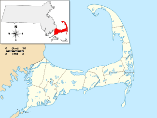
The Highland Light (previously known as Cape Cod Light) is an active lighthouse on the Cape Cod National Seashore in North Truro, Massachusetts. It is the oldest and tallest lighthouse on Cape Cod.[5] The grounds are open year-round, while the light is open to the public from May until late October, with guided tours available. It is owned by the National Park Service, and cared for by the Highland Museum and Lighthouse, Inc., while the United States Coast Guard operates the light itself.[6] The United States Navy ship USS Highland Light (IX-48) was named after the light. It is listed on the National Register of Historic Places as Highland Light Station.[4]
History
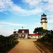
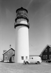
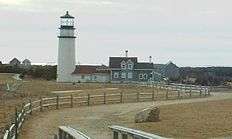
In 1797, a station authorized by George Washington was established at this point on the Cape, with a wood lighthouse to warn ships about the dangerous coastline between Cape Ann and Nantucket. It was the first light on Cape Cod. In 1833, the wood structure was replaced by brick and in 1840 a new lantern and lighting apparatus was installed. In 1857 the lighthouse was declared dangerous and demolished, and for a total cost of $17,000, the current 66 foot brick tower was constructed,[7] with a first order Fresnel lens from Paris. Along with the lighthouse, there was a keeper's building and a generator shed, both of which can still be seen today.
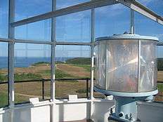
In 1932 the lamp was upgraded to a 1000-watt beacon. The Fresnel lens system was replaced first by a Crouse and Hinds DCB-36 double rotating light and then by a Carlisle & Finch DCB-224, with a second unit as backup. Unfortunately, the Fresnel lens was largely destroyed when it was removed, but fragments are on display in the museum on site. Finally, in 1998, a VRB-25 optical system was installed.[3]
The present location of the lighthouse is not the original site. It was in danger of falling down the cliff due to beach erosion, so the structure was moved 450 feet (140 m) to the west. The move was accomplished by International Chimney Corp. of Buffalo, New York and Expert House Movers of Maryland over a period of 18 days in July, 1996.[3] It is now on Cape Cod National Seashore property, bordering the Highland Golf Course. After an errant golf ball broke a window, they were replaced with unbreakable material. The lighthouse grounds are open year-round on Highland Light Road in Truro, with tours and the museum available by the National Park Service during the summer months.[7]
Gallery
| Images of the Cape Cod (Highland) Light |
|---|
| The original location of the lighthouse is indicated by the boulder in the foreground. |
| The current VRB-25 optical system |
| The lighthouse in September, 2014 |
|
See also
References
External links
 |
Wikisource has original text related to this article:
|
|
|---|
|
| Topics | | |
|---|
|
| Lists by county | |
|---|
|
| Lists by city | Barnstable County | |
|---|
| Bristol County | |
|---|
| Essex County | |
|---|
| Hampden County | |
|---|
| Middlesex County | |
|---|
| Norfolk County | |
|---|
| Suffolk County | |
|---|
| Worcester County | |
|---|
|
|---|
|
| Other lists | |
|---|
|
-
 Category Category
-
 NRHP portal NRHP portal
- Massachusetts portal
|

 Media related to Highland Light at Wikimedia Commons