High-water mark of the Confederacy
| High-Water Mark of the Confederacy | |
 To the left (east) of The Angle stone wall was the farthest advances of the units of Longstreet's assault during the 1863 Battle of Gettysburg.[1] | |
| Country | United States |
|---|---|
| State | Pennsylvania |
| County | Adams |
| NPS unit | Gettysburg National Military Park |
| Landform | Cemetery Ridge |
| Location | The Angle |
| - coordinates | 39°48.747′N 77°14.143′W / 39.812450°N 77.235717°WCoordinates: 39°48.747′N 77°14.143′W / 39.812450°N 77.235717°W |
| Establishing event |
Pickett's charge, July 3, 1863 |
The high-water mark of the Confederacy refers to an area on Cemetery Ridge near Gettysburg, Pennsylvania, marking the farthest point reached by Confederate forces during Pickett's Charge on July 3, 1863.[1] Similar to a high water mark of water, the term is a reference to arguably the Confederate Army's best chance of achieving victory in the war. The line of advance was east of "The Angle" stone wall[2] at various distances, e.g., the Virginians pushed the Union line back.
History
This designation was invented by government historian John B. Bachelder after the war when the monuments of the Gettysburg Battlefield were being erected.[3] Some historians have argued that the battle was the turning point of the war and that this was the place that represented the Confederacy's last major offensive operation in the Eastern Theater.
On the third day of the battle (July 3, 1863), Confederate General Robert E. Lee ordered an attack on the Union center, located on Cemetery Ridge. This offensive maneuver called for almost 12,500 men to march over 1,000 yards of dangerously open terrain.
Preceded by a massive but mostly ineffective Confederate artillery barrage, the march across open fields toward the Union lines became known as Pickett's Charge; Maj. Gen. George E. Pickett was one of three division commanders under the command of Lt. Gen. James Longstreet, but his name has been popularly associated with the assault. Union guns and infantry on Cemetery Ridge opened fire on the advancing men, inflicting a 50% casualty rate on the Confederate ranks. One of Pickett's brigade commanders was General Lewis Addison Armistead. His men were able to breach the Union lines in just one place, a bend in the wall that has become known as "the Angle." This gap in the Union line was quickly closed with any Confederate soldiers who had breached it being quickly captured or killed, including Armistead.
Lee's Army of Northern Virginia retreated the next day, leaving Gettysburg for Virginia. Even though the war lasted almost another two years, Lee launched few offensive operations during that time, none of them near the scale of the Gettysburg Campaign.
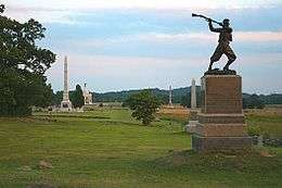
Monuments
Monuments at the high-water mark include the High Water Mark of the Rebellion Monument, the 72nd Pennsylvania Infantry Monument, and the Vermont monument with George Stannard statue.[4]

- Cushing Marker
- The Alonzo Cushing Marker indicates the "spot where Lt. Alonzo H. Cushing was mortally wounded"[5] at the "extreme point reached by the Confederates in this, their supremest effort. … Where Cushing and Armistead lie is where the tide of invasion stops. The confederate cause is buried there."
- Armistead Marker
- The 1887 Lewis A. Armistead Marker[6] marks the spot where the Confederate General placed his hand on a Union cannon before collapsing with mortal wounds.[7] Armistead was one of 1500 Confederate Virginians that broke through the Union line at The Angle.[8]
- NY 1st Artillery
- The New York 1st Independent Artillery Memorial commemorates the Cowan Battery which fired on Pickett's Charge and had a cannon temporarily captured by Armistead's troops.
References
- 1 2 Bachelder, John B (1892), High Water Mark of the Rebellion Monument (NPS.gov webpage about monument), Gettysburg Battlefield Memorial Association, retrieved 2011-02-11,
rear tablet added 1895 (MN389) listing directors of Gettysburg Battlefield Memorial Association. All 9'H.
- ↑ "The Angle stone wall: WA03" (NPS.gov webpage), List of Classified Structures, p. 44, United States Department of War, retrieved 2011-06-06,
Stone wall consists of dry-laid field granite stones and measures 4'0"H x 3'9"H x 1030'. Originally separated the Leister and Small Farm properties from Biggs Farm property.
External link in|work=(help) - ↑ Desjardin, Thomas A. These Honored Dead: How the Story of Gettysburg Shaped American Memory." ISBN 0-30681-382-3
- ↑ "Day 3: July 3, 1863 - Pickett's Charge". MilitaryHistoryOnline.com. Retrieved 2011-05-07.
- ↑ "Alonzo Cushing Marker: MN394" (NPS.gov webpage), List of Classified Structures, p. 25, 1887, retrieved 2011-06-15,
1 of 16 Civil War Monuments of the GBMA Era (1863 - 1895) commemorating killed or wounded officers. Indicates spot where Lt. Alonzo H. Cushing was mortally wounded July 3, 1863. Located in the Angle near the Battery marker.
External link in|work=(help) - ↑ "Lewis A. Armistead Marker: MN754" (NPS.gov webpage), List of Classified Structures, p. 39, 1887, retrieved 2011-06-14,
First marker erected to commemorate fallen Confederate commander. Denotes site where Brig. Gen. Lewis A. Armistead was mortally wounded. Located in the Angle area, W of Cushing's Battery. … Mn base 2'x2' smooth cut. Shaft designed to simulate opening scroll w/incised inscription in face. Badly eroded. All 4'6"H. … Marker is a granite shaft designed to simulate an opening scroll with an incised inscription on the face and set on a two foot square smooth cut base. Overall height is 4.6 feet. Located at the Angle.
External link in|work=(help) - ↑ "It's Again A Tented Field: Sickles And Longstreet At Gettysburg". New York Times. July 1, 1888. Retrieved 2011-06-15.
The stone marked the spot where Armistead put his hand on a Union cannon and said, "Gentlemen, this gun is ours." In another moment he was"
[wounded] - ↑ "A Gettysburg Reunion" (Google News Archive). The Canaseraga Times. July 8, 1887. Retrieved 2011-02-11.
One of the dramatic incidents of the day took place at the bloody angle where 1,500 Virginians broke through the lines held by their hosts, and where the three monuments were dedicated on the 3d
(of July 1887).