High Schells Wilderness
| High Schells Wilderness | |
|---|---|
|
IUCN category Ib (wilderness area) | |
 | |
 | |
| Location | White Pine County, Nevada United States |
| Nearest city | Ely, Nevada |
| Coordinates | 39°20′24″N 114°35′57″W / 39.3399041581°N 114.599215912°W[1]Coordinates: 39°20′24″N 114°35′57″W / 39.3399041581°N 114.599215912°W[2] |
| Area | 121,497 acres (49,168 ha) |
| Established | December 20, 2006 |
| Governing body | U.S. Forest Service |
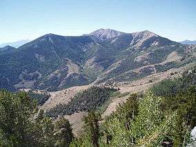
The High Schells Wilderness is a 121,497-acre (49,168 ha) wilderness area in the Schell Creek Range of White Pine County, in the U.S. state of Nevada. The Wilderness lies within the Humboldt-Toiyabe National Forest and is therefore administered by the U.S. Forest Service.[3]
Flora and fauna
The High Schells Wilderness is home to an abundance of elk, mule deer, and mountain lion, which thrive in forests of quaking aspen, Douglas and white fir, Engelmann spruce, and limber and bristlecone pine. Golden eagles can be seen soaring the updrafts along the crest of the Schell Creek Range. Riparian vegetation provides key habitat for blue grouse, sage grouse, chukar and many other species. Perennial streams throughout the area support populations of rainbow, brook, cutthroat and brown trout.[4]
Archeology
Archeological sites in the High Schells Wilderness include petroglyphs and lithic scatters.[4]
See also
- Nevada Wilderness Areas
- List of wilderness areas in Nevada
- List of U.S. Wilderness Areas
- Wilderness Act
References
- ↑ "High Schells Wilderness Map". Wilderness.net. Retrieved 2011-08-19.
- ↑ "High Schells Wilderness Map". Wilderness.net. Retrieved 2011-08-19.
- ↑ Humboldt-Toiyabe National Forest - High Schells Wilderness
- 1 2 Friends of Nevada Wilderness - High Schells Wilderness
External links
- Humboldt-Toiyabe National Forest - High Schells Wilderness
- Friends of Nevada Wilderness - High Schells Wilderness
- official Humboldt-Toiyabe National Forest website
- National Atlas: Map of Humboldt-Toiyabe National Forest
- NevadaWilderness.org