Hickman, Kentucky
| Hickman, Kentucky | |
|---|---|
| City | |
|
Fulton County Courthouse in Hickman | |
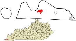 Location within Fulton County and the state of Kentucky | |
| Coordinates: 36°34′2″N 89°11′11″W / 36.56722°N 89.18639°WCoordinates: 36°34′2″N 89°11′11″W / 36.56722°N 89.18639°W | |
| Country | United States |
| State | Kentucky |
| County | Fulton |
| Named for | a local landowner's wife |
| Area | |
| • Total | 3.6 sq mi (9.3 km2) |
| • Land | 3.6 sq mi (9.2 km2) |
| • Water | 0.0 sq mi (0.0 km2) |
| Elevation | 469 ft (143 m) |
| Population (2010) | |
| • Total | 2,395 |
| • Density | 665.3/sq mi (260.3/km2) |
| Time zone | Central (CST) (UTC-6) |
| • Summer (DST) | CDT (UTC-5) |
| ZIP code | 42050 |
| Area code(s) | 270 & 364 |
| FIPS code | 21-36298 |
| GNIS feature ID | 0494109 |

Hickman is a city in and the county seat of Fulton County, Kentucky, United States.[1] Located on the Mississippi River, the city had a population of 2,395 at the 2010 U.S. census and is classified as a home rule-class city[2] Hickman is part of the Union City micropolitan area.
History
European-American settlement of this area did not begin until decades after the American Revolutionary War. James Mills built the first cabin on the site in 1819. The community of Mills Point was large enough to receive a post office in 1830. Around 1834, G. Marr purchased much of the surrounding area and laid out more streets.[3]
The community was renamed Hickman in 1837 after the maiden name of Marr's wife. The city was formally incorporated by the state assembly on February 18, 1841.[4] In 1845, it became the county seat.[3]
Two floods devastated Hickman, the first in 1912 and the second in 1913.[5] The flood of 1912 began when a levee located near Hickman broke. Within a few hours the water had risen to the roofs of houses. The flood of 1913 began when a levee near West Hickman broke on April 4. Baseball pitcher Rube Waddell was among the many who helped save the city during both floods. Waddell came down with pneumonia after each flood and subsequently died of tuberculosis.
Geography
According to the United States Census Bureau, the city has a total area of 3.6 square miles (9.3 km2), of which 3.6 square miles (9.3 km2) is land and 0.28% is water.
Climate
The climate in this area is characterized by hot, humid summers and generally mild to cool winters. According to the Köppen Climate Classification system, Hickman has a humid subtropical climate, abbreviated "Cfa" on climate maps.[6]
Demographics
| Historical population | |||
|---|---|---|---|
| Census | Pop. | %± | |
| 1850 | 401 | — | |
| 1860 | 1,006 | 150.9% | |
| 1870 | 1,120 | 11.3% | |
| 1880 | 1,264 | 12.9% | |
| 1890 | 1,652 | 30.7% | |
| 1900 | 1,589 | −3.8% | |
| 1910 | 2,736 | 72.2% | |
| 1920 | 2,033 | −25.7% | |
| 1930 | 2,321 | 14.2% | |
| 1940 | 2,268 | −2.3% | |
| 1950 | 2,037 | −10.2% | |
| 1960 | 1,537 | −24.5% | |
| 1970 | 3,048 | 98.3% | |
| 1980 | 2,894 | −5.1% | |
| 1990 | 2,689 | −7.1% | |
| 2000 | 2,560 | −4.8% | |
| 2010 | 2,395 | −6.4% | |
| Est. 2015 | 2,202 | [7] | −8.1% |
As of the census[9] of 2000, there were 2,560 people, 1,015 households, and 665 families residing in the city. The population density was 718.1 people per square mile (277.6/km²). There were 1,177 housing units at an average density of 330.2 per square mile (127.7/km²). The racial makeup of the city was 64.06% White, 34.96% African American, 0.08% Native American, 0.04% from other races, and 0.86% from two or more races. Hispanic or Latino of any race were 0.51% of the population.
There were 1,015 households out of which 28.2% had children under the age of 18 living with them, 39.8% were married couples living together, 22.4% had a female householder with no husband present, and 34.4% were non-families. 32.1% of all households were made up of individuals and 14.8% had someone living alone who was 65 years of age or older. The average household size was 2.33 and the average family size was 2.94.
In the city the population was spread out with 24.9% under the age of 18, 10.9% from 18 to 24, 26.8% from 25 to 44, 23.0% from 45 to 64, and 14.4% who were 65 years of age or older. The median age was 36 years. For every 100 females there were 94.2 males. For every 100 females age 18 and over, there were 90.2 males.
The median income for a household in the city was $21,655, and the median income for a family was $27,384. Males had a median income of $25,625 versus $18,264 for females. The per capita income for the city was $11,573. About 24.8% of families and 27.1% of the population were below the poverty line, including 35.0% of those under age 18 and 18.7% of those age 65 or over.
Notable historic buildings
Thomas Chapel C.M.E. Church is an historic African-American church on Moscow Avenue in Hickman, part of the Colored Methodist Episcopal Church formed by freedmen after the American Civil War. They set up their own denomination in order to be independent of white supervision in the Methodist Church, South, which had split away from northern congregations at the outbreak of war. (In 1954 they changed their name to Christian Methodist Episcopal Church.) This church was built in 1895 and added to the National Register of Historic Places in 1979.[10]
References
- ↑ "Find a County". National Association of Counties. Retrieved 2011-06-07.
- ↑ "Summary and Reference Guide to House Bill 331 City Classification Reform" (PDF). Kentucky League of Cities. Retrieved December 30, 2014.
- 1 2 Rennick, Robert M. (1987). Kentucky Place Names. University Press of Kentucky. pp. 138–139. Retrieved 28 Apr 2013.
- ↑ Commonwealth of Kentucky. Office of the Secretary of State. Land Office. "Hickman, Kentucky". Accessed 29 Jul 2013.
- ↑ "Mid-South Views on Floods of 1912 and 1913".
- ↑ Climate Summary for Hickman, Kentucky
- ↑ "Annual Estimates of the Resident Population for Incorporated Places: April 1, 2010 to July 1, 2015". Retrieved July 2, 2016.
- ↑ "Census of Population and Housing". Census.gov. Retrieved June 4, 2015.
- ↑ "American FactFinder". United States Census Bureau. Retrieved 2008-01-31.
- ↑ "National Register of Historic Places".
External links
| Wikimedia Commons has media related to Hickman, Kentucky. |
Municipalities and communities of Fulton County, Kentucky, United States | ||
|---|---|---|
| Cities |  | |
| CDP | ||
| Other unincorporated communities | ||