Hermantown, Minnesota
| Hermantown, Minnesota | |
|---|---|
| City | |
| Motto: The City of Quality Living | |
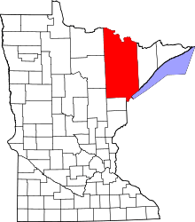
 Location of the city of Hermantown within Saint Louis County, Minnesota | |
| Coordinates: 46°48′5″N 92°13′21″W / 46.80139°N 92.22250°W | |
| Country | United States |
| State | Minnesota |
| County | Saint Louis |
| Incorporated | December 31, 1975 |
| Government | |
| • Mayor | Wayne Boucher |
| Area[1] | |
| • Total | 34.37 sq mi (89.02 km2) |
| • Land | 34.35 sq mi (88.97 km2) |
| • Water | 0.02 sq mi (0.05 km2) |
| Elevation | 1,362 ft (415 m) |
| Population (2010)[2] | |
| • Total | 9,414 |
| • Estimate (2013[3]) | 9,605 |
| • Density | 274.1/sq mi (105.8/km2) |
| Time zone | Central (CST) (UTC-6) |
| • Summer (DST) | CDT (UTC-5) |
| ZIP codes | 55811, 55810 |
| Area code(s) | 218 |
| FIPS code | 27-28682 |
| GNIS feature ID | 0660490[4] |
| Website | www.hermantownmn.com |
Hermantown is a city in Saint Louis County, Minnesota, United States. The population was 9,414 at the 2010 census.[5] A suburb of Duluth, Minnesota, it has been the only city in the county to report population growth as much of the area's residential and commercial expansion occurs there. Hermantown is located near the tip of Lake Superior.
The eastern part of Hermantown has an appearance typical of a lower-density bedroom community, with large, leafy lots and occasional subdivisions. The car-oriented "Miller Hill area", or Miller Trunk Corridor of Duluth, has sprawled well past the city boundary line into this part of Hermantown. The western part of Hermantown is dominated by a more rural landscape, reminiscent of the past agricultural focus of the city. Hermantown's motto is "The City of Quality Living ".
Hermantown's current mayor is Wayne Boucher, who won a 2008 election against opponent Susie Stockinger. Mayor Boucher ran unopposed for a second mayoral term in 2012 and received 4,111 votes. There were 79 write-ins for mayor during the 2012 election.
History
The first inhabitants of the area were Native Americans. They lived in the area often referred to in early Duluth references as "the land up over the hill."
In 1867, August Kohlts and his friend, Pat Acker, filed for homesteads in Section 18, Township 50 North, Range 15 West. Both families had immigrated earlier in the 1860s from Prussia to New York, with August Kohlts and his wife, Emilie, coming to America in the spring of 1860. Probably they went via the Erie Canal to Grand Island, New York, situated in Erie County on the Niagara River. The Kohlts and the Ackers resided at Grand Island in the town of Tonawanda for some years with many other Germans who settled in the area. Citizenship was granted to August Kohlts on March 20 1868, and soon afterward his family set out from Buffalo New York, heading west via the Great Lakes, for the Hancock Michigan area of the Keewenaw Peninsula, with its copper mines. There the growing August Kohlts family settled for a year while August probably toiled in the copper mines. However, perhaps lured by the availability of free land under the Homestead Act, August, Emilie and their children left for Minnesota. The Federal census of June 1, 1870, records their presence in the Second Ward of the newly formed city of Duluth, Minnesota. By January 1872 August Kohlts had established an eighty-two acre site in the wilderness outside Duluth, with he and the Pat Acker family being the first settlers in the area now known as Hermantown.
In the years that followed, August, along with Pat Acker, alternated between working in the young town of Duluth and clearing land at their rural homesteads. They traveled the distance between Duluth and their homesteads on a Native American trail that would later become Piedmont Avenue and the Hermantown Road Hermantown's population would get a boost from a new wave of homesteaders just before World War II.
During the hard times of the Great Depression, the federal government built nearly a hundred "subsistence homestead" projects designed to move people trapped in poverty in the cities, to new homes in rural or suburban locations. One of the two Minnesota projects was assigned to Hermantown.
The Jackson Project was completed in 1937. It is one of Hermantown's more interesting features, and is the proliferation of "Jackson Homes" on certain roadways. These single-family dwellings were built during the Great Depression as subsistence homesteads. Many today retain their original brick appearance, albeit with additions. Each of the 84 homesteads had a brick veneer farmhouse; half also had a garage-barn combination. Each had five or 10 acres (40,000 m2) of land, and the family also received a pig, a cow, and 35 chickens. The idea was that the family would be able to raise its own food and use the profits from selling any surplus to work off its debt to the government. The units were sold to homesteaders on very liberal terms: the average price for the home and property was $2,687.40 plus interest.
The Jackson Project was one of the later projects built, which was a benefit because the quality of housing improved. Plumbing and electricity were now required in all homes. The homesteaders gave a whole new profile to what was then Herman Township. Now with 84 homes and families concentrated in one part of the community, the Project marked the start of a transition from rural to suburban for Hermantown.
Hermantown was incorporated as a city on December 31, 1975.
The community of Adolph is located within the southwest corner of the city of Hermantown.
Geography
According to the United States Census Bureau, the city has a total area of 34.37 square miles (89.02 km2); 34.35 square miles (88.97 km2) is land and 0.02 square miles (0.05 km2) is water.[1]
U.S. Highway 53, State Highway 194 (MN 194), and County Road 13 (Midway Road) are three of the main routes in Hermantown. Other routes include Maple Grove Road, Haines Road, Arrowhead Road, Stebner Road, Morris Thomas Road, Ugstad Road, and Lavaque Road.
Major highways
Miller Creek flows through the northeast corner of Hermantown. Keene Creek flows through the southeast and east portions of the city. Kingsbury Creek briefly enters the south-central part of the city near Ugstad Road. Merritt Creek briefly enters the southeast corner of Hermantown. Rocky Run flows through the northwest and west-central parts of the city.
The Midway River rises in Hermantown and flows generally southwest through the central and southwest portions of the city before entering adjacent Midway Township. The Midway River flows into the Saint Louis River in Thomson Township near Cloquet.
Seville Road runs east–west along Hermantown's northern boundary line with adjacent Canosia Township in the northwest and north–central parts of Hermantown. Solway Road runs north–south along Hermantown's western boundary line with adjacent Solway Township. Saint Louis River Road runs east–west along Hermantown's southern boundary line with adjacent Midway Township in the southwest part of Hermantown. Haines Road runs north–south along Hermantown's eastern boundary line with adjacent city of Duluth.
The Duluth International Airport is to the immediate northeast of Hermantown. The Pike Lake Business District of Canosia Township is to the immediate northwest of the city. The city of Proctor is located immediately south of Hermantown at the south-central part of Hermantown. The Bayview Heights neighborhood of Duluth is to the immediate southeast of the city. The Piedmont Heights and Duluth Heights neighborhoods of Duluth are both to the immediate east of Hermantown.
Demographics
| Historical population | |||
|---|---|---|---|
| Census | Pop. | %± | |
| 1980 | 6,759 | — | |
| 1990 | 6,761 | 0.0% | |
| 2000 | 7,448 | 10.2% | |
| 2010 | 9,414 | 26.4% | |
| Est. 2015 | 9,706 | [6] | 3.1% |
| U.S. Decennial Census[7] 2013 Estimate[3] | |||
2010 census
As of the census[2] of 2010, there were 9,414 people, 3,355 households, and 2,351 families residing in the city. The population density was 274.1 inhabitants per square mile (105.8/km2). There were 3,544 housing units at an average density of 103.2 per square mile (39.8/km2). The racial makeup of the city was 93.1% White, 2.4% African American, 1.2% Native American, 1.2% Asian, 0.5% from other races, and 1.6% from two or more races. Hispanic or Latino of any race were 2.2% of the population.
There were 3,355 households of which 33.1% had children under the age of 18 living with them, 58.4% were married couples living together, 7.5% had a female householder with no husband present, 4.2% had a male householder with no wife present, and 29.9% were non-families. 23.5% of all households were made up of individuals and 12.5% had someone living alone who was 65 years of age or older. The average household size was 2.55 and the average family size was 3.01.
The median age in the city was 40.1 years. 22.6% of residents were under the age of 18; 8.2% were between the ages of 18 and 24; 26.5% were from 25 to 44; 28.9% were from 45 to 64; and 13.9% were 65 years of age or older. The gender makeup of the city was 54.0% male and 46.0% female.
2000 census
As of the 2000 census, there were 7,448 people, 2,726 households, and 2,077 families residing in the city. The population density was 216.9 people per square mile (83.8/km²). There were 2,822 housing units at an average density of 82.2 per square mile (31.7/km²). The racial makeup of the city was 97.27% White, 0.36% African American, 0.83% Native American, 0.47% Asian, 0.05% Pacific Islander, 0.11% from other races, and 0.90% from two or more races. Hispanic or Latino of any race were 0.63% of the population. 19.5% were of Norwegian, 15.9% German, 13.2% Swedish, 9.0% Finnish and 6.5% Irish ancestry.
There were 2,726 households out of which 37.9% had children under the age of 18 living with them, 64.9% were married couples living together, 8.3% had a female householder with no husband present, and 23.8% were non-families. 19.8% of all households were made up of individuals and 8.6% had someone living alone who was 65 years of age or older. The average household size was 2.67 and the average family size was 3.08.
In the city the population was spread out with 27.1% under the age of 18, 7.1% from 18 to 24, 28.4% from 25 to 44, 23.8% from 45 to 64, and 13.6% who were 65 years of age or older. The median age was 38 years. For every 100 females there were 98.0 males. For every 100 females age 18 and over, there were 92.8 males.
The median income for a household in the city was $49,861, and the median income for a family was $55,632. Males had a median income of $41,152 versus $25,481 for females. The per capita income for the city was $20,993. About 2.2% of families and 4.1% of the population were below the poverty line, including 4.7% of those under age 18 and 5.0% of those age 65 or over.
References
- 1 2 "US Gazetteer files 2010". United States Census Bureau. Retrieved 2012-11-13.
- 1 2 "American FactFinder". United States Census Bureau. Retrieved 2012-11-13.
- 1 2 "Population Estimates". United States Census Bureau. Retrieved 2014-07-14.
- ↑ "US Board on Geographic Names". United States Geological Survey. 2007-10-25. Retrieved 2008-01-31.
- ↑ "2010 Census Redistricting Data (Public Law 94-171) Summary File". American FactFinder. U.S. Census Bureau, 2010 Census. Retrieved 23 April 2011.
- ↑ "Annual Estimates of the Resident Population for Incorporated Places: April 1, 2010 to July 1, 2015". Retrieved July 2, 2016.
- ↑ United States Census Bureau. "Census of Population and Housing". Retrieved September 12, 2013.
External links
| Wikivoyage has a travel guide for Hermantown. |
- City of Hermantown, MN – Official Website
- Hermantown Schools site
- Hermantown Area Chamber of Commerce site
- Hermantown Star newspaper site
Coordinates: 46°48′25″N 92°14′18″W / 46.80694°N 92.23833°W
| Core cities |   | ||||||
|---|---|---|---|---|---|---|---|
| Surrounding communities |
| ||||||
| Counties |
| ||||||