Henty Highway
| Henty Highway Victoria | |
|---|---|
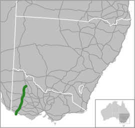 | |
| Map of south-eastern Australia with Henty Highway highlighted in green | |
| General information | |
| Type | Highway |
| Length | 360 km (224 mi) |
| Route number(s) | |
| Former route number |
|
| Major junctions | |
| North end |
|
| |
| South end |
|
| Location(s) | |
| Major settlements | Hopetoun, Warracknabeal, Horsham, Hamilton, Heywood |
| Highway system | |
|
Highways in Australia National Highway • Freeways in Australia Highways in Victoria | |
| |
Henty Highway[2] is a 360 kilometre highway in western Victoria, Australia. It's primarily a north-south route, and consists of a mix of 2 laned country highway standard and 4 lane arterial road within some of the larger towns along the route. The highway formerly ran all the way to meet the Calder Highway at its junction south of Ouyen, but when the Sunraysia Highway was given highway status, the Henty name was truncated back to Lascelles.
Henty Highway shares other roads along its route (this is called multiplexing), and these include:
- A1 (Princes Highway) from Heywood to Portland North for 27 km
- A8 (Western Highway) at Horsham for 3 km
- B160 (Glenelg Highway) at Hamilton for 3 km
- B240 (Wimmera Highway) from Horsham to Dooen for 10 km
- C188 (Natimuk-Hamilton Road and Penshurst-Dunkeld Road) at Cavendish for 500 m
- C234 (Borung Highway) at Warracknabeal for 1 km
Major intersections and towns
| Henty Highway | |||
| Northbound | Distance to Mildura (km) |
Distance to Portland (km) |
Southbound |
| End Henty Highway continues as Sunraysia Highway to Ouyen and Mildura |
169 | 354 | Start Henty Highway from Sunraysia Highway |
| Birchip Sunraysia Highway | |||
| Sea Lake, Swan Hill Hopetoun-Sea Lake Road |
186 | 337 | Sea Lake Hopetoun-Sea Lake Road |
| Patchewollock, Walpeup Hopetoun-Wallpeup Road |
190 | 333 | Patchewollock, Walpeup Hopetoun-Wallpeup Road |
| Rainbow Hopetoun-Rainbow Road |
193 | 330 | Hopetoun |
| Hopetoun | Rainbow Hopetoun-Rainbow Road | ||
| Rainbow, Birchip Birchip-Rainbow Road |
218 | 305 | Birchip, Rainbow Birchip-Rainbow Road |
| continues as |
254 | 269 | Rainbow Warracknabeal-Rainbow Road Donald, Charlton Borung Highway |
| Donald, Charlton Borung Highway Rainbow Warracknabeal-Rainbow Road |
| ||
| |
255 | 268 | Warracknabeal |
| Dimboola, Adelaide Borung Highway |
Dimboola, Adelaide Borung Highway | ||
| Stawell Stawell-Warracknabeal Road |
Stawell, Melbourne Stawell-Warracknabeal Road | ||
| Warracknabeal | continues as | ||
| Minyip, Donald Horsham-Minyip Road |
284 | 239 | Minyip, Donald Horsham-Minyip Road |
| continues as |
301 | 222 | Murtoa, St Arnaud Wimmera Highway |
| Murtoa, St Arnaud, Bendigo Wimmera Highway |
| ||
| Start continues with |
311 | 212 | Horsham |
| Dimboola, Adelaide Western Highway |
End | ||
| End |
Dimboola, Adelaide Western Highway | ||
| Horsham | Start continues with | ||
| |
312 | 211 | Edenhope, Naracoorte Wimmera Highway |
| Edenhope, Naracoorte Wimmera Highway |
continues as | ||
| Horsham-Drung South Road |
313 | 210 | Horsham-Drung South Road |
| |
314 | 209 | Ararat, Ballarat, Melbourne Western Highway |
| Ararat, Ballarat, Melbourne Western Highway |
continues as | ||
| continues as |
415 | 108 | Balmoral Natimuk-Hamilton Road |
| Balmoral Natimuk-Hamilton Road |
| ||
| |
415.5 | 107.5 | Cavendish |
| Dunkeld Dunkeld-Cavendish Road |
Dunkeld Dunkeld-Cavendish Road | ||
| Cavendish | continues as | ||
| continues as |
438 | 85 | Casterton, Mount Gambier Glenelg Highway |
| Casterton, Mount Gambier Glenelg Highway |
| ||
| |
440.5 | 82.5 | Hamilton |
| Town Centre, Ballarat Glenelg Highway | |||
| Town Centre, Ballarat Glenelg Highway |
continues as | ||
| continues as |
441.4 | 81.6 | Dartmoor Dartmoor-Hamilton Road |
| Dartmoor Dartmoor-Hamilton Road |
| ||
| |
441.5 | 81.5 | Town Centre Dartmoor-Hamilton Road |
| Town Centre To Dartmoor-Hamilton Road |
continues as | ||
| Hamilton | |||
| Port Fairy Hamilton-Port Fairy Road |
442.5 | 80.5 | Port Fairy Hamilton-Port Fairy Road |
| Macarthur Myamin-Macarthur Road |
483 | 40 | Macarthur Myamin-Macarthur Road |
| continues as |
499 | 24 | Mount Gambier, Adelaide Princes Highway |
| Mount Gambier, Adelaide Princes Highway |
| ||
| Woolsthorpe, Warrnambool via Town Bypass Woolsthorpe-Heywood Road |
499.5 | 23.5 | Woolsthorpe, Warrnambool via Town Bypass Woolsthorpe-Heywood Road |
| Heywood | 500 | 23 | Heywood |
| |
520 | 3 | To Warrmambool, Geelong, Melbourne Princes Highway |
| To Warrmambool, Geelong, Melbourne Princes Highway |
continues as | ||
| Town Centre New Street |
523 | 0 | Portland |
| Town Centre New Street | |||
| Nelson Portland-Nelson Road |
524.3 | -- | Nelson Portland-Nelson Road |
| Cape Bridgewater Bridgewater Road via Link Road |
525.5 | -- | Cape Bridgewater Bridgewater Road via Link Road |
| Madeira Packet Road |
526.5 | -- | Madeira Packet Road |
| Start Henty Highway from Madeira Packet Road |
529 | -- | End Henty Highway continues as Madeira Packet Road |
See also
References
- ↑ State Route Numbering System - The former route numbering in rural Victoria, Main Roads Victoria. Retrieved on 14 September 2013.
- ↑ Henty Highway (A/B200), Expressway - Paul Rands. Retrieved on 14 September 2013.
This article is issued from Wikipedia - version of the 7/15/2016. The text is available under the Creative Commons Attribution/Share Alike but additional terms may apply for the media files.