Henfield
| Henfield | |
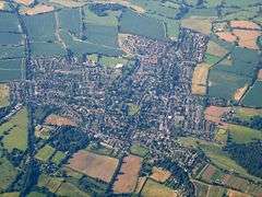 Henfield from the air |
|
 Henfield |
|
| Area | 17.35 km2 (6.70 sq mi) [1] |
|---|---|
| Population | 5,012 [1] 2001 Census 5,349 (2011 Census)[2] |
| – density | 289/km2 (750/sq mi) |
| OS grid reference | TQ215162 |
| – London | 40 miles (64 km) N |
| Civil parish | Henfield |
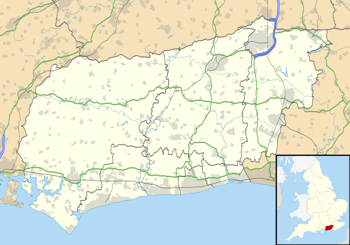
| District | Horsham |
| Shire county | West Sussex |
| Region | South East |
| Country | England |
| Sovereign state | United Kingdom |
| Post town | HENFIELD |
| Postcode district | BN5 |
| Dialling code | 01273 |
| Police | Sussex |
| Fire | West Sussex |
| Ambulance | South East Coast |
| EU Parliament | South East England |
| UK Parliament | Arundel and South Downs |
| Website | Official Henfield Website Parish Council |
|
|
Coordinates: 50°55′59″N 0°16′37″W / 50.933°N 0.277°W
Henfield is a large village and civil parish in the Horsham District of West Sussex, England. It lies 33 miles (53 km) south of London, 12 miles (19 km) northwest of Brighton, and 30 miles (48 km) east northeast of the county town of Chichester at the road junction of the A281 and A2037. The parish has a land area of 4,285 acres (1,734.1 ha). In the 2001 census 5,012 people lived in 2,153 households, of whom 2,361 were economically active. Other nearby towns include Burgess Hill to the east and Shoreham-by-Sea to the south. The population at the 2011 Census was 5,349.[2]
Just west of the town, the two branches of the River Adur, the western Adur and the eastern Adur, meet at Betley Bridge. From Henfield the Adur flows on into the English Channel at Shoreham-by-Sea.[3]
Facilities
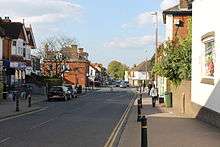
One of the largest village communities in the Horsham district, Henfield has an old and attractive centre.
It has a modern and intensely used village hall just off the High Street, the 13th-century St Peter's church, old inns, a wide and attractive common, and many interesting houses in private ownership.
There is a fire station, part of the West Sussex Fire Brigade, equipped with a single fire engine.
Henfield has one of the oldest cricket clubs in the world, dating back to 1771.
Henfield also officially has the oldest Scout group in the country (1st Henfield), dating from 1907.
To the south is Woods Mill, a restored mill, now the headquarters of the Sussex Wildlife Trust, its attractions including an extensive nature trail.
Sports facilities
Henfield Leisure Centre at Northcroft has a sports hall and fitness suite. There is a skate park located next to the sports centre where users like to build their own dirt jumps.
The Cat House
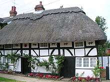
The Cat House is at Pinchnose Green, so called because there used to be a tannery nearby and the process of tanning produces unpleasant odours. This house was once owned by George Ward who had a canary. This bird was killed by a cat belonging to the Anglican Canon Nathaniel Woodard who lived at nearby Martyn Lodge. So incensed was Ward that he painted his house with pictures of a cat holding a bird that would be seen by the canon every time he walked past on his way to the church. He also rigged up strings of sea shells to rattle, and a black figure would appear at a small window called the zulu hole when the hapless canon was seen approaching.
History
Henfield was the home of Colonel Henry Bishop, who was appointed Postmaster General by King Charles II in January 1660–61. Bishop devised the first type of postmark used in England, which is known to collectors as a Bishop mark. His invention was commemorated in 1963, on the occasion of an exhibition by Henfield Stamp Club. A special date stamp, which included the wording HENRY BISHOP'S VILLAGE, was used. Bishop is buried in Henfield churchyard.
When the British government introduced the Cat and Mouse Act in 1913, local Suffragettes Elizabeth Robins used her 15th century farmhouse at Backsettown, near Henfield, that she shared with Octavia Wilberforce, as a retreat for suffragettes recovering from hunger strike.[4]
References
- 1 2 "2001 Census: West Sussex – Population by Parish" (PDF). West Sussex County Council. Retrieved 12 April 2009.
- 1 2 "Civil Parish population 2011". Neighbourhood Statistics. Office for National Statistics. Retrieved 30 September 2016.
- ↑ http://www.waterscape.com/canals-and-rivers/river-adur
- ↑ http://www.spartacus.schoolnet.co.uk/Wrobins.htm
External links
![]() Media related to Henfield at Wikimedia Commons
Media related to Henfield at Wikimedia Commons