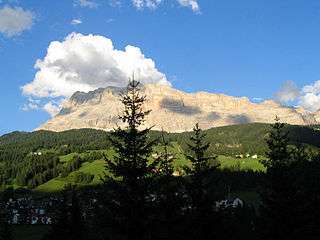
Sas dla Crusc
| Sas dla Crusc | |
|---|---|
 | |
| Highest point | |
| Elevation | 2,907 m (9,537 ft) |
| Prominence | 70 metres (230 ft) |
| Coordinates | 46°36′51.6″N 11°57′4.5″E / 46.614333°N 11.951250°ECoordinates: 46°36′51.6″N 11°57′4.5″E / 46.614333°N 11.951250°E |
| Geography | |
| Location | South Tyrol, Italy |
| Parent range | Fanes group |
The Sas dla Crusc (German: Heiligkreuzkofel, Italian: Sasso di Santa Croce [ˈsasso di ˈsanta ˈkroːtʃe]) is a mountain of the Fanes group in South Tyrol, Italy.
References
- Alpenverein South Tyrol (German)
External links
![]() Media related to Heiligkreuzkofel at Wikimedia Commons
Media related to Heiligkreuzkofel at Wikimedia Commons
This article is issued from Wikipedia - version of the 11/6/2015. The text is available under the Creative Commons Attribution/Share Alike but additional terms may apply for the media files.