Heho Airport
| Heho Airport ဟဲဟိုးလေဆိပ် | |||||||||||
|---|---|---|---|---|---|---|---|---|---|---|---|
 | |||||||||||
| IATA: HEH – ICAO: VYHH | |||||||||||
| Summary | |||||||||||
| Airport type | Public | ||||||||||
| Operator | Government | ||||||||||
| Serves | Heho, Myanmar | ||||||||||
| Elevation AMSL | 3,858 ft / 1,176 m | ||||||||||
| Coordinates | 20°44′49″N 096°47′31″E / 20.74694°N 96.79194°E | ||||||||||
| Map | |||||||||||
 HEH Location of airport in Myanmar | |||||||||||
| Runways | |||||||||||
| |||||||||||
Heho Airport (Burmese: ဟဲဟိုးလေဆိပ်; (IATA: HEH, ICAO: VYHH)) is an airport serving Heho,[1] a town in Kalaw Township, Taunggyi District, Shan State, Myanmar. It is the main airport serving Inle Lake and Taunggyi the former of the top tourist destinations of Myanmar.
History
The airport served as an airbase both for the Allies and the Japanese during World War II. The airbase was heavily bombed by the Allies. Evidence of aircraft bunker revetments and bomb craters can still be seen on the southern end of the airfield, especially noticeable from the air.
Facilities
The airport resides at an elevation of 3,858 feet (1,176 m) above mean sea level. It has one runway designated 18/36 with an asphalt surface measuring 8,500 by 100 feet (2,591 m × 30 m).[1] The original airport had a runway length of 5500 feet. It was recently expanded to accommodate jet aircraft.
Airlines and destinations
| Airlines | Destinations | Route |
|---|---|---|
| Air Bagan | Mandalay, Thandwe, Yangon | Domestic |
| Air KBZ | Mandalay, Yangon | Domestic |
| Asian Wings Airways | Mandalay, Yangon | Domestic |
| Mann Yatanarpon Airlines | Mandalay, Yangon, Bagan, Thandwe, Kengtung, Tachilek, Myitkyina | Domestic |
| Myanmar National Airlines | Kengtung, Lashio, Mong Hsat, Nyaung U, Tachilek, Yangon | Domestic |
| Yangon Airways | Mandalay, Yangon | Domestic |
 Old Building of Heho Airport
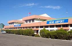
 Main Entrance of Heho Airport
 Aerial view of Heho Airport
Accidents and incidents
- On 25 December 2012, Air Bagan Flight 11, crashed short of the runway at Heho Airport. One passenger on board the aircraft plus one person on the ground were killed in the accident.[3]
- On 21 June 1987, a Myanmar Airways Fokker F-27 Friendship 200 crashed into a mountain soon after take-off from Heho Airport, killing all 45 people on board.[4]
References
- 1 2 3 Airport information for VYHH from DAFIF (effective October 2006)
- ↑ Airport information for HEH at Great Circle Mapper. Source: DAFIF (effective October 2006).
- ↑ https://aviation-safety.net/database/record.php?id=20121225-0
- ↑ https://aviation-safety.net/database/record.php?id=19870621-1
External links
| Wikimedia Commons has media related to HeHo Airport. |