Heemstede, Utrecht
| Heemstede | |
|---|---|
| Coordinates: 52°2′16″N 5°7′27″E / 52.03778°N 5.12417°ECoordinates: 52°2′16″N 5°7′27″E / 52.03778°N 5.12417°E | |
| Country | Netherlands |
| Province | Utrecht |
| Municipality | Houten |
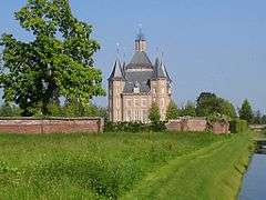
Heemstede Castle
Heemstede (52°03′N 5°07′E / 52.050°N 5.117°E) is a hamlet in the central Netherlands. It is located 3 km west of Houten, Utrecht. The hamlet is known for Heemstede Castle (1645).

Houten in 1868, with Heemstede in yellow.
Until 1812, Heemstede was a separate heerlijkheid.[1] Between 1818 and 1857 it was a part of Oud-Wulven, until that municipality merged with Houten. The area had 75 inhabitants around 1850.[1]
References
- 1 2 Abraham Jacob van der Aa, "Aardrijkskundig woordenboek der Nederlanden", vol. 5 (H), 1844.
This article is issued from Wikipedia - version of the 2/19/2016. The text is available under the Creative Commons Attribution/Share Alike but additional terms may apply for the media files.