Hayward, Wisconsin
| Hayward | |
|---|---|
| City | |
 Hayward Location of the city of Hayward | |
| Coordinates: 46°0′36″N 91°28′50″W / 46.01000°N 91.48056°WCoordinates: 46°0′36″N 91°28′50″W / 46.01000°N 91.48056°W | |
| Country | United States |
| State | Wisconsin |
| County | Sawyer |
| Government | |
| • Mayor | Bill Swintkowski[1] |
| Area[2] | |
| • Total | 3.36 sq mi (8.70 km2) |
| • Land | 3.13 sq mi (8.11 km2) |
| • Water | 0.23 sq mi (0.60 km2) |
| Population (2010)[3] | |
| • Total | 2,318 |
| • Estimate (2012[4]) | 2,313 |
| • Density | 740.6/sq mi (285.9/km2) |
| Time zone | Central (CST) (UTC-6) |
| • Summer (DST) | CDT (UTC-5) |
| ZIP codes | 54843[5] |
| Area code(s) | 715 and 534[6] |
| FIPS code | 55-33450[7] |
| GNIS feature ID | 1583370[8] |
| Website | www.cityofhaywardwi.gov |
Hayward is a city in Sawyer County, Wisconsin, United States, next to the Namekagon River. The population was 2,318 at the 2010 census. It is the county seat of Sawyer County. The city is surrounded by the Town of Hayward.
History
Hayward was "named for Anthony Judson Hayward, a lumberman who located the site for building a saw-mill, around which the town grew."[9][10]
Logging began in the late 1850s. Loggers came from Cortland County, New York, Carroll County, New Hampshire, Orange County, Vermont, Down East Maine in what is now Washington County, Maine and Hancock County, Maine. These were "Yankee" migrants, that is to say they were descended from the English Puritans who had settled New England during the 1600s. They were mostly members of the Congregational Church.[11] In the 1890s immigrants came from a variety of countries such as Germany, Norway, Poland, Ireland and Sweden.
Geography
Hayward is located at 46°0′36″N 91°28′50″W / 46.01000°N 91.48056°W (46.01, -91.480556).[12]
According to the United States Census Bureau, the city has a total area of 3.36 square miles (8.70 km2), of which, 3.13 square miles (8.11 km2) is land and 0.23 square miles (0.60 km2) is water.[2]
Hayward is located 71 miles southeast of Superior, 27 miles northeast of Spooner, about 107 miles north of Eau Claire, and 57 miles southwest of Ashland.
Demographics
| Historical population | |||
|---|---|---|---|
| Census | Pop. | %± | |
| 1890 | 1,349 | — | |
| 1920 | 1,302 | — | |
| 1930 | 1,207 | −7.3% | |
| 1940 | 1,571 | 30.2% | |
| 1950 | 1,577 | 0.4% | |
| 1960 | 1,540 | −2.3% | |
| 1970 | 1,457 | −5.4% | |
| 1980 | 1,698 | 16.5% | |
| 1990 | 1,897 | 11.7% | |
| 2000 | 2,129 | 12.2% | |
| 2010 | 2,318 | 8.9% | |
| Est. 2015 | 2,296 | [13] | −0.9% |
2010 census
As of the census[3] of 2010, there were 2,318 people, 1,048 households, and 550 families residing in the city. The population density was 740.6 inhabitants per square mile (285.9/km2). There were 1,227 housing units at an average density of 392.0 per square mile (151.4/km2). The racial makeup of the city was 83.3% White, 0.4% African American, 11.8% Native American, 0.9% Asian, 0.3% from other races, and 3.2% from two or more races. Hispanic or Latino of any race were 2.5% of the population.
There were 1,048 households of which 27.6% had children under the age of 18 living with them, 32.5% were married couples living together, 14.0% had a female householder with no husband present, 5.9% had a male householder with no wife present, and 47.5% were non-families. 41.7% of all households were made up of individuals and 20% had someone living alone who was 65 years of age or older. The average household size was 2.10 and the average family size was 2.80.
The median age in the city was 39.8 years. 23.7% of residents were under the age of 18; 8.5% were between the ages of 18 and 24; 23.6% were from 25 to 44; 23.5% were from 45 to 64; and 20.8% were 65 years of age or older. The gender makeup of the city was 47.5% male and 52.5% female.
2000 census
As of the census[7] of 2000, there were 2,129 people, 960 households, and 530 families residing in the city. The population density was 717.2 people per square mile (276.8/km²). There were 1,064 housing units at an average density of 358.4 per square mile (138.3/km²). The racial makeup of the city was 89.62% White, 0.14% Black or African American, 8.08% Native American, 0.66% Asian, 0.56% from other races, and 0.94% from two or more races. 0.85% of the population were Hispanic or Latino of any race.
There were 960 households out of which 26.8% had children under the age of 18 living with them, 38.2% were married couples living together, 13.9% had a female householder with no husband present, and 44.8% were non-families. 39.8% of all households were made up of individuals and 19.1% had someone living alone who was 65 years of age or older. The average household size was 2.09 and the average family size was 2.78.
In the city the population was spread out with 22.6% under the age of 18, 8.7% from 18 to 24, 25.5% from 25 to 44, 20.9% from 45 to 64, and 22.4% who were 65 years of age or older. The median age was 40 years. For every 100 females there were 88.2 males. For every 100 females age 18 and over, there were 81.9 males.
The median income for a household in the city was $28,421, and the median income for a family was $36,287. Males had a median income of $30,174 versus $20,769 for females. The per capita income for the city was $16,658. About 10.6% of families and 14.5% of the population were below the poverty line, including 19.5% of those under age 18 and 7.1% of those age 65 or over.
Transportation
Major highways
U.S. Highway 63, Wisconsin Highway 27, and Wisconsin Highway 77 are three of the main routes in the community.
Airport
Sawyer County Airport serves Hayward and the surrounding communities.
Tourism
Hayward is a popular fishing destination because of the many lakes in the area including Lac Courte Oreilles, Grindstone Lake, Round Lake, Moose Lake, Spider Lake, Windigo Lake, and the Chippewa Flowage, which are known for yielding trophy-sized muskellunge ("muskie" or "musky"), northern pike, walleye, and smallmouth bass. It is also home to the "Quiet Lakes" (Teal, Ghost and Lost Land Lakes), which do not allow water sports as do the larger lakes.
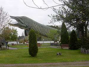
The National Fresh Water Fishing Hall of Fame is located in Hayward. It contains a 143-foot (44 m) fiberglass musky, the world's largest fiberglass structure.[15] Tourists can climb up into the mouth of the fish, and look over the town, as well as Lake Hayward. In addition to fishing, Hayward is also a hot spot for deer hunting, golfing, cross-country skiing, snowmobiling, canoeing, kayaking, horseback riding, and road and mountain biking.
Sawyer County, where Hayward is located, has over 600 miles of groomed snowmobile trails, including 335 miles that run through county forests and connect with trails in adjoining counties.[16][17]
ATV (quad bikes) riding along existing county forest logging roads is permitted. There are 95.7 miles of state-funded ATV trails for winter use and 80.8 miles designated for summer use. State owned trails include the Tuscobia Trail (51 miles), which runs from the Flambeau River to the western county line and the Dead Horse Connector (38 miles) in the eastern Flambeau Forest. The trail system also connects to 140 miles of trail within the Chequamegon National Forest. Hayward allows ATVs on some roads within the city.[16][18]
The annual Chequamegon Fat Tire Festival is the largest mass start mountain bike race in the United States. The first Fat Tire Festival was held in 1983 with 27 riders, and in 2008 the race was capped at 2500 competitors. The two main races include the 40-mile “Chequamegon 40”, and the 16-mile “Short and Fat.”[19]
Participants in the annual Lumberjack World Championships compete in a variety of lumberjack games such as log rolling, chopping, sawing, and chainsaw events.
Hayward hosts the American Birkebeiner cross-country skiing race, the largest cross country ski marathon in North America.[20] The American Birkebeiner first started in 1973. No U.S. Ski Team members were in it, or any foreign skiers. It was unknown then. But today over 13,000 skiers race every year.[21] It is one of Haywards largest and most popular tourist attractions.
The Lac Courte Oreilles Band of Ojibwe host several powwows throughout the year. The largest pow-wow in North America is held annually in the third weekend of July in Hayward. The Honor the Earth Pow-wow honors mother Earth and the Creator.[22]
Media
- The Sawyer County Record is the local newspaper, published every Wednesday.
Radio
- WHSM (AM) 910 and WHSM-FM 101.1, owned by Red Rock Radio
- WRLS-FM 92.3, owned by Vacationland Broadcasting
- WOJB-FM 88.9, owned by the Lac Courte Oreilles Band of Ojibwe
Television
Stations received in Hayward that are from the Duluth area:
Education
Hayward High School and Hayward Middle School serve the community. Lac Courte Oreilles Ojibwa Community College offers several degrees.
Sister city
Hayward officially has one sister city:
Notable people
- Fritz Ackley, MLB player
- U.S. Supreme Court Justice Harry Blackmun had a summer home on Spider Lake[23]
- Al Capone, Chicago gangster, owned a hideaway-retreat near Hayward/Couderay in the 1920s and 1930s.[24]
- Nate DeLong, NBA player
- Jim Denomie, artist
- Sean Duffy, reality television star, ESPN commentator, U.S. House of Representatives, representing the 7th District of Wisconsin
- Dan Plante, NHL player
- Henry Reich, physicist and creator of the YouTube channel MinutePhysics
- Daniel E. Riordan, Wisconsin State Senator
- Randy Sabien, musician/songwriter
- J. R. Salzman, world champion logroller
References
- ↑ "City Officials". cityofhaywardwi.gov. Retrieved November 5, 2014.
- 1 2 "US Gazetteer files 2010". United States Census Bureau. Retrieved 2012-11-18.
- 1 2 "American FactFinder". United States Census Bureau. Retrieved 2012-11-18.
- ↑ "Population Estimates". United States Census Bureau. Retrieved 2013-06-24.
- ↑ US Postal Service – ZIP Codes
- ↑ North American Numbering Plan Administration
- 1 2 "American FactFinder". United States Census Bureau. Retrieved 2008-01-31.
- ↑ "US Board on Geographic Names". United States Geological Survey. 2007-10-25. Retrieved 2008-01-31.
- ↑ "Origin of the name Hayward". Wisconsin Historical Society, Dictionary of Wisconsin History.
- ↑ Chicago and North Western Railway Company (1908). A History of the Origin of the Place Names Connected with the Chicago & North Western and Chicago, St. Paul, Minneapolis & Omaha Railways. p. 178.
- ↑ History of Education in Sawyer County, Wisconsin by J. G. Adams (M.E. Granger, 1902)
- ↑ "US Gazetteer files: 2010, 2000, and 1990". United States Census Bureau. 2011-02-12. Retrieved 2011-04-23.
- ↑ "Annual Estimates of the Resident Population for Incorporated Places: April 1, 2010 to July 1, 2015". Retrieved July 2, 2016.
- ↑ "Census of Population and Housing". Census.gov. Retrieved June 4, 2015.
- ↑ Dregni, Eric (2006). Midwest Marvels: Roadside Attractions Across Iowa, Minnesota, the Dakotas, and Wisconsin. U of Minnesota Press. p. 365. ISBN 978-0-8166-4290-8.
- 1 2 "Sawyer County Snowmobile & ATV Alliance".
- ↑ "Wisconsin Department of Natural Resources snowmobiling information" (PDF).
- ↑ "Sawyer County Land & Water Use Planning 2014 to 2020" (PDF).
- ↑ Fat Tire Festival website
- ↑ Kaye, Nick (27 January 2006). "Not All Downhill (Not Even Mostly)". The New York Times.
- ↑ "About the American Birkebeiner Ski Foundation and History". birkie.com. Retrieved November 5, 2014.
- ↑ "Pow-wow".
- ↑ Greenhouse, Linda (2005). Becoming Justice Blackmun. Times Boks. p. 248. ISBN 0-8050-7791-X.
- ↑ Morey, Joe (February 2, 2010). "Councilman reports on Hideout and other issues at the Directors Meeting". Archived from the original on March 5, 2012.
External links
- City of Hayward official website
- Hayward Area Chamber of Commerce
- Sawyer County Record – local newspaper
- Sanborn fire insurance maps: 1892 1898 1909
Municipalities and communities of Sawyer County, Wisconsin, United States | ||
|---|---|---|
| City | 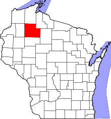 | |
| Villages | ||
| Towns | ||
| CDPs | ||
| Unincorporated communities | ||
| Indian reservation | ||
| Footnotes | ‡This populated place also has portions in an adjacent county or counties | |