Hay Inclined Plane

The Hay Inclined Plane is a canal inclined plane in the Ironbridge Gorge in Shropshire, with a height of 207 feet (63 m). It was located on a short stretch of the Shropshire Canal that linked the industrial area of Blists Hill with the River Severn. The inclined plane was in operation from 1792 to 1894. It can be visited as part of the Blists Hill Victorian Town and is also a waypoint on the South Telford Heritage Trail.
Operation
The Shropshire Canal used box-shaped tub boats 20 feet long with a load capacity of 5 tons. Twin railway tracks were laid down the incline. The tub boats ascended and descended the inclined plane on wheeled cradles which ran on the rails. At the bottom of the incline the rails went underwater allowing the cradle to become submerged and the tub boat to either float free or be floated into position. At the top of the incline the rails also started under water then climbed a short slope out of the water to the top of the incline.
In operation an empty boat would be loaded into the bottom cradle and a full boat would be loaded into the top cradle. A rope would be attached to the loaded top cradle and it would be drawn out of the water to the top of the incline using a small winding drum driven by a steam engine. The main incline rope would then be attached to the cradle and the loaded boat would descend the incline, counterbalanced by an empty boat ascending on the other rail line. The speed would be controlled by a brake on the main winding drum. On reaching the summit a rope from the small winding drum would be attached to the cradle to control its descent into the upper basin.
Although the loaded boats were travelling downhill, and so the plane was mostly worked by gravity, a small steam engine was also provided and drove the winding drums. This was of Heslop's design, a twin-cylindered rotative beam engine, to a design patented in 1790. The remains of the brick boiler house and winding mechanism may be seen at the top of the incline.
 The Hay Inclined Plane
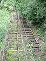
 Top of the incline, showing original-pattern bridge rail. The normal water level is shown by the extent of the staining on the wall[1]
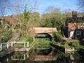 The Coalport Canal at the bottom of the plane
See also
Further reading
- Uhlemann, Hans-Joachim (2002). Canal lifts and inclines of the world (English Translation ed.). Internat. ISBN 0-9543181-1-0.
References
External links
| Wikimedia Commons has media related to Hay inclined plane. |
- "Hay Inclined Plane".
- "International Canal Monuments List".
- "Inclined Plane Photo".
- "Inclined Plane Photos".
Coordinates: 52°37′16″N 2°27′09″W / 52.6212°N 2.4525°W