Hauterives
Hauterives is also a village part of the commune of Sainte-Enimie, in the Lozère department.
| Hauterives | ||
|---|---|---|
|
Cheval's "Palais Idéal" | ||
| ||
 Hauterives | ||
|
Location within Auvergne-Rhône-Alpes region  Hauterives | ||
| Coordinates: 45°15′22″N 5°01′38″E / 45.2561°N 5.0272°ECoordinates: 45°15′22″N 5°01′38″E / 45.2561°N 5.0272°E | ||
| Country | France | |
| Region | Auvergne-Rhône-Alpes | |
| Department | Drôme | |
| Arrondissement | Valence | |
| Canton | Le Grand-Serre | |
| Government | ||
| • Mayor (2008–2014) | Gabriel Biancheri | |
| Area1 | 30.51 km2 (11.78 sq mi) | |
| Population (2008)2 | 1,584 | |
| • Density | 52/km2 (130/sq mi) | |
| Time zone | CET (UTC+1) | |
| • Summer (DST) | CEST (UTC+2) | |
| INSEE/Postal code | 26148 / 26390 | |
| Elevation |
269–506 m (883–1,660 ft) (avg. 346 m or 1,135 ft) | |
|
1 French Land Register data, which excludes lakes, ponds, glaciers > 1 km² (0.386 sq mi or 247 acres) and river estuaries. 2 Population without double counting: residents of multiple communes (e.g., students and military personnel) only counted once. | ||
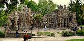

Hauterives is a commune in the Drôme department in southeastern France. It is home to Ferdinand Cheval's self-made Ideal Palace.
Geography
The Galaure flows southwest through the middle of the commune.
Population
| Historical population | ||
|---|---|---|
| Year | Pop. | ±% |
| 1790 | 1,588 | — |
| 1911 | 1,747 | +10.0% |
| 1962 | 1,173 | −32.9% |
| 1968 | 1,123 | −4.3% |
| 1975 | 1,081 | −3.7% |
| 1982 | 1,096 | +1.4% |
| 1990 | 1,202 | +9.7% |
| 1999 | 1,333 | +10.9% |
| 2008 | 1,584 | +18.8% |
See also
References
| Wikimedia Commons has media related to Hauterives. |
This article is issued from Wikipedia - version of the 10/28/2016. The text is available under the Creative Commons Attribution/Share Alike but additional terms may apply for the media files.