Hatun Pukara
| Hatun Pukara | |
|---|---|
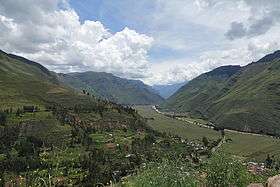 The northern slope of Hatun Pukara (on the left), the village of Taray and the Willkanuta valley as seen from Ñustapata | |
| Highest point | |
| Elevation | 4,000 m (13,000 ft) [1] |
| Coordinates | 13°26′23″S 71°53′18″W / 13.43972°S 71.88833°WCoordinates: 13°26′23″S 71°53′18″W / 13.43972°S 71.88833°W |
| Geography | |
 Hatun Pukara Peru | |
| Location | Peru, Cusco Region |
| Parent range | Andes |
Hatun Pukara (Quechua hatun big, pukara fortress,[2] "big fortress", hispanicized spelling Jatun Pucará) is a mountain in the Andes of Peru, about 4,000 metres (13,123 ft) high. It is located in the Cusco Region, Calca Province, on the border of the districts of Coya and Taray, southwest of Taray. It lies south of the Willkanuta River.[1]
References
This article is issued from Wikipedia - version of the 12/6/2015. The text is available under the Creative Commons Attribution/Share Alike but additional terms may apply for the media files.