Hatton (Warwickshire) railway station
| Hatton | |
|---|---|
|
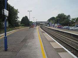
Hatton railway station in 2013. | |
| Location | |
| Place | Shrewley |
| Local authority | District of Warwick |
| Grid reference | SP224663 |
| Operations | |
| Station code | HTN |
| Managed by | Chiltern Railways |
| Number of platforms | 3 |
| DfT category | F1 |
|
Live arrivals/departures, station information and onward connections from National Rail Enquiries | |
| Annual rail passenger usage* | |
| 2004/05 |
|
| 2005/06 |
|
| 2006/07 |
|
| 2007/08 |
|
| 2008/09 |
|
| 2009/10 |
|
| 2010/11 |
|
| 2011/12 |
|
| 2012/13 |
|
| 2013/14 |
|
| 2014/15 |
|
| History | |
| Key dates | Opened 1852 |
| National Rail – UK railway stations | |
| * Annual estimated passenger usage based on sales of tickets in stated financial year(s) which end or originate at Hatton from Office of Rail and Road statistics. Methodology may vary year on year. | |
|
| |
Hatton railway station takes the name of the village of Hatton in Warwickshire, England, although it is about 1 mile (1.6 km) from the village. The nearest settlement is Little Shrewley. The station is managed by Chiltern Railways. Most trains calling here are those provided by Chiltern on its London Marylebone/Leamington Spa/Birmingham Snow Hill/Kidderminster and London Marylebone/Leamington Spa/Stratford routes, but these are augmented by a few London Midland services.
Hatton is the junction station at which the lines from Leamington Spa to Stratford-upon-Avon and Birmingham diverge. The station is unstaffed; ticketing is restricted to a 'Permit-to-Travel' machine located at the single entrance to the station on the London-bound (southbound) platform. There is a small shelter on the southbound platform 1 and also one on the island platform (platform 2 for Birmingham-bound services and platform 3 for stations to Stratford upon Avon which bear to the west immediately north of the station. A footbridge links platform 1 with island platform 2/3).
Each platform at the station is equipped with a real-time electronic information departure screen.
History
The station dates from 1852 (being opened by the Birmingham and Oxford Junction Railway), with the branch to Stratford via Bearley Junction opening in 1860 (this had a later extension from Bearley Junction to Alcester added in 1876).[1] It sits part way along a 5-mile (8 km) long rising section of line with a ruling gradient of 1 in 110 for northbound trains known as Hatton Bank - this section was often difficult to negotiate for heavy freights and the use of banking engines was commonplace. The station had its platforms extended in 1892 and further remodelling of the track in the area would follow over the next two decades. By 1939 the branch had been doubled, but the western end to Alcester was closed in 1951 and it reverted to single track in 1969, when signalling control was transferred to the newly commissioned panel box at Saltley.[1]
Services
The station is served primarily by the Chiltern Railways two-hourly Birmingham Moor Street to Leamington Spa local service and the two-hourly Leamington Spa to Stratford-Upon-Avon service during Monday-Saturday daytimes. The base pattern is however enhanced at peak times, with extra calls by Snow Hill - Marylebone trains, and London Midland stopping services between Leamington Spa and Stourbridge Junction/Kidderminster. On Sundays, there is one train per hour to Leamington & London and every two hours to Stratford and Birmingham.[2]
References
- 1 2 Warwickshire Railways - Hatton stationWarwickshire Railways; Retrieved 12 October 2016
- ↑ GB National Railway Timetable 2016 Edition, Table 71
External links
| Wikimedia Commons has media related to Hatton (Warwickshire) railway station. |
- Train times and station information for Hatton (Warwickshire) railway station from National Rail
- Historical photographs of Hatton station at warwickshirerailways.com
- Rail Around Birmingham and the West Midlands: Hatton station
| Preceding station | |
Following station | ||
|---|---|---|---|---|
| Lapworth Limited Service |
London Midland Leamington-Worcester |
Warwick Parkway Limited Service | ||
| Lapworth | Chiltern Railways London to Birmingham |
Warwick Parkway | ||
| Claverdon Limited Service |
Chiltern Railways Leamington Spa to Stratford |
|||
Coordinates: 52°17′43″N 1°40′23″W / 52.2952°N 1.6730°W