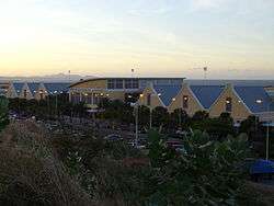
Curaçao International Airport
| Hato International Airport Curaçao International Airport | |||||||||||
|---|---|---|---|---|---|---|---|---|---|---|---|
 | |||||||||||
| IATA: CUR – ICAO: TNCC | |||||||||||
| Summary | |||||||||||
| Airport type | Public | ||||||||||
| Owner | Curaçao Airport Holding | ||||||||||
| Operator | Curaçao Airport Partners | ||||||||||
| Serves | Curaçao | ||||||||||
| Location | Willemstad, Curaçao | ||||||||||
| Hub for | |||||||||||
| Elevation AMSL | 29 ft / 9 m | ||||||||||
| Coordinates | 12°11′20″N 068°57′35″W / 12.18889°N 68.95972°WCoordinates: 12°11′20″N 068°57′35″W / 12.18889°N 68.95972°W | ||||||||||
| Website | curacao-airport.com | ||||||||||
| Map | |||||||||||
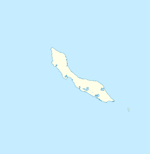 CUR Location in Curaçao | |||||||||||
| Runways | |||||||||||
| |||||||||||
| Statistics (2015) | |||||||||||
| |||||||||||
Hato International Airport or Curaçao International Airport (formerly Dr. Albert Plesman International Airport) (IATA: CUR, ICAO: TNCC) is the airport of Willemstad, Curaçao. It has services to the Caribbean region, South America, North America and Europe. Hato Airport is a fairly large facility, with the third longest commercial runway in the Caribbean region after Rafael Hernández Airport in Puerto Rico and Pointe-à-Pitre International Airport in Guadeloupe. The airport serves as a main base for Insel Air.
History
World War II
During World War II, the airport was used by the United States Army Air Forces Sixth Air Force conducting antisubmarine patrols. Flying units using the airfield were:
- 59th Bombardment Squadron (VI Bomber Command) 10 March 1942 – 13 July 1943 (A-20 Havoc)
- 32d Fighter Squadron (36th Fighter Group, Antilles Air Command, XXVI Fighter Command) 9 March 1943 – 13 March 1944, (P-40 Warhawk)
- Detachment operated from: Dakota Field, Aruba, 9 March 1943 – 9 March 1944
- Detachment operated from: Losey Army Airfield, Puerto Rico, 9 March-4 June 1944
- 25th Bombardment Group (VI Bomber Command), 1 August-5 October 1943
Later development
A new terminal was officially opened in 2006 and it accommodates a maximum of 1.6 million passengers per year.[3]
Airlines and destinations
Passenger
- Notes
- ^1 KLM's flights operate from Sint Maarten to Curaçao on selected days. However, the airline does not have cabotage rights to transport passengers solely between Sint Maarten and Curaçao.
- ^2 PAWA Dominicana's flights operate to and from Aruba. However, the airline does not have cabotage rights to transport passengers solely between Aruba and Curaçao.
- ^3 TUI Airlines Netherlands's flights operate between Aruba, Bonaire and Curaçao on selected days. However, the airline does not have cabotage rights to transport passengers solely between Aruba, Bonaire and Curaçao.
Cargo
| Airlines | Destinations |
|---|---|
| Ameriflight | Aguadilla, Aruba, Caracas, San Juan |
| Amerijet International | Miami |
| Aerosucre | Bogota |
| Emirates | Amsterdam1 |
| Lineas Aereas Suramericanas | Bogota |
| Vensecar Internacional | Caracas |
- Notes
- ^1 Emirates's flight operates from Quito to Curaçao as a fuel stop, to continue to Amsterdam and Dubai.
Coast Guard Air Station Hato
Located at the west side of Hato Airport there are hangars for the two Bombardier Dash 8 Maritime Patrol Aircraft and two AgustaWestland AW139 helicopters of the Dutch Caribbean Coast Guard. This was until 2007 a naval airbase of the Royal Netherlands Navy who operated the base for 55 years. With a wide variety of aircraft in the past years Fireflies, Avengers, Trackers, Neptunes, Fokker F-27's, P-3C Orions, Fokker F-60's and several helicopters. After the political decision to sell all Orions the airbase wasn't needed anymore.
The west end of the airport is a USAF Forward Operating Base (FOB). The base hosts AWACS and transport aircraft. Until 1999 the USAF operated a small fleet of F-16 fighters from the FOB.
References
![]() This article incorporates public domain material from the Air Force Historical Research Agency website http://www.afhra.af.mil/.
This article incorporates public domain material from the Air Force Historical Research Agency website http://www.afhra.af.mil/.
- ↑ Airport information for TNCC at World Aero Data. Data current as of October 2006.Source: DAFIF.
- ↑ Curaçao factsheet. Zurich Airport.
- ↑ Curaçao International Airport (official website)
- ↑ http://www.entornointeligente.com/articulo/8345653/Curacao-Aruba-Airlines/
- Maurer, Maurer, ed. (1982) [1969]. Combat Squadrons of the Air Force, World War II (PDF) (reprint ed.). Washington, DC: Office of Air Force History. ISBN 0-405-12194-6. LCCN 70605402. OCLC 72556.
External links
- Airport information for TNCC at Great Circle Mapper. Source: DAFIF (effective October 2006).
- Accident history for CUR at Aviation Safety Network
Previously: Panama Canal Air Force (1940-1941); Caribbean Air Force (1941-1942) | |||||||||||||||||||||||||
| Airfields |
| .jpg) | |||||||||||||||||||||||
| Units |
| ||||||||||||||||||||||||