Hastings Lake, Alberta
| Hastings Lake | |
|---|---|
| Hamlet | |
|
Hastings Lake | |
 Hastings Lake Location of Hastings lake in Alberta | |
| Coordinates: 53°24′31″N 112°54′7″W / 53.40861°N 112.90194°WCoordinates: 53°24′31″N 112°54′7″W / 53.40861°N 112.90194°W | |
| Country |
|
| Province |
|
| Region | Edmonton Region |
| Census division | 11 |
| Specialized municipality | Strathcona County |
| Settled | 1884 |
| Government | |
| • Type | Unincorporated |
| • Mayor | Roxanne Carr |
| • Governing body |
Strathcona County Council
|
| Elevation | 744 m (2,441 ft) |
| Time zone | MST (UTC-7) |
| • Summer (DST) | MDT (UTC-6) |
| Postal code span | T8G |
| Area code(s) | +1-780 |
| Highways | Highway 14 |
| Website | Strathcona County |
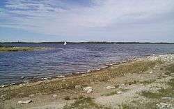
Hastings Lake is a hamlet in Alberta, Canada within Strathcona County.[1] It is located on the south shore of Hastings Lake, approximately 40 kilometres (25 mi) southeast of Sherwood Park. It is 1.5 kilometres (0.93 mi) north of Highway 14.
The lake was renamed in 1884 for Tom Hastings, a member of Tyrell's geological survey party. The original name was Kawtikh, which in the Cree language means "the lake that does not freeze".
The large forested area in the Hastings Lake Watershed is a key area for moose and white-tailed deer. With close proximity to the Cooking Lake-Blackfoot Wildlife, Grazing and Provincial Recreation Area and the Waskahegan Staging Area, many hiking and cross-country skiing possibilities exists.[2]
Demographics
The population of Hastings Lake according to Strathcona County's 2015 municipal census is 87.[3]
See also
References
- ↑ Alberta Municipal Affairs (2010-04-01). "Specialized and Rural Municipalities and Their Communities" (PDF). Retrieved 2010-07-04.
- ↑ Hastings Lake
- ↑ "Census 2015: Overall Results" (PDF). Strathcona County. p. 4. Retrieved June 1, 2016.