Hassocks railway station
| Hassocks | |
|---|---|
 | |
| Location | |
| Place | Hassocks |
| Local authority | District of Mid Sussex |
| Grid reference | TQ304155 |
| Operations | |
| Station code | HSK |
| Managed by | Southern |
| Number of platforms | 2 |
| DfT category | C2 |
|
Live arrivals/departures, station information and onward connections from National Rail Enquiries | |
| Annual rail passenger usage* | |
| 2004/05 | 0.843 million |
| 2005/06 |
|
| 2006/07 |
|
| 2007/08 |
|
| 2008/09 |
|
| 2009/10 |
|
| 2010/11 |
|
| 2011/12 |
|
| 2012/13 |
|
| 2013/14 |
|
| 2014/15 |
|
| History | |
| 21 September 1841 | Opened (Hassocks Gate) |
| 1 October 1881 | Renamed (Hassocks) |
| 1973 [1] | Rebuilt |
| National Rail – UK railway stations | |
| * Annual estimated passenger usage based on sales of tickets in stated financial year(s) which end or originate at Hassocks from Office of Rail and Road statistics. Methodology may vary year on year. | |
|
| |
Hassocks railway station serves Hassocks in West Sussex, England. It is on the Brighton Main Line and Thameslink 7 1⁄4 miles (11.7 km) north of Brighton railway station, and train services are provided by Southern and Thameslink.
History

The station was named "Hassocks Gate" upon its opening on 21 September 1841 by the London and Brighton Railway,[2] which became the London Brighton and South Coast Railway in 1846. It was one of the few intermediate stations on the line with four tracks, to allow express trains to overtake those stopping at the station.[3] However, the number of tracks was later reduced to two, although the additional width is still apparent from the siting of the station buildings.
The original 1841 station building was designed by David Mocatta, the architect of the railway, in a simple cottage style, but using the same modular system that he applied to other stations on the line.[4]
For many years Hassocks Gate station was used by excursion trains for passengers visiting the nearby South Downs and suffered as a result as it became a meeting place for prostitutes. It stands almost at the summit of the line's climb from London before passing through Clayton Tunnel, a short distance south of the station. This was the site of the Clayton Tunnel rail crash in 1861, resulting in 23 deaths and 176 injuries.
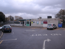
Between December 1880 and August 1881 a new station building was constructed by James Longley & Co of Crawley to the designs of Thomas Myres as the prototype for those later built in the same style on the Bluebell and Cuckoo line[5] with a half-timbered upper storey, decorative brick eaves, stained glass windows and charming porches. The booking office was covered by a lantern-shaped roof and the platforms by wooden canopies on iron columns. The station was demolished in 1973 by British Rail and replaced with a CLASP structure which has been described as "truly awful".[6]
In 2006 the local community announced that it was hoping to raise £2.5m to rebuild the station to the previous design.[1]
These plans seem to have fallen through as in 2008 Network Rail announced that it would be carrying out an 18-month feasibility study to identify possible improvements to the existing building in order to facilitate access by the disabled and elderly.[7] Recent changes (2011) to the station have seen the addition of ticket gate lines on both platforms and some refurbishment of the shelters. In January 2011 it was announced by Network Rail that "£1.25 million will be used to rebuild the station under the Department for Transport’s National Station Improvement Programme and that a further £1.6 million, from the Access for All scheme, will be used to install step-free access."[8]
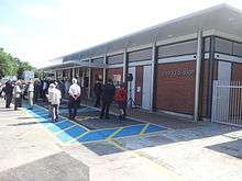
Work began on building the new station in November 2012 and the new ticket office opened for the first time on 14 June 2013. Whilst there is still work to be completed such as the lifts to improve access the opening of the new station officially took place on Friday 5 July 2013, conducted by the MD of Southern and Catherine Cassidy.[9] Contractors expect to be completely finished in December 2013.
The station features in Sabine Baring-Gould's mid-Victorian ghost story The 9.30 Up-train.[10]
Services
The typical service from the station is:
- 3tph southbound to Brighton;
- 2tph northbound to Bedford via East Croydon, St Pancras International and Luton;
- 1tph northbound to London Victoria via East Croydon and Clapham Junction.
On Sundays the service is similar.
| Preceding station | |
Following station | ||
|---|---|---|---|---|
| Gatwick Airport or Burgess Hill |
Southern Brighton Main Line |
Preston Park or Brighton | ||
| Thameslink Thameslink |
||||
| Wivelsfield or Burgess Hill |
Southern Gatwick Express Peak Times Only |
Preston Park or Brighton | ||
References
- 1 2 BBC News 19 May 2006
- ↑ The London and Brighton railway guide, containing a correct description of the railway, historical and topographical notices of the places contiguous to the various stations, etc. London: J.R. Jobbins. 1841. p. 40. JSTOR 60240078.
- ↑ Howard Turner, John (1979). The London Brighton and South Coast Railway 3 Completion and Maturity. Batsford. p. 126. ISBN 0-7134-1389-1.
- ↑ Howard Turner, John (1977). The London Brighton and South Coast Railway 1 Origins and Formation. Batsford. p. 128 and plate 10. ISBN 0-7134-0275-X.
- ↑ Green, Alan H. J. (July 2013). "The railway buildings of T. H. Myres". Newsletter of the Sussex Industrial Archaeology Society (159): 12.
- ↑ Sussex Industrial Archaeology Society
- ↑ Mid Sussex Times, "More funding for Hassocks station", 7 February 2008.
- ↑ Hassocks Station in line for multi-million pound facelift (From The Argus)
- ↑ "New Hassocks station open for business". Southern Railway. 5 July 2013. Retrieved 11 October 2013.
- ↑ http://en.wikisource.org/wiki/A_Book_of_Ghosts/The_9.30_Up-train. There is a degree of confusion as to the date of this story. In A Book of Ghosts, Baring-Gould says it was first published in 1853. The story is however set in June 1860 and, furthermore, makes passing reference to the Clayton Tunnel railway disaster of August 1861.
External links
- Train times and station information for Hassocks railway station from National Rail
Coordinates: 50°55′30″N 00°08′45″W / 50.92500°N 0.14583°W