Hasselwood Rock
|
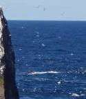
Hasselwood Rock visible as breaking waves to the north of Rockall | |
 Hasselwood Rock | |
| Geography | |
|---|---|
| Location | North Atlantic |
| Coordinates | 57°35′58″N 13°41′19″W / 57.59944°N 13.68861°WCoordinates: 57°35′58″N 13°41′19″W / 57.59944°N 13.68861°W |
| Area | 300 m2 (3,200 sq ft) |
| Highest elevation | 1 m (3 ft) |
| Administration | |
Hasselwood Rock is a skerry adjacent to Rockall in the North Atlantic.
Position and characteristics
Its upper part is the destroyed cone of an extinct volcano, 200 metres (656 feet) north of the larger outcrop of Rockall.[1]
The rock is approximately 1 metre above low water, 13 metres in diameter, with an area of approximately 130 square metres. It is covered at high tide and in heavy seas, often only visible as breaking waves. There are no sources of fresh water on the rock, which is uninhabitable. The only other rocks in the area, those of Helen's Reef, are almost 2 kilometres to the north-east.
Expeditions and landings have not been reported. The geological composition is unknown.[1]
History
The brigantine Helen of Dundee, bound for Quebec, foundered at Hasselwood Rock in 1824; "the crew left most of the passengers to drown, including seven women and six children".
On 28 June 1904, SS Norge, a Danish passenger liner, ran aground on Hasselwood Rock. Over 635 people died during the sinking, among them 225 Norwegians
_p0231_ROCKALL.jpg)
References
- 1 2 G. S. Holland and R. A.Gardiner. The First Map of Rockall. The Geographic Journal, v.141, n.1 (March 1975). pp. 94-98.