Haselbury Plucknett
| Haselbury Plucknett | |
 Haselbury House |
|
 Haselbury Plucknett first school |
|
 Haselbury Plucknett |
|
| Population | 744 (2011)[1] |
|---|---|
| OS grid reference | ST475105 |
| District | South Somerset |
| Shire county | Somerset |
| Region | South West |
| Country | England |
| Sovereign state | United Kingdom |
| Post town | Crewkerne |
| Postcode district | TA18 |
| Dialling code | 01460 |
| Police | Avon and Somerset |
| Fire | Devon and Somerset |
| Ambulance | South Western |
| EU Parliament | South West England |
| UK Parliament | Yeovil |
Coordinates: 50°53′29″N 2°44′52″W / 50.8915°N 2.7478°W
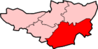
Haselbury Plucknett is a village and civil parish on the River Parrett in Somerset, England, situated 6 miles (9.7 km) south west of Yeovil in the South Somerset district. The village has a population of 744.[1]
It is the final resting place of 'Blessed' Wulfric, who was never formally canonised, and who died 20 February 1154.
The village has a small primary school, run by the Church of England. It did have a small village shop and post office, however this closed in September 2009. The only pub/restaurant in the village is The White Horse at Haselbury.
History
The first part of the village name means a hazel grove and the second part from the name of its medieval owners.[2]
It was one of the few manors which retained its Saxon owner, Brismar, after the Norman Conquest. A later Lord of the manor, Richard of Haselbury, rebelled against King John and was hanged at Sherborne.[2]
Saint Wulfric arrived in the village in 1125 and was visited by Henry I and other nobility. He died in 1154 and was buried in the east end of the north aisle of the church, which became known as St Wufric's aisle, but there is no trace in the current church.[2]
The parish was part of the hundred of Houndsborough.[3]
Haselbury Bridge (sometimes called Haslebury Old Bridge) is a stone built bridge dating from the 14th century. It is a scheduled monument and Grade II* listed building.[4][5] The two arch bridge was built of local Hamstone and carries a small road over the River Parrett.[6] Each of the arches has a 3 metres (9.8 ft) span. The bridge is 4.1 metres (13 ft) wide including the parapet on each side.[4] In the 17th century it carried the main route between Salisbury and Exeter and later marked the boundary between the Chard and Yeovil Turnpike trusts.[5][7][8] The bridge was bypassed in 1831.[9]
Governance
The parish council has responsibility for local issues, including setting an annual precept (local rate) to cover the council's operating costs and producing annual accounts for public scrutiny. The parish council evaluates local planning applications and works with the local police, district council officers, and Neighbourhood Watch groups on matters of crime, security, and traffic. The parish council's role also includes initiating projects for the maintenance and repair of parish facilities, as well as consulting with the district council on the maintenance, repair, and improvement of highways, drainage, footpaths, public transport, and street cleaning. Conservation matters (including trees and listed buildings) and environmental issues are also the responsibility of the council.
The village falls within the non-metropolitan district of South Somerset, which was formed on 1 April 1974 under the Local Government Act 1972, having previously been part of Yeovil Rural District.[10] The district council ts responsible for local planning and building control, local roads, council housing, environmental health, markets and fairs, refuse collection and recycling, cemeteries and crematoria, leisure services, parks, and tourism.
Somerset County Council is responsible for running the largest and most expensive local services such as education, social services, libraries, main roads, public transport, policing and fire services, trading standards, waste disposal and strategic planning.
It is also part of the Yeovil county constituency represented in the House of Commons of the Parliament of the United Kingdom, electing one Member of Parliament (MP) by the first past the post system of election, and part of the South West England constituency of the European Parliament, which elects seven MEPs using the d'Hondt method of party-list proportional representation.
Notable Residents
- William Best, 1st Baron Wynford PC (1767 – 1845), conservative politician and judge who served as Chief Justice of the Common Pleas from 1824 until 1829[11][12]
Religious sites
The Anglican parish Church of St Michael and All Angels dates from the 14th century.[13]
The village has a small Protestant church. The church still gets a decent congregation when it has services. The nearby local primary school goes there to practise and perform their plays.
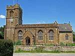 St Michael's Church - Haselbury Plucknett
 Gentlemans Row
 The White Horse Inn
 Village Green
References
- 1 2 "Statistics for Wards, LSOAs and Parishes — SUMMARY Profiles" (Excel). Somerset Intelligence. Retrieved 4 January 2014.
- 1 2 3 Bush, Robin (1994). Somerset: The Complete Guide. Dovecote Press. p. 112. ISBN 1-874336-26-1.
- ↑ "Somerset Hundreds". GENUKI. Retrieved 9 October 2011.
- 1 2 "Haselbury Bridge". National Heritage List for England. English Heritage. Retrieved 22 December 2014.
- 1 2 "Haselbury Old Bridge". National Heritage List for England. English Heritage. Retrieved 22 December 2014.
- ↑ "Haselbury Bridge, Haslebury Plucknett". Somerset Historic Environment Record. Somerset County Council. Retrieved 22 December 2014.
- ↑ Nathan, Matthew (1957). The Annals of West Coker. Cambridge University Press. pp. 444–445.
- ↑ Baggs, A.P.; Bush, R.J.E. "Parishes: Crewkerne". British History Online. Victoria County History. Retrieved 22 December 2014.
- ↑ "Haselbury Bridge". SABRE. Retrieved 22 December 2014.
- ↑ "Yeovil RD". A vision of Britain Through Time. University of Portsmouth. Retrieved 4 January 2014.
- ↑
 Stephen, Leslie, ed. (1885). "Best, William Draper". Dictionary of National Biography. 4. London: Smith, Elder & Co.
 - ↑ "Hoskins family of South Somerset". National Archives. Retrieved 18 June 2013.
- ↑ "Church of St Michael and All Angels". Images of England. English Heritage. Retrieved 11 January 2009.
External links
![]() Media related to Haselbury Plucknett at Wikimedia Commons
Media related to Haselbury Plucknett at Wikimedia Commons