Harvey, North Dakota
| Harvey, North Dakota | |
|---|---|
| City | |
|
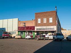
Business district of Harvey | |
| Nickname(s): "Gateway to the Lonetree Wildlife Management Area" | |
| Motto: "A Century of Community Pride & Spirit" "Not Just A Place...It's An Experience!" | |
 Location of Harvey, North Dakota | |
| Coordinates: 47°46′12″N 99°55′52″W / 47.77000°N 99.93111°WCoordinates: 47°46′12″N 99°55′52″W / 47.77000°N 99.93111°W | |
| Country | United States |
| State | North Dakota |
| County | Wells |
| Area[1] | |
| • Total | 1.88 sq mi (4.87 km2) |
| • Land | 1.88 sq mi (4.87 km2) |
| • Water | 0 sq mi (0 km2) |
| Elevation | 1,598 ft (487 m) |
| Population (2010)[2] | |
| • Total | 1,783 |
| • Estimate (2015)[3] | 1,779 |
| • Density | 948.4/sq mi (366.2/km2) |
| Time zone | Central (CST) (UTC-6) |
| • Summer (DST) | CDT (UTC-5) |
| ZIP code | 58341 |
| Area code(s) | 701 |
| FIPS code | 38-35900 |
| GNIS feature ID | 1029328[4] |
| Highways | US 52, US 52 Bus., ND 3, ND 91 |
| Website | www.harveynd.com |
Harvey is a city in Wells County, North Dakota, United States. The population was 1,783 at the 2010 census.[5] Harvey was founded in 1893 as a division point by the Soo Line Railway. According to the book published in 1981 on the 75th anniversary of the town's incorporation as a city in 1906, Harvey, ND is believed to have been named for a director of the Soo Line Railway: Col. Scott William Harvey of Minneapolis, Minnesota.
Geography
Harvey is located at 47°46′12″N 99°55′52″W / 47.77000°N 99.93111°W (47.770045, −99.931121).[6]
According to the United States Census Bureau, the city has a total area of 1.88 square miles (4.87 km2), all of it land.[1]
Demographics
| Historical population | |||
|---|---|---|---|
| Census | Pop. | %± | |
| 1910 | 1,443 | — | |
| 1920 | 1,590 | 10.2% | |
| 1930 | 2,157 | 35.7% | |
| 1940 | 1,851 | −14.2% | |
| 1950 | 2,337 | 26.3% | |
| 1960 | 2,365 | 1.2% | |
| 1970 | 2,361 | −0.2% | |
| 1980 | 2,527 | 7.0% | |
| 1990 | 2,263 | −10.4% | |
| 2000 | 1,989 | −12.1% | |
| 2010 | 1,783 | −10.4% | |
| Est. 2015 | 1,779 | [7] | −0.2% |
| U.S. Decennial Census[8] 2015 Estimate[3] | |||
2010 census
As of the census[2] of 2010, there were 1,783 people, 824 households, and 476 families residing in the city. The population density was 948.4 inhabitants per square mile (366.2/km2). There were 997 housing units at an average density of 530.3 per square mile (204.7/km2). The racial makeup of the city was 98.5% White, 0.1% African American, 0.6% Native American, 0.1% Pacific Islander, 0.1% from other races, and 0.7% from two or more races. Hispanic or Latino of any race were 1.0% of the population.
There were 824 households of which 20.1% had children under the age of 18 living with them, 47.6% were married couples living together, 7.3% had a female householder with no husband present, 2.9% had a male householder with no wife present, and 42.2% were non-families. 39.6% of all households were made up of individuals and 21.5% had someone living alone who was 65 years of age or older. The average household size was 2.03 and the average family size was 2.68.
The median age in the city was 51.5 years. 18.7% of residents were under the age of 18; 4.8% were between the ages of 18 and 24; 17.9% were from 25 to 44; 26.5% were from 45 to 64; and 32.2% were 65 years of age or older. The gender makeup of the city was 45.5% male and 54.5% female.
2000 census
As of the census of 2000, there were 1,989 people, 926 households, and 529 families residing in the city. The population density was 1,031.8 people per square mile (397.9/km²). There were 1,056 housing units at an average density of 547.8 per square mile (211.3/km²). The racial makeup of the city was 99.20% White, 0.50% Native American, 0.15% Asian, 0.05% from other races, and 0.10% from two or more races. Hispanic or Latino of any race were 0.50% of the population.
There were 926 households out of which 21.5% had children under the age of 18 living with them, 49.6% were married couples living together, 5.7% had a female householder with no husband present, and 42.8% were non-families. Of all households 40.7% were made up of individuals and 24.3% had someone living alone who was 65 years of age or older. The average household size was 2.03 and the average family size was 2.73.
In the city the population was spread out with 19.3% under the age of 18, 4.9% from 18 to 24, 21.0% from 25 to 44, 23.1% from 45 to 64, and 31.7% who were 65 years of age or older. The median age was 49 years. For every 100 females there were 84.5 males. For every 100 females age 18 and over, there were 79.0 males.
The median income for a household in the city was $33,017, and the median income for a family was $45,250. Males had a median income of $31,429 versus $16,534 for females. The per capita income for the city was $21,477. About 6.6% of families and 12.0% of the population were below the poverty line, including 8.2% of those under age 18 and 24.4% of those age 65 or over.
Radio
- KHND AM 1470, owned and operated by Three Way Broadcasting.
Education
Harvey Public Schools operates public schools.
Climate
This climatic region is typified by large seasonal temperature differences, with warm to hot (and often humid) summers and cold (sometimes severely cold) winters. According to the Köppen Climate Classification system, Harvey has a humid continental climate, abbreviated "Dfb" on climate maps.[9]
Notable people
- John T. Davies, Minnesota legislator and politician
- Ivan Dmitri (1900–1968), artist, best known for etching the Spirit of St. Louis[10]
- Michael Forest, actor and voice personality
- Patrick E. Haggerty, co-founder of Texas Instruments
- Jud Heathcote, college basketball coach at Michigan State and Montana, coached national championship team in 1979
- Jim Pederson, American football player
See also
- Media in Minot, North Dakota
- Lake Region Radio
- Mighty Og
- North Dakota Highway 91—Shortest Highway in the Nation
References
- 1 2 "US Gazetteer files 2010". United States Census Bureau. Retrieved 2012-06-14.
- 1 2 "American FactFinder". United States Census Bureau. Retrieved 2012-06-14.
- 1 2 "Population Estimates". United States Census Bureau. Retrieved June 3, 2016.
- ↑ "US Board on Geographic Names". United States Geological Survey. 2007-10-25. Retrieved 2008-01-31.
- ↑ "2010 Census Redistricting Data (Public Law 94-171) Summary File". American FactFinder. United States Census Bureau. Retrieved 2 May 2011.
- ↑ "US Gazetteer files: 2010, 2000, and 1990". United States Census Bureau. 2011-02-12. Retrieved 2011-04-23.
- ↑ "Annual Estimates of the Resident Population for Incorporated Places: April 1, 2010 to July 1, 2015". Retrieved July 2, 2016.
- ↑ "U.S. Decennial Census". Census.gov. Retrieved June 11, 2013.
- ↑ Climate Summary for Harvey, North Dakota
- ↑ Morton County Historical Society (1975). Peterson, Marion Plath, ed. Morton prairie roots. Dallas, Texas: Taylor Publishing Co. p. 212. OCLC 2062977.
External links
- City of Harvey official website
- Harvey, North Dakota: community fact survey (1964) from the Digital Horizons website
- Harvey illustrated: Harvey, North Dakota (1907) from the Digital Horizons website
Municipalities and communities of Wells County, North Dakota, United States | ||
|---|---|---|
| Cities | 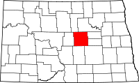 | |
| Townships |
| |
| CDP | ||
| Unincorporated communities | ||