Hartbeespoort Dam
| Hartbeespoort Dam | |
|---|---|
|
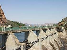
The crest gates added in 1970 | |
 Location of Hartbeespoort Dam in South Africa | |
| Official name | Hartbeespoort Dam |
| Country | South Africa |
| Location | North West Province |
| Coordinates | 25°44′51″S 27°52′1″E / 25.74750°S 27.86694°ECoordinates: 25°44′51″S 27°52′1″E / 25.74750°S 27.86694°E |
| Purpose | Irrigation and domestic use |
| Construction began | 1921[1] |
| Opening date | 1923[1] (renovated: 1969) |
| Owner(s) | Department of Water Affairs |
| Dam and spillways | |
| Type of dam | Arch dam |
| Impounds | Crocodile River |
| Height | 59 m[1] |
| Length | 149.5 m |
| Width (base) | 22 m |
| Reservoir | |
| Creates | Hartbeespoort Dam Reservoir |
| Total capacity | 195,000,000 m3[1] |
| Catchment area | 4 120 km2[1] |
| Surface area | 2 062.8 ha |
Hartbeespoort Dam (also known as Harties) is an arch type dam situated in the North West Province of South Africa. It lies in a valley to the south of the Magaliesberg mountain range and north of the Witwatersberg mountain range, about 35 kilometers west of Pretoria. The name of the dam means "pass of the hartebeest" (a species of antelope) in Afrikaans. This "poort" in the Magaliesberg was a popular spot for hunters, where they cornered and shot the hartebeest.[2] The dam was originally designed for irrigation, which is currently its primary use, as well as for domestic and industrial use.[3] The dam has suffered from a hypertrophic state since the early 1970s. Mismanagement of waste water treatment from urban zones within the Hartbeespoort Dam catchment area is largely to blame, having distorted the food web with over 280 tons of phosphate and nitrate deposits.[4]
The town of Hartbeespoort is situated close to the dam wall and the villages of Kosmos, Melodie, Ifafi, Meerhof and The Coves, Pecanwood, Westlake and several other Estates can be found alongside its banks. the town of Schoemansville was named after General Hendrik Schoeman, owner of the land during the 19th century.[5]
History

| Hartbeespoort Dam bridge | |
|---|---|
| Carries | Motor vehicle traffic |
| Characteristics | |
| Width | Single lane |
| Statistics | |
| Toll | None |
In 1906, the government ordered a public inquiry into the feasibility of building an irrigation dam in the Hartbeespoort of the Magaliesberg. The engineer of the Department of Irrigation that led the inquiry, submitted a favourable report to the government and the Hartebeestpoort Act. 32 of 1914 was accepted by Parliament. As early as 1909 there were test holes drilled at the bottom of the river to determine whether the rock formation was suitable for building such a huge dam. The size of the catchment area was calculated, the water flow was measured and estimates made of the potential irrigable land. Downstream claims to the existing water stream were established. The topography of the riverbank and rock formations were examined to evaluate the viability of the poort for the construction project.[6]
The construction of the dam officially started in August 1916. Initially work was delayed pending a court judgement with General Hendrik Schoeman and a certain Mr. Marshevin about the expropriation of their properties. The dispute was later resolved but discontent remained after a hastily passed law to facilitate the expropriation. In his book "Agter die Magalies", Bertus de Beer argues that the government acted in a heavy-handed manner to resolve a number of issues surrounding the construction of the dam. Mother Nature caused further delays due to flooding. In 1914 and again in 1918, huge amounts of construction wood washed down the river and were never recovered. During 1915, the wall of the Geldenhuysdam further up the river broke and the flooding of the site also caused a delay.
The disruption caused by the First World War, and the complications brought on by the Rebellion of a group of Afrikaners, brought further delays to the building. Then the first company was liquidated due to financial losses resulting from the floods and delays. In 1921 a second company took on the project and appointed an engineer, F. W. Scott, who tackled the project with renewed energy. In April 1923, after all the setbacks and political upheaval, the project was completed. In September of that same year the road over the wall of the Dam and through the tunnel was opened to traffic. The dam first overflowed in March 1925.[7]
The dam was built on the farm Hartebeestpoort, once owned by the Boer General Hendrik Schoeman (1840–1901). The farm and adjacent land were acquired by the State, mainly through the facilitation of his son, Johan Schoeman (1887–1967), around 1912. The completion of the dam made the agricultural land north of the Magaliesberg much more valuable, especially land close to canals and the Krokodil River. As a result, various farms of the Bakwena people of the Tswana ethnic group who lived in the area for many generations were appropriated or lost by various means and white farmers were settled in their place.
Construction

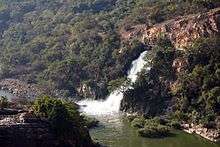
The dam is 149.5 metres (163.5 yd) long and 59.4 metres (195 ft) high and is built across a gorge cutting through the Magaliesberg. The reservoir is fed by the waters of the Crocodile River and Magalies River and covers approximately 18.83 square kilometres (7.27 sq mi), with a mean depth of 9.6 metres (31 ft) and maximum depth of 45.1 metres (148 ft). It has a surface area of 20 square kilometres (7.7 sq mi), and its normal range of annual water level fluctuation is 0.8 metres (2.6 ft). The mixing type of the reservoir is monomictic.[8]
A single-laned, tarmac road skirts the water's edge on the north side; along its route it passes through a 56.6 m long tunnel and also crosses the dam.
Use

Hartbeespoort Dam supplies irrigation water through a 544 kilometres (338 mi) long network of canals to 159.76 square kilometres (61.68 sq mi) of farmland on which tobacco, wheat, lucerne, fruit and flowers are produced.
Hartbeespoort has become a very popular holiday and weekend resort for the inhabitants of Johannesburg and Pretoria; it is the principal water recreation area of northern Gauteng and many types of water sports are enjoyed on the dam. The Transvaal Yacht Club has been operating at the dam since its construction in 1923.[9]
NSRI Station 25, located at the dam, is one of only three National Sea Rescue Institute inland stations and provides a water rescue service at the dam.
Water quality
Hartbeespoort Dam has been renowned for its poor water quality since the mid twentieth century.[10] [11] The Dam suffers severe eutrophication, resulting from high concentrations of phosphates and nitrates in the Crocodile River, the major inflow. The primary pollution sources are industrial and domestic effluent from Gauteng.[12] The catchment area includes Bruma lake in the Jukskei River and Centurion lake in the Hennops River.[13]
The extreme level of eutrophication is evident in excessive growth of microscopic algae and cyanobacteria, and macrophytes such as water hyacinth (Eichhornia crassipes).[14] The South African Department of Water Affairs and Forestry launched the Harties metsi a me (Harties, My Water) programme to find solutions to the water quality problems.[15][16] Budgeted government expenditure from 2004 to 2015 for the clean-up and rehabilitation of the dam and its catchment, and for related community projects, amounts to R900 million.[13] Some biomanipulation methods applied to dams such as Hartbeespoort have come under scientific scrutiny. [17]
See also
References
- 1 2 3 4 5 "Hartbeespoort Dam Integrated Biological Remediation Program" (PDF). Department of Water Affairs and Forestry. 4 September 2008. Retrieved 2008-12-02.
- ↑ de Beer, B. K. (1975). Agter die Magalies. Fontainebleau: Postma Publikasies. p. 381.
- ↑ "SA's Water History – Taming the poort" (PDF). Water Research Commission. June 2008. Retrieved 2010-10-23.
- ↑ "Algae Removal". Department of Water and Sanitation. Retrieved 2015-07-01.
- ↑ Carruthers, Vincent (1990). The Magaliesberg. Johannesburg: Southern Book Publishers. p. 333.
- ↑ de Beer, B. K. (1975). Agter die Magalies. Fontainebleau: Postma Publikasies. p. 387.
- ↑ de Beer, B. K. (1975). Agter die Magalies. Fontainebleau: Postma Publikasies. p. 405.
- ↑ "Limnology of hartbeespoort dam". Council for Scientific and Industrial Research. 1985. Retrieved 2008-12-02.
- ↑ "History". Transvaal Yacht Club. Retrieved 2009-01-22.
- ↑ Allanson BR, Gieskes JMTM. Investigations into the ecology of polluted inland waters in the Transvaal, Part II: An introduction to the limnology of Hartbeespoort Dam with special reference to the effect of industrial and domestic pollution. Hydrobiologia. 1961;18(1–2):77–94.
- ↑ Zohary, T., Jarvis, A. C., Chutter, F. M., Ashton, P. J., Robarts, R. D., 1988. The Hartbeespoort Dam ecosystem programme. Tech. rep., CSIR, WRC. URL http://www.dwa.gov.za/iwqs/eutrophication/Zohary_1988_The_Hartbeespoort_Dam_ecosystem_programme.pdf
- ↑ Harding WR, Thornton JA, Steyn G, Panuska J, Morrison IR. Hartbeespoort Dam Remediation Project (Phase 1) Action Plan Final Report (Volume II). North West Province DACE; 2004. Available from: http://www.dwa.gov.za/harties/
- 1 2 Tempelhoff, Elise (27 December 2012). "Miljoene, maar dam bly nog vuil". Beeld. Retrieved 9 January 2013.
- ↑ Van Ginkel CE, Silberbauer MJ. Temporal trends in total phosphorus, temperature, oxygen, chlorophyll _a_ and phytoplankton populations in Hartbeespoort Dam and Roodeplaat Dam, South Africa, between 1980 and 2000. African Journal of Aquatic Science 32. 2007;1:63–70.
- ↑ "Hartbeespoort Dam Remediation Programme". Department of Water Affairs and Forestry. Retrieved 2008-12-02.
- ↑ "Development of a Resource Management Plan (RMP) for Hartbeespoort Dam is nearing its final stages". South African Government Information. 19 May 2008. Retrieved 2008-12-02.
- ↑ Hart, R. C.; Harding, W. R. (2015). "Impacts of fish on phosphorus budget dynamics of some SA reservoirs: evaluating prospects of 'bottom up' phosphorus reduction in eutrophic systems through fish removal (biomanipulation)". Water SA. 41 (4): 432–440. doi:10.4314/wsa.v41i4.01.
External links
![]() Media related to Hartbeespoort Dam at Wikimedia Commons
Media related to Hartbeespoort Dam at Wikimedia Commons
- Hartbeespoort Dam page at the South African Department of Water Affairs