Harrison, Arkansas
| Harrison, Arkansas | |
|---|---|
| City | |
|
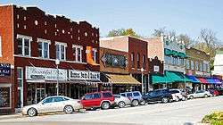
Historic downtown Harrison | |
| Motto: "Adventure Awaits You"[1] | |
 Location in Boone County and the state of Arkansas | |
| Coordinates: 36°14′14″N 93°6′49″W / 36.23722°N 93.11361°WCoordinates: 36°14′14″N 93°6′49″W / 36.23722°N 93.11361°W | |
| Country | United States |
| State | Arkansas |
| County | Boone |
| Platted | 1869 |
| Area | |
| • Total | 11.1 sq mi (28.8 km2) |
| • Land | 11.1 sq mi (28.7 km2) |
| • Water | 0.04 sq mi (0.1 km2) |
| Elevation | 1,050 ft (320 m) |
| Population (2010) | |
| • Total | 12,943 |
| • Density | 1,168/sq mi (451.0/km2) |
| Time zone | Central (CST) (UTC-6) |
| • Summer (DST) | CDT (UTC-5) |
| ZIP codes | 72601-72602 |
| Area code(s) | 870 |
| FIPS code | 05-30460 |
| GNIS feature ID | 0077134 |
| Website |
cityofharrison |
Harrison is a city in Boone County, Arkansas, United States. It is the county seat. It named after General Marcus LaRue Harrison, a surveyor that laid out the city along Crooked Creek at Stifler Springs.[2] According to 2012 Census Bureau estimates, the population of the city was 13,163,[3] up from 12,943 at the 2010 census.[4]
Harrison is the principal city of the Harrison Micropolitan Statistical Area, which includes all of Boone and Newton counties.
History
Native Americans were the first inhabitants of the area, the first probably being cliff dwellers who lived in caves in the bluffs along the rivers. In later times, the Osage, a branch of the Sioux, was the main tribe in the Ozarks, and one of their larger villages is thought to have been to the east of the present site of Harrison. The Shawnee, Quapaw, and Caddo people were also familiar to the area.
The Cherokee arrived around 1816 and did not get along with the Osage. This hostility erupted into a full-scale war in the Ozark Mountains. By the 1830s both tribes were removed to Indian Territory. It is possible that the first white men to visit the area were some forty followers of Hernando de Soto and that they camped at a Native village on the White River at the mouth of Bear Creek. It is more likely that the discoverers were French hunters or trappers who followed the course of the White River.
In early 1857, the Baker-Fancher wagon train assembled at Beller's Stand, south of Harrison. On September 11, 1857, approximately 120 members of this wagon train were murdered near Mountain Meadows, Utah Territory, by attacking local Mormon militia and members of the Paiute Indian tribe. In 1955, a monument to memorialize the victims of the massacre was placed on the Harrison town square.[5]
Boone County was organized in 1869, during Reconstruction after the Civil War. Harrison was platted and made the county seat. It is named after Marcus LaRue Harrison, a Union officer who surveyed and platted the town. The town of Harrison was incorporated on March 1, 1876.[6]
In 1905 and 1909, citizens drove all of the African-American residents and nearly all of the unemployed railroad men (most of whom were African-American) out of Harrison, purportedly to "curb crime".[7] These events were the subject of an Independent Lens program entitled "Banished" on PBS in 2008.[8] The Boone County Courthouse, built in 1909, and the Boone County Jail, built in 1914, were both designed by architect Charles L. Thompson and are listed on the U.S. National Register of Historic Places.
The notorious bank robber and convicted murderer Henry Starr met his fate in Harrison on February 18, 1921, when Starr and three companions entered the People's State Bank and robbed it of $6,000.00. During the robbery, Starr was shot by the former president of the bank, William J. Myers. Starr was carried to the town jail, where he died the next morning.[9]
The Harrison Police Department has had two officers killed in the line of duty, both by gunfire and within a year of one another. The first was officer Ed Williams, killed on a disturbance call on May 25, 1934.[10] The second was Chief of Police Burr Robertson who was killed while arresting a murder suspect at the railroad station on March 27, 1935.[11]
On May 7, 1961, heavy rain caused Crooked Creek, immediately south of the downtown business district, to flood the town square and much of the southwestern part of the city. Water levels inside buildings reached eight feet. Many small buildings and automobiles were swept away. According to the American Red Cross, four lives were lost, 80 percent of the town's business district was destroyed, and over 300 buildings were damaged or destroyed in losses exceeding $5.4 million.[12]
Thomas Robb, national director of the Knights of the Ku Klux Klan, maintains his office near Harrison in the outlying town of Zinc and uses a Harrison mailing address for the organization.[13] Combined with the history of the 1905 and 1909 banishment of unemployed railroad workers and all other African-American residents, this incidental connection to the KKK has given the town a negative image. Some residents have taken steps to combat the image in recent years.[14]

In 2013, a billboard appeared that read: "Anti-Racist is a Code Word for Anti-White. "In response, a local radio station removed its nearby billboard, and students from North Arkansas College passed out fliers calling for a protest of the sign.[15] An official statement read: "The mayor’s office considers the content inflammatory, distasteful and not in line with the truth on how Harrison is a city of welcoming and tolerant citizens."[16]
However, as of October, 2016, the billboard remains displayed.
Geography
U.S. Routes 62, 65, and 412 pass through Harrison. U.S. 65 leads north 33 miles (53 km) to Branson, Missouri, and south 108 miles (174 km) to Conway, Arkansas. U.S. 62 leads west 43 miles (69 km) to Eureka Springs and beyond to Rogers and Bentonville. U.S. 412 leads west 73 miles (117 km) to Springdale. U.S. 62 and 412 combined lead east 48 miles (77 km) to Mountain Home.
According to the United States Census Bureau, the city has a total area of 11.1 square miles (28.8 km2), of which 11.1 square miles (28.7 km2) is land and 0.04 square miles (0.1 km2), or 0.26%, is water.[4]
Demographics
| Historical population | |||
|---|---|---|---|
| Census | Pop. | %± | |
| 1880 | 582 | — | |
| 1890 | 1,438 | 147.1% | |
| 1900 | 1,551 | 7.9% | |
| 1910 | 1,602 | 3.3% | |
| 1920 | 3,477 | 117.0% | |
| 1930 | 3,626 | 4.3% | |
| 1940 | 4,238 | 16.9% | |
| 1950 | 5,542 | 30.8% | |
| 1960 | 6,580 | 18.7% | |
| 1970 | 7,239 | 10.0% | |
| 1980 | 9,567 | 32.2% | |
| 1990 | 9,922 | 3.7% | |
| 2000 | 12,152 | 22.5% | |
| 2010 | 12,943 | 6.5% | |
| Est. 2015 | 13,138 | [17] | 1.5% |
As of the census[19] of 2010, there were 12,943 people and 6,043 housing units in the city. The racial makeup of the city was 96.2% White, 0.3% Black or African American, 0.6% American Indian and Alaska Native, 0.7% Asian, 0.0% Pacific Islander, and 1.6% from two or more races. 2.2% of the population were Hispanic or Latino of any race.
23.2% of the population was under the age of 18, and 19.0% were 65 years of age or older. Females made up 53.1% of the population, and males made up 46.9% of the population.
The median income for the period 2007-11 for a household in the city was $33,244, and the number of people living below the poverty level was 15.1%. The median value of owner-occupied housing units was $108,700.[20]
Economy
Harrison is home to the general office of FedEx Freight FedEx Freight, a leading Less-Than-Load (LTL) freight carrier. Arkansas Freightways, later renamed to American Freightways, was combined with Viking Freight to become FedEx Freight in February 2001.[21]
Walmart store #2 opened in 1965.
Claridge Products and Equipment, Inc., is one of the largest Visual Display Board manufacturers in the world. It has been in business for over 60 years. It is a family-owned business and has been certified as a business owned and controlled by a woman from the National Women Business Owners Corporation (NWBOC).[22]
The Boone County Courthouse, completed in 1909, serves as the heart of the downtown district and is central to Harrison's town square.
Major Employers[23]
- FedEx Freight, Inc. (Trucking and distribution)
- North Arkansas Regional Medical Center (Medical services)
- Walmart, Inc. (Retail)
- Pace Industries (Aluminum die-casting)
- Claridge Products and Equipment , Inc. (Markerboards, chalkboards and bulletin boards)
- Windstream (Telecommunications)
- Wabash Wood Products (Trailer floor manufacturing)
- North Arkansas College (Education)
- Flexsteel Industries, Inc. (Furniture)
- WestRock, formerly RockTenn Company (Folding Paperboard Cartons)
Arts and culture
Annual cultural events
Harrison hosts the annual Arkansas Hot Air Balloon races each September, Crawdad Days Music Festival each May, a Harvest Homecoming festival each October, and Christmas celebration in December.
Museums and other points of interest
The National Trust for Historic Preservation has recognized the Harrison Courthouse Square Historic District. It contains a large number of the city's original commercial and governmental structures, including the still-used courthouse in the center of the square, the recently refurbished Lyric Theater, and the 1929 Hotel Seville, which underwent a complete restoration in 2008. Located just south of Harrison off Scenic Highway 7, Fenton's Berry Farm provides the area with locally grown fruits and vegetables in season.
Ozark Arts Council
The Ozarks Arts Council is a 501(c)3 non-profit organization established in 1996 with the mission "To enrich lives by promoting the arts in Harrison and North Arkansas through exhibitions, performances, and education."[24] It provides administrative support and distributes financial and in-kind donations to its member organizations:
- The Theatre Company
- Northark Drama
- Twentieth Century Club
- Woman's Book Club
- Ozark Children's Choir
The historic Lyric Theatre is managed by the Ozark Arts Council. Originally opened as a movie theater in 1929, it is now used for plays, community events, old movies and other gatherings.[25]
Sports
In 2008 F.S. Garrison Stadium was opened after almost six years of fundraising by Kim Rosson, President, and the Goblin Booster Club. It is named in memory of F. Sheridan Garrison, founder of the American Freightways Corp. (now FedEx Freight). Over $7 million was raised for the stadium project by the Goblin Booster Club. The largest donors were the Garrison Family and Mosco Cash, owner of Home Ice Company. Before the first game against the Mountain Home Bombers on September 12, 2008, it was donated to the Harrison School District.
It features grandstand seating for 2,700 and overflow seating for 500 as well as a videoboard and scoreboard for commercial, live play, and instant replay. It is located at 1125 Goblin Drive in Harrison.[26] The stadium is the site of one of the annual Brandon Burlsworth Foundation Football Camps.[27]
Parks and recreation
Harrison serves as the National Park Service's Buffalo National River headquarters. The park was established in the 1970s, and was the nation's first national river.[28] The river flows for 135 miles (217 km), and there are over 59 different species of fish in it.
Crooked Creek, a nationally recognized "Blue Ribbon" smallmouth bass fishery, flows through Harrison.[29]
Hemmed-In-Hollow Falls, at 209 feet (64 m) the tallest waterfall between the Rocky Mountains and the Appalachians, is located 25 miles (40 km) southwest of Harrison near Compton.[30] On the same bluff line is Diamond Falls, at 148 feet (45 m) the second tallest in the state.[31]
Education

Residents are served by the Harrison School District. The Harrison High School mascot is the Golden Goblin. Harrison is also home to North Arkansas College (Northark). The Harrison School District has been a member of the North Central Association of Colleges and Schools since 1936.
Media
Harrison and Boone County have been served by the local newspaper, The Harrison Daily Times,[32] since 1876.[33]
Radio
Radio stations broadcasting from Harrison[34] include:
- KBPB 91.9 FM (Religious)
- KCWD 96.1 FM (Classic Rock)
- KHOZ 102.9 FM (Country)
- KHOZ 900 AM (Nostalgia)
Television
KTKO-TV 8.1, also known as TKO 8, provides coverage for local events including Goblin Sports, Harrison City Council meetings, and Boone County Quorum Court meetings.[35] It is an affiliate of the Me-TV Network showing a wide range of classic television programming.[36]
Infrastructure
Transportation
Harrison was the headquarters of the defunct Missouri and North Arkansas Railroad, which provided passenger and freight service from Joplin, Missouri, to Helena in Phillips County in eastern Arkansas, from 1906 until its disestablishment in 1946.[37] A segment of the route between Seligman, MO and Harrison, AR was operated as the Arkansas & Ozarks Railroad from 1948 to 1960.[38]
Harrison is served by Boone County Regional Airport. Scheduled flights from Harrison to Memphis, Tennessee, and Kansas City, Missouri, are offered by SeaPort Airlines.
Highways in the area include:
.svg.png)
 US 62/US 412
.svg.png) U.S. Highway 65
U.S. Highway 65 U.S. Route 65 Business
 Arkansas Highway 7
 Arkansas Highway 43
 Arkansas Highway 123
 Arkansas Highway 392
 Arkansas Highway 397
.svg.png) Airport Highway 980
Airport Highway 980
Health care

The recently renovated North Arkansas Regional Medical Center is in Harrison.[39]
Notable people
- Brandon Burlsworth, All-American offensive lineman, played for the Arkansas Razorbacks in the late 1990s; Drafted by the Indianapolis Colts in the third round of the 1999 NFL Draft, but was killed in a car accident eleven days later; born in Harrison; 1994 graduate of Harrison High School.
- Ray and Faye Copeland, serial killers; born in Harrison
- John Paul Hammerschmidt, U.S. representative, 1967-1993; author of the law preserving the Buffalo National River as a free-flowing stream and adding it to the National Park System in 1972.
- Ben C. Henley, lawyer, businessman, and chairman of the Arkansas Republican Party from 1955 to 1962, U.S. Senate candidate in 1956, lived in Harrison.[40]
- J. Smith Henley, federal judge, retired to senior status in Harrison; the federal building in Harrison is named in his honor.
- Brian McComas, country-western singer, originally from Harrison.
- Gracie Pfost, first woman elected to Congress from Idaho, was born in Harrison.
- Charles Robinson, Arkansas State Treasurer; native of Harrison
- Jack Williams, Medal of Honor recipient
- Jerry Yester, current guitarist for The Lovin' Spoonful, resides in Harrison.
Climate
The climate in this area is characterized by hot, humid summers and generally mild to cool winters. According to the Köppen Climate Classification system, Harrison has a humid subtropical climate, abbreviated "Cfa" on climate maps.[41]
References
- ↑ "City of Harrison Arkansas". City of Harrison Arkansas. Retrieved September 12, 2012.
- ↑ "Quick Facts - City of Harrison, Arkansas". Retrieved 5 August 2013.
- ↑ http://quickfacts.census.gov/qfd/states/05/0530460.html
- 1 2 "Geographic Identifiers: 2010 Demographic Profile Data (G001): Harrison city, Arkansas". U.S. Census Bureau, American Factfinder. Retrieved September 25, 2013.
- ↑ Mountain Meadows Massacre, Mountain Meadows Massacre.com, retrieved 2011-01-16
- ↑ Harrison, AR, citydata.com, retrieved 2011-01-16
- ↑ Harrison Race Riots, The Encyclopedia of Arkansas History and Culture, retrieved 2010-12-26
- ↑ http://www.pbs.org/independentlens/banished/harrison.html PBS Independent Lens
- ↑ Henry Starr -- The Cherokee Bad Boy, Legends of America, retrieved 2010-12-26
- ↑ Policeman Ed Williams, Officer Down Memorial Page, Inc., retrieved 2010-12-26
- ↑ Chief of Police Burr Robertson, Officer Down Memorial Page, Inc., retrieved 2010-12-26
- ↑ 1961 Harrison Flood, Boone County Historical & Railroad Society
- ↑ http://www.katv.com/story/20592410/harrison-mayor-outraged-over-negative-publicity-received-from-kkk
- ↑ http://www.fox16.com/news/story/Ark-town-known-for-ties-to-KKK-tries-to-rebrand/u3XcBKX69UWO4D3kZcPnpQ.cspx
- ↑ Billboard Draws Criticism, Protest, Harrison Daily Times, retrieved 2013-10-24
- ↑ Byng, Rhonesha (November 7, 2013). "Arkansas Town Responds To Controversial 'Anti-Racist Is A Code Word For Anti-White' Sign". Huffington Post.
- ↑ "Annual Estimates of the Resident Population for Incorporated Places: April 1, 2010 to July 1, 2015". Retrieved July 2, 2016.
- ↑ "Census of Population and Housing". Census.gov. Retrieved June 4, 2015.
- ↑ "American FactFinder". United States Census Bureau. Retrieved 2008-01-31.
- ↑ "State & County QuickFacts: Harrison (city), Arkansas". U.S. Census Bureau. Retrieved September 25, 2013.
- ↑ "History - About FedEx". Retrieved 1 June 2016.
- ↑ "About Claridge :: Woman-Owned Business". Claridge. Retrieved 1 June 2016.
- ↑ "Work - Harrison, Arkansas Chamber of Commerce". Retrieved 1 June 2016.
- ↑ "Ozark Arts Council in Harrison, AR - About the OAC". Retrieved 28 June 2013.
- ↑ The Lyric Theatre, Ozarks Arts Council, retrieved 2011-01-19
- ↑ "F.S. Garrison Stadium - Harrison Arkansas". Retrieved 28 June 2013.
- ↑ "Burlsworth Football Camp ~ A chance to learn from former Razorback stars". Brandon Burlsworth Foundation. Retrieved 28 June 2013.
- ↑ Buffalo River - Frequently Asked Questions, National Park Service, retrieved 2010-12-26
- ↑ Crooked Creek, Arkansas - The Natural State, retrieved 2011-01-19
- ↑ How to get to Hemmed in Hollow Waterfalls in the Arkansas Ozarks, Arkansas' Ozark Mountains Region, retrieved 2011-01-19
- ↑ Arkansas Waterfalls Guidebook - Tallest Waterfalls in Arkansas, Cloudland, retrieved 2011-01-19
- ↑ The Harrison Daily Times
- ↑ Newspaper-Harrison Daily Times, Community Publishers, Inc., retrieved 2010-12-26
- ↑ "Radio Stations in Harrison AR". On The Radio.Net. Retrieved 28 June 2013.
- ↑ "TKO 8 Local Television Serving You". Retrieved 28 June 2013.
- ↑ "Me-TV Network | About Me-TV". Retrieved 28 June 2013.
- ↑ "H. Glenn Mosenthin, "Missouri and North Arkansas Railroad"". encyclopediaofarkansas.net. Retrieved April 28, 2013.
- ↑ http://www.abandonedrails.com/Missouri_and_North_Arkansas_Railroad.
- ↑ Welcome to North Arkansas Regional Medical Center, NARMC, retrieved 2011-01-19
- ↑ Cathy Kunzinger Urwin, Agenda for Reform: Winthrop Rockefeller As Governor of Arkansas, 1967-71, p. 37. Fayetteville, Arkansas: University of Arkansas Press. Retrieved August 19, 2012.
- ↑ Climate Summary for Harrison, Arkansas
External links
| Wikimedia Commons has media related to Harrison, Arkansas. |
- City of Harrison official website
- Harrison Convention & Visitors Bureau
- Harrison Regional Chamber of Commerce
- Harrison Daily Times
- Boone County Historical and Railroad Society, Inc.
- Map of Harrison (US Census Bureau)
- Harrison entry in the Encyclopedia of Arkansas
- City government information from local.arkansas.gov
- Boone County School District Reference Map (US Census Bureau, 2010)
Municipalities and communities of Boone County, Arkansas, United States | ||
|---|---|---|
| Cities | 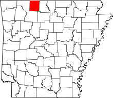 | |
| Towns | ||
| Townships | ||
| Unincorporated communities | ||
| Ghost town | ||
| Footnotes | ‡This populated place also has portions in an adjacent county or counties | |