Harrismith
| Harrismith | |
|---|---|
|
View from the north | |
 Harrismith  Harrismith  Harrismith
| |
| Coordinates: 28°17′0″S 29°08′0″E / 28.28333°S 29.13333°ECoordinates: 28°17′0″S 29°08′0″E / 28.28333°S 29.13333°E | |
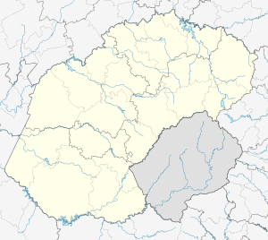
| Country | South Africa |
| Province | Free State |
| District | Thabo Mofutsanyane |
| Municipality | Maluti-a-Phofung |
| Established | 1849[1] |
| Area[2] | |
| • Total | 138.80 km2 (53.59 sq mi) |
| Population (2011)[2] | |
| • Total | 27,869 |
| • Density | 200/km2 (520/sq mi) |
| Racial makeup (2011)[2] | |
| • Black African | 87.1% |
| • Coloured | 0.8% |
| • Indian/Asian | 1.3% |
| • White | 10.7% |
| • Other | 0.2% |
| First languages (2011)[2] | |
| • Zulu | 49.4% |
| • Sotho | 32.6% |
| • Afrikaans | 10.4% |
| • English | 3.7% |
| • Other | 3.8% |
| Postal code (street) | 9880 |
| PO box | 9880 |
| Area code | 058 |
| Website | Harrismith - Community Website |

Harrismith, named after Sir Harry Smith who was a British governor of the Cape Colony,[3] is a town in the Free State province of South Africa. It is situated by the Wilge River, on the N3 highway approximately midway between Johannesburg, about 300 km north-west, and Durban. The town is at the junction with the N5 highway, which continues west towards the provincial capital Bloemfontein, around 340 km south-west. This important crossroads in South Africa's land trade routes is surrounded by mesas and buttes and located at base of one of these called Platberg ("Flat Mountain" translated from Afrikaans).
History
The town was founded in 1849 and named after British Governor Harry Smith, who tried to persuade the Voortrekkers not to abandon Natal.
The town was initially laid out by Robert Moffat about 25 km from the present location, in present-day Aberfeldy on the Elands River. This site unfortunately proved to be deficient in water and Harrismith was shifted to its present site in January 1850. Twenty-four years later it became a municipality and during the diamond rush at Kimberley, the town became a busy staging post on the Natal transport route. As a direct result of this, hotels, stores and public buildings sprang up. Harrismith was a major base during the South African (Anglo-Boer) War and visitors can see the several blockhouses, engineering works and a military cemetery that are evidence of this.
The town's main street, Warden Street, is named after Major Henry D. Warden, at that time a British resident in Bloemfontein.
The town is around 90 kilometers west from Ladysmith, a town named after Sir Harry Smith's wife that is located in the KwaZulu-Natal province. It is a similar distance east of Bethlehem
The small nearby hamlet of Swinburne is named after Sir Johan Swinburne, a gold prospector.
Present day
Harrismith is well known as a convenient refuelling stop for trucks, vehicles and people but it has much more to offer. Beyond the highway is a tidy town with many elegant late 19th century buildings made of hewn sandstone. There are numerous Bed & Breakfast places catering to visitors. Located near the scenic eastern escarpment border with KwaZulu-Natal Province, it is the best access point to the northernmost Drakensberg including Tugela Falls and Mont-Aux-Sources (accessed via the Sentinel Hiking Trail, in the Qwa-Qwa region of the Free State, 80 km South of Harrismith on the R57), Sterkfontein Dam Nature Reserve (20 km southeast of town on the R74), Royal Natal Park and the uKhahlamba / Drakensberg Park World Heritage Site (66 km southeast via Oliviershoek Pass beyond Sterkfontein Dam) and the spectacular Golden Gate Highlands National Park 50 km south of town on the R712.
Harrismith is the centre of one of the five wool producing districts in Southern Africa.
The town is also home to the largest truck stop in the Southern Hemisphere, Highway Junction.
Harrismith is also home to the small Harrismith Airport.
Two other places in the world bear the same name: Harrismith Beach and Harrismith House near Bottom Bay in Barbados and Harrismith in the Wheatbelt region of Western Australia.
Tourist attractions
- Harrismith Town Hall - A graceful sandstone and brick building built in 1907, and a National Monument.
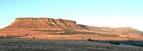
- Platberg Reserve - One of the most famous landmarks in the Eastern Free State is the 9 kilometre long, 2,394 metre high, Platberg. The reserve covers the western slopes and summit of the mountain, including the former Drakensberg Botanical Garden (founded as a national botanical garden in 1967 but unfortunately now defunct), along with numerous trails and the Donkey Pass road to the mountain summit. The reserve is popular with hikers and mountain bike riders. The two dams in the former wildflower gardens are part of a series of aqueducts, flowing from the Gibson Dam on the mountain summit, that were built as a water supply to support the town and the British troops stationed here after the South African War. A well-preserved sandstone blockhouse from that time guards over this water supply. Much of the southern slopes of the mountain are covered in Eucalypt, Wattle, and other exotic timber plantations from the time when a forestry centre was based here. Akkerbos, near the base of Donkey Pass, is a grove of oak trees that provided a picnic site during a Royal Tour by the British monarchy, including Elizabeth II in 1947. The reserve is home to herds of Eland, Black wildebeest, Blesbok and Mountain reedbuck along with introduced species such as Waterbuck and Fallow deer.
- The annual Platberg Mountain Race is a 15 km foot race, that includes a scrambling ascent and descent of the mountain. This race forms part of the Berg Bohaai festival (literally "Mountain Mania" in Afrikaans). The race has been described as the "toughest marathon in the world" by Wally Hayward. It originated in 1922 when a British soldier, Major A. E. Belcher, returned to Harrismith where he had been stationed near 42nd Hill during the Second Boer War. He referred to Platberg as "that small hill of yours", and one of the locals immediately bet him that he could not reach the top in less than 60 minutes. He accepted the challenge and covered the distance with eight minutes to spare. Afterwards Major Belcher presented a floating trophy to be awarded as a prize for the first athlete to reach the top of the mountain (the record time today is 22 minutes and 9 seconds). The 15 kilometre race starts from the town's sports grounds, and the route ascends the slopes of Platberg, passing through the terrain where the concentration camp once stood. The top is reached via One Man's Pass, close to which a fort, built during the Second Boer War, is to be seen. After traversing a short stretch along the top, the descent is made via Zig-Zag Pass, and the race is completed at the sports grounds.[4]
- Harrismith Golf Course - The scenic 18-hole golf course, arguably the third oldest in South Africa (after the Royal Cape and George Golf Clubs) was founded in 1887.
- Dirty Harry - The Dirty Harry is a mountain bike race sponsored by the N3 Toll Company. The Dirty Harry also forms part of the popular Berg Bohaai festival. This festival is held annually in early October.

- Kerkenberg - The Voortrekkers camped in the area, while their leader, Piet Retief, descended into KwaZulu-Natal to negotiate for land with the Zulu chief Dingane. Retief's daughter wrote his name and recorded the date, which was also his birthday, on the rock where they held a church service.
- Sterkfontein Dam - The third largest dam in South Africa. Practically all the water is pumped up the escarpment from KwaZulu-Natal. Built before the Lesotho Highlands Water Project was developed, this was a vital source of water for Gauteng. Ideal for water sport enthusiasts and anglers. Sterkfontein Dam is particularly popular with windsurfers.
- Bushmen Paintings - Around 5 kilometers out of town in one of local caves well-preserved Bushmen paintings can still be found.
- Neo Paintings - Around 5 km from town, this Sotho king painted in caves close to the Sterkfontein Dam.
Coats of arms
Municipal (1)
By 1931, the Harrismith municipal council had assumed a pseudo-heraldic coat of arms.[5] The shield was divided by a horizontal line, the upper half depicting three upright maize cobs and three sheaves of wheat on a silver background, and the lower half a cornucopia. The crest was a plough, and the motto Grandescunt aucta labore.
Municipal (2)
A proper coat of arms was designed (by Schalk Pienaar) in the 1970s, and registered at the Bureau of Heraldry in September 1977.[6]
The arms were : Argent, a chevron Azure between in chief an elephant statant proper and in base a demi-cogwheel issuant Gules, two flaunches Vert each charged with an ear of wheat, Or. In layman's terms, the shield is silver and depicts, from top to bottom, an elephant, a blue chevron, and the upper half of a red cogwheel, and on each side is a curved green segment bearing a golden ear of wheat.
Once again, the crest was a plough and the motto was Grandescunt aucta labore.
References
- ↑ "Chronological order of town establishment in South Africa based on Floyd (1960:20-26)" (PDF). pp. xlv–lii.
- 1 2 3 4 "Main Place Harrismith". Census 2011.
- ↑ "Sir Harry Smith - An autobiography showing him to have seen warfare in four continents." (PDF). The New York Times. 1902-05-24. Retrieved 2008-10-21.
- ↑ "Harrismith Mountain Race". Harrismith Mountain Race. Retrieved 2011-03-10.
- ↑ The arms were depicted on a cigarette card issued in 1931.
- ↑ http://www.national.archsrch.gov.za
| Wikimedia Commons has media related to Harrismith. |
Municipalities and communities of Thabo Mofutsanyana District Municipality, Free State | ||
|---|---|---|
District seat: Phuthaditjhaba (Witsieshoek) | ||
| Setsoto | .svg.png) | |
| Dihlabeng | ||
| Nketoana | ||
| Maluti-a-Phofung | ||
| Phumelela | ||
| Mantsopa | ||