Harden Shire
| Harden Shire New South Wales | |||||||||||||
|---|---|---|---|---|---|---|---|---|---|---|---|---|---|
 Location in New South Wales | |||||||||||||
| Coordinates | 34°33′S 148°22′E / 34.550°S 148.367°ECoordinates: 34°33′S 148°22′E / 34.550°S 148.367°E | ||||||||||||
| Population | 3,584 (2011 census)[1] | ||||||||||||
| • Density | 1.9176/km2 (4.9666/sq mi) | ||||||||||||
| Established | 1 January 1975 | ||||||||||||
| Abolished | 12 May 2016 | ||||||||||||
| Area | 1,869 km2 (721.6 sq mi)[2] | ||||||||||||
| Mayor | John Horton | ||||||||||||
| Council seat | Harden[2] | ||||||||||||
| Region | South West Slopes | ||||||||||||
| State electorate(s) | Cootamundra | ||||||||||||
| Federal Division(s) | Hume | ||||||||||||
| Website | Harden Shire | ||||||||||||
| |||||||||||||
Harden Shire was a local government area in the South West Slopes region of New South Wales, Australia. The Shire included the twin towns of Harden and Murrumburrah and the small towns of Galong, Jugiong, Wombat and Kingsvale.
The Shire was established in 1975 from the merger of the Municipality of Murrumburrah with Demondrille Shire.[3] In 2016, Harden Shire was amalgamated with Boorowa Shire and Young Shire to create Hilltops Council.[4]
The last Mayor of Harden Shire was Cr. John Horton, an unaligned politician.
Council
Composition and election method
Harden Shire Council was composed of seven Councillors elected proportionally as one entire ward. All Councillors were elected for a fixed four-year term of office. The Mayor was elected by the Councillors at the first meeting of the Council. The last democratic election was held on 8 September 2012, and the makeup of the Council was as follows:[5]
| Party | Councillors | |
|---|---|---|
| Independents and Unaligned | 7 | |
| Total | 7 | |
The final Council, elected in 2012 and dissolved in 2016, in order of election, was:[5]
| Councillor | Party | Notes | |
|---|---|---|---|
| Chris Manchester | Unaligned | Mayor[6] | |
| Matthew Stadtmiller | Independent Deputy Mayor | ||
| John Horton | Unaligned | ||
| Tony Flanery | Unaligned | ||
| Cathy Sanderson | Unaligned | ||
| Neil Reid | Unaligned | [6] | |
| Tony Campbell | Unaligned | ||
Amalgamation
A 2015 review of local government boundaries recommended that Harden Shire merge with adjoining councils. The NSW Government considered two proposals. The first proposed a merger between the Harden, Boorowa and Young shires to form a new council with an area of 7,139 square kilometres (2,756 sq mi) and support a population of approximately 19,000.[7] The alternative, proposed by Harden Shire on 28 February 2016, was for an amalgamation of the Cootamundra, Gundagai and Harden shires.[8] Following an independent review, on 12 May 2016, the Minister for Local Government announced the dissolution of the Boorowa, Harden and Young shires and merged the areas to form the Hilltops Council with immediate effect.[4]
Gallery
-
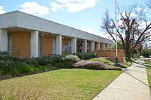
The former Harden Shire Council office
-
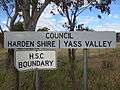
A former shire boundary sign (circa 2015)
References
- ↑ Australian Bureau of Statistics (31 October 2012). "Harden Shire". 2011 Census QuickStats. Retrieved 3 April 2015.
- 1 2 "Harden Shire Council". Department of Local Government. Retrieved 7 November 2006.
- ↑ "Murrumburrah Municipal Council Council". Search. State Records NSW. Retrieved 21 May 2016.
- 1 2 "Hilltops Council". Stronger Councils. Government of New South Wales. 12 May 2016. Retrieved 14 May 2016.
- 1 2 "Harden Shire Council: Summary of First Preference Votes for each Candidate". Local Government Elections 2012. Electoral Commission of New South Wales. 14 September 2012. Retrieved 7 October 2012.
- 1 2 "Grant to investigate raising houses at Jugiong". ABC News. Australia. 20 September 2012. Retrieved 7 October 2012.
- ↑ "Merger proposal: Boorowa Council, Harden Shire Council, Young Shire Council" (PDF). Government of New South Wales. January 2016. p. 7. Retrieved 8 March 2016.
- ↑ Harden Shire Council (28 February 2016). "Fit For Future: Alternate Merger Proposal - Harden Shire Council" (PDF). Government of New South Wales. Retrieved 8 March 2016.