Hardbrücke
| Hardbrücke | |
|---|---|
|
Hardbrücke bridge and railway station | |
| Coordinates | 47°23′07″N 8°31′02″E / 47.38514°N 8.51717°ECoordinates: 47°23′07″N 8°31′02″E / 47.38514°N 8.51717°E |
| Crosses |
River Limmat Zürich–Olten railway line Various streets |
| Locale |
City of Zürich, Canton of Zürich, Switzerland |
| Characteristics | |
| Design | Girder bridge |
| Total length | 1,350 m (4,430 ft) |
| Width | 17.5 m (57 ft) to 28.4 m (93 ft) |
| History | |
| Construction begin | 1969 |
| Opened | 1972 |

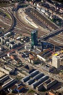
The Hardbrücke is a road bridge and important north-south connection in the Swiss city of Zürich. The bridge is 1,350 metres (4,430 ft) long, and crosses the River Limmat, the Zürich to Olten railway line, and several streets. In crossing the river, the Hardbrücke forms an upper level to the lower level Wipkingerbrücke road bridge. Between the river and rail crossings, several exit and entrance ramps link the bridge to the streets below.
Construction of the bridge commenced in 1969 and it was opened in 1972. The bridge underwent a major refurbishment between 2009 and 2011.
At the point at which the bridge crosses the railway tracks, it provides access to Zürich Hardbrücke railway station on the Zürich S-Bahn. Zürich trolleybus routes 33 and 72 cross the bridge, serving stops adjacent to the railway station. There are plans to extend the Zürich tram system across the Hardbrücke between Hardplatz and Schiffbau.[1][2][3]
Gallery
|


References
- ↑ Eisenbahnatlas Schweiz. Verlag Schweers + Wall GmbH. 2012. pp. 64–65. ISBN 978-3-89494-130-7.
- ↑ "S-Bahn trains, buses and boats" (PDF). ZVV. Retrieved 2013-04-01.
- ↑ Moglestue, Andrew (March 2013). "City council approves Hardbrücke tram". Retrieved 2013-03-22.
External links
-
 Media related to Hardbrücke at Wikimedia Commons