Hardanger Bridge
| Hardanger Bridge Hardangerbrua | |
|---|---|
 View of the bridge seen from the east | |
| Coordinates | 60°28′46″N 6°49′53″E / 60.47944°N 6.83139°ECoordinates: 60°28′46″N 6°49′53″E / 60.47944°N 6.83139°E |
| Carries | 713 |
| Crosses | Hardangerfjorden |
| Locale | Ullensvang and Ulvik, Hordaland |
| Maintained by | Norwegian Public Roads Administration[1] |
| Characteristics | |
| Design | Suspension bridge |
| Total length | 1,400 metres (4,600 ft)[2] |
| Width | 20 metres (66 ft)[2] |
| Height | 200 metres (660 ft)[2] |
| Longest span | 1,310 metres (4,300 ft)[2] |
| Clearance below | 55 metres (180 ft)[2] |
| History | |
| Constructed by | MT Højgaard[2] |
| Construction begin | February 2009 |
| Construction end | August 2013 |
| Statistics | |
| Toll | Yes |
Hardanger Bridge (Norwegian: Hardangerbrua) is a suspension bridge across the Eidfjorden branch of Hardangerfjorden in Hordaland county, Norway. The bridge connects the municipalities of Ullensvang and Ulvik. It replaced a ferry connection between Bruravik and Brimnes, and thereby shortens the driving time between Oslo and Bergen. It is the longest suspension bridge in Norway.[3]
Construction
The bridge was approved for building by the Norwegian Parliament on February 28, 2006, and construction began on February 26, 2009.[1] While the bridge was engineered by the Norwegian Public Roads Administration, the construction is done by MT Højgaard.[2] The project had a budget of NOK 2.3 billion (€290 million) and more than half of this will be paid by toll and saved ferry subsidies.[4] The Administration is considering a different route over a future bridge as the main connection between East and West.[5]

The ferry, serviced by Fjord1, ran across the fjord every 20–60 minutes depending on the season, and the trip lasted 10 minutes.
The bridge is 1,400 metres (4,600 ft) long, with a main span of 1,310 metres (4,300 ft). Sailing height is 55 metres (180 ft) and the towers reach 200 metres (660 ft) above sea level. There are two driving lanes for cars with an 80 kilometres per hour (50 mph) speed limit, and a separate lane for pedestrians and cyclists.[6] The sailing height means that the largest cruise ships can't reach the inner Hardangerfjord anymore.
The traffic predicted for the bridge was only estimated to be 2000 vehicles per day.[6] The opening of the bridge took place on 17 August 2013.
The main span is one of the longest suspension bridge spans in the world.[7] It is also the longest tunnel to tunnel suspension bridge in the world. On the south end of the bridge, cars immediately enter the 1.2-kilometre (0.75 mi) Bu Tunnel that goes under the village of Bu and on the north side of the bridge, cars immediately enter the 7.5-kilometre (4.7 mi) Vallavik Tunnel which includes a 500-metre (1,600 ft) long segment to a roundabout inside the tunnel. At the roundabout, cars can take another 500-metre (1,600 ft) long tunnel that leads to Ulvik or they can take a 7-kilometre (4.3 mi) long tunnel to Granvin.
Media gallery
 The bridge under construction, July 2010
 Tower Cable Saddles for Hardanger Bridge
 The bridge towers under construction
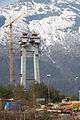 Construction of the bridge
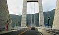 View while crossing
 View looking up while crossing
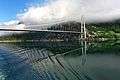 View from a passing boat
References
- 1 2 "The Hardanger Bridge". Statens vegvesen. Retrieved July 9, 2013.
- 1 2 3 4 5 6 7 Hardanger Bridge at Structurae. Retrieved on 2014-05-25.
- ↑ Merzagora, Eugenio A. (ed.). "Road Viaducts & Bridges in Norway (> 500 m)". Norske bruer og viadukter. Retrieved 2014-05-25.
- ↑ "Finance". Statens vegvesen. Retrieved July 9, 2013.
- ↑ Nikolaisen, Per-Ivar . "Hardangerbrua åpnet for 18 måneder siden. Nå vil Vegvesenet bygge ny" Teknisk Ukeblad, 22 January 2015. Accessed: 22 January 2015.
- 1 2 "Technical facts". Statens vegvesen. Retrieved July 9, 2013.
- ↑ Hardanger Bridge – Information. Statens vegvesen. 2011. p. 7.
External links
| Wikimedia Commons has media related to Hardangerbridge. |
- Official home page
- Technical specifications brochure (PDF)
- Hardangerbrua nytt reisemål [The Hardanger Bridge, new travel destination]