Kfar Hasidim
| Kfar Hasidim | |
|---|---|
 | |
 Kfar Hasidim | |
| Coordinates: 32°44′35.52″N 35°5′36.59″E / 32.7432000°N 35.0934972°ECoordinates: 32°44′35.52″N 35°5′36.59″E / 32.7432000°N 35.0934972°E | |
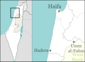
| District | Haifa |
| Council | Zevulun |
| Founded | 1924 |
| Founded by | Polish immigrants |
| Population (2015)[1] | 798 |
Kfar Hasidim (Hebrew: כְּפַר חֲסִידִים, lit. Village of Hasidim), also known as Kfar Hasidim Alef to distinguish it from Kfar Hasidim Bet, is a moshav in northern Israel. Located near Kiryat Ata, it falls under the jurisdiction of Zevulun Regional Council. In 2015 it had a population of 798.
History
Ottoman era
During the Ottoman era was here a Muslim village called Harbaj.[2] In 1162 A.H (~1748 CE) it was fortified by Zahir al-Umar, and traces of the wall still existed in the late 19th century.[3] The village appeared as El Harchieh on the map that Pierre Jacotin compiled in 1799.[4]
In 1875, Victor Guérin found here about 30 houses, still inhabited. In the centre of the village was a large well, partly filled.[5] In 1881, the Palestine Exploration Fund's Survey of Western Palestine described El Harbaj as “a small adobe village, on the plain, with a well to the north and olives to the east.”[3]
British Mandate era
In the 1922 census of Palestine conducted by the British Mandate authorities, Harbaj had a population 177, all Muslims.[6]
Kfar Hasidim was founded in 1924 by a group of Hasidic immigrants of the Fourth Aliyah who had been preparing in Poland. Although the Hasidic town of Bnei Brak had already been established, this time the aim was to create an agricultural settlement rather than an urban one.
In 1925 a Zionist organisation purchased 70 feddans in Harbaj from Alexander Sursuk, of the Sursuk family of Beirut. At the time, there were 50 families living there.[7] From 1931, and lasting several years, the Jewish Agency struggled to evict the tenant farmers from Harbaj, from the land which was to become Kfar Hasidim.[8]
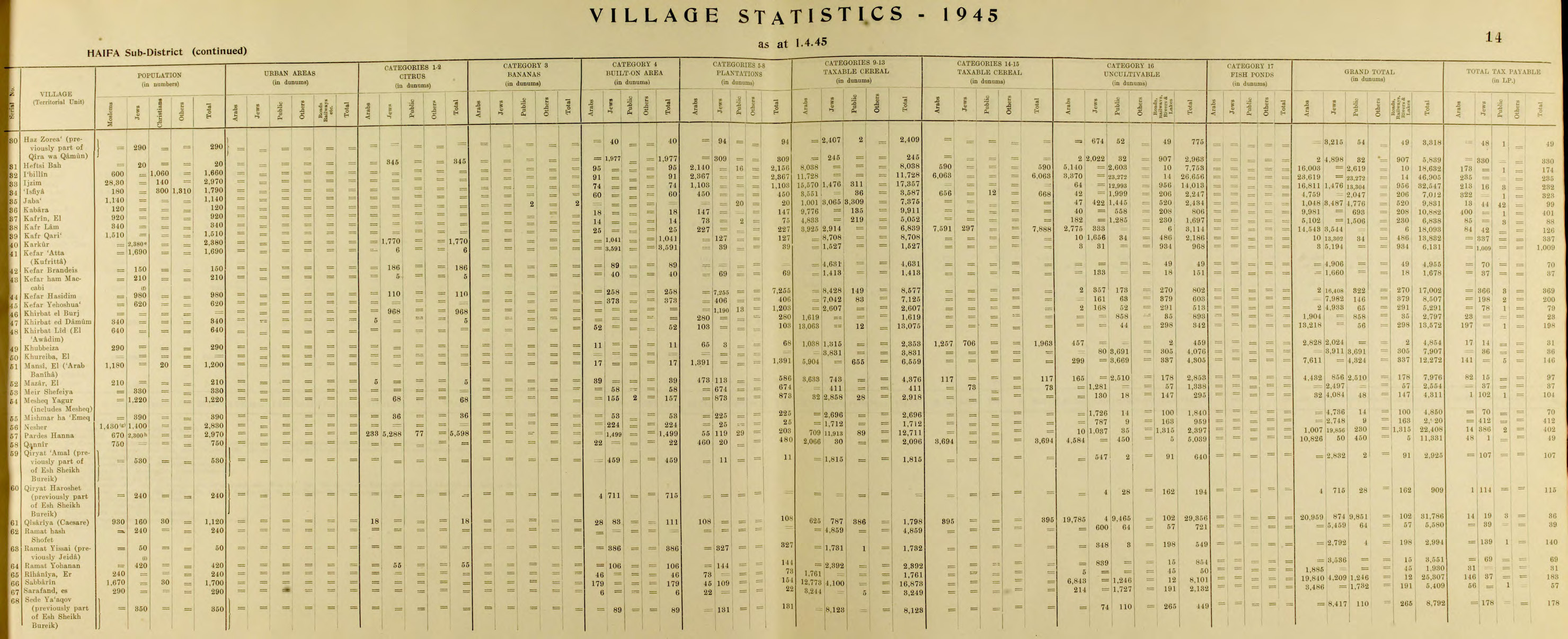
In the 1931 census Kefir Hassidim had a population of 420, all Jews, in a total of 104 houses.[9] By 1945, Kfar Hasidim had 980 residents, all Jewish.[10][11]

State of Israel
Shlomo Goren, future head of the Military Rabbinate of the Israel Defense Forces and subsequently Ashkenazi Chief Rabbi of Israel from 1973 to 1983, was raised in Kfar Hasidim, which his father co-founded.
In 1950 Kfar Hasidim Bet was established nearby by non-agricultural residents of Kfar Hasidim. Today the village is largely national-religious and secular. The Kfar HaNoar HaDati youth village lies adjacent to the moshav.
References
- ↑ "List of localities, in Alphabetical order" (PDF). Israel Central Bureau of Statistics. Retrieved 16 October 2016.
- ↑ from a personal name, Palmer, 1881, p. 109
- 1 2 Conder and Kitchener, 1881, SWP I, p. 285
- ↑ Karmon, 1960, p. 162
- ↑ Guérin, 1880, p. 401
- ↑ Barron, 1923, Table XI, Sub-district of Haifa, p. 33
- ↑ List of villages sold by Sursocks and their partners to the Zionists since British occupation of Palestine, evidence to the Shaw Commission, 1930
- ↑ Avneri, 1984, pp. 156-7
- ↑ Mills, 1932, p. 98
- ↑ Department of Statistics, 1945, p. 14
- ↑ Government of Palestine, Department of Statistics. Village Statistics, April, 1945. Quoted in Hadawi, 1970, p. 48
Bibliography
| Wikimedia Commons has media related to Kfar Hasidim. |
- Avneri, Arieh L. (1984). The Claim of Dispossession: Jewish Land-settlement and the Arabs, 1878-1948. Transaction Publishers. ISBN 0-87855-964-7.
- Barron, J. B., ed. (1923). Palestine: Report and General Abstracts of the Census of 1922. Government of Palestine.
- Conder, Claude Reignier; Kitchener, H. H. (1882). The Survey of Western Palestine: Memoirs of the Topography, Orography, Hydrography, and Archaeology. 2. London: Committee of the Palestine Exploration Fund.
- Department of Statistics (1945). Village Statistics, April, 1945. Government of Palestine.
- Guérin, Victor (1880). Description Géographique Historique et Archéologique de la Palestine (in French). 3: Galilee, pt. 1. Paris: L'Imprimerie Nationale.
- Hadawi, Sami (1970). Village Statistics of 1945: A Classification of Land and Area ownership in Palestine. Palestine Liberation Organization Research Center.
- Karmon, Y. (1960). "An Analysis of Jacotin's Map of Palestine" (PDF). Israel Exploration Journal. 10 (3,4): 155–173; 244–253.
- Mills, E., ed. (1932). Census of Palestine 1931. Population of Villages, Towns and Administrative Areas. Jerusalem: Government of Palestine.
- Palmer, E. H. (1881). The Survey of Western Palestine: Arabic and English Name Lists Collected During the Survey by Lieutenants Conder and Kitchener, R. E. Transliterated and Explained by E.H. Palmer. Committee of the Palestine Exploration Fund.
External links
- Survey of Western Palestine, Map 5: IAA, Wikimedia commons