Haralson County, Georgia
| Haralson County, Georgia | |
|---|---|
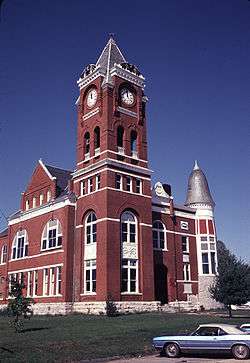 Former Haralson County Courthouse in Buchanan | |
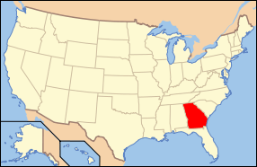
 Location in the U.S. state of Georgia | |
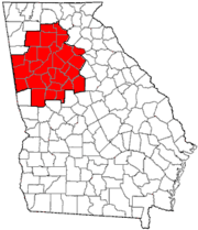
 Georgia's location in the U.S. | |
| Founded | January 26, 1856 |
| Named for | Hugh A. Haralson |
| Seat | Buchanan |
| Largest city | Bremen |
| Area | |
| • Total | 283 sq mi (733 km2) |
| • Land | 282 sq mi (730 km2) |
| • Water | 1.0 sq mi (3 km2), 0.4% |
| Population | |
| • (2010) | 28,780 |
| • Density | 102/sq mi (39/km²) |
| Congressional district | 14th |
| Time zone | Eastern: UTC-5/-4 |
Haralson County is a county located in the northwestern part of the U.S. state of Georgia. As of the 2010 census, the population was 28,780.[1] The county seat is Buchanan.[2] The county was created on January 26, 1856 and was named for Hugh A. Haralson, a former Georgia congressman.[3][4]
Haralson County is part of the Atlanta-Sandy Springs-Roswell, GA Metropolitan Statistical Area.
Law/Government
The county was originally governed by a sole Commissioner of Roads and Revenues. The last occupant of this office was Charles Sanders (D). The county is now governed by a five-member Board of Commissioners, which replaced the single-commissioner form beginning with the term starting in January 2005. The Chairman of the Board is elected county-wide. The current occupant of this office is Allen Poole (R), who had previously come close to winning election in the single-commissioner era. There are four other commissioners, one elected from each of four geographical districts. The current occupants of these offices are District 1's Kenneth Smith(R), District 2's Jamie Brown Bennett (R), District 3's John Dobbs(D) and District 4's Sammy Robinson (D). The current sheriff of Haralson County is Eddie Mixon. Judge J. Edward "Eddie" Hulsey, Jr. is the current probate judge.
Geography
According to the U.S. Census Bureau, the county has a total area of 283 square miles (730 km2), of which 282 square miles (730 km2) is land and 1.0 square mile (2.6 km2) (0.4%) is water.[5]
The vast majority of Haralson County is located in the Upper Tallapoosa River sub-basin of the ACT River Basin (Coosa-Tallapoosa River Basin). Just the very northwestern corner of the county is located in the Upper Coosa River sub-basin of the same ACT River Basin.[6]
Major highways
Adjacent counties
- Polk County - north
- Paulding County - northeast
- Carroll County - south
- Cleburne County, Alabama - west (CST)
Demographics
| Historical population | |||
|---|---|---|---|
| Census | Pop. | %± | |
| 1860 | 3,039 | — | |
| 1870 | 4,004 | 31.8% | |
| 1880 | 5,972 | 49.2% | |
| 1890 | 11,316 | 89.5% | |
| 1900 | 11,922 | 5.4% | |
| 1910 | 13,514 | 13.4% | |
| 1920 | 14,440 | 6.9% | |
| 1930 | 13,263 | −8.2% | |
| 1940 | 14,377 | 8.4% | |
| 1950 | 14,663 | 2.0% | |
| 1960 | 14,543 | −0.8% | |
| 1970 | 15,927 | 9.5% | |
| 1980 | 18,422 | 15.7% | |
| 1990 | 21,966 | 19.2% | |
| 2000 | 25,690 | 17.0% | |
| 2010 | 28,780 | 12.0% | |
| Est. 2015 | 28,854 | [7] | 0.3% |
| U.S. Decennial Census[8] 1790-1960[9] 1900-1990[10] 1990-2000[11] 2010-2013[1] | |||
2000 census
As of the census[12] of 2000, there were 25,690 people, 9,826 households, and 7,192 families residing in the county. The population density was 91 people per square mile (35/km²). There were 10,719 housing units at an average density of 38 per square mile (15/km²). The racial makeup of the county was 92.97% White, 5.40% Black or African American, 0.25% Native American, 0.34% Asian, 0.20% from other races, and 0.83% from two or more races. 0.56% of the population were Hispanic or Latino of any race.
There were 9,826 households out of which 33.50% had children under the age of 18 living with them, 57.70% were married couples living together, 11.30% had a female householder with no husband present, and 26.80% were non-families. 23.00% of all households were made up of individuals and 10.20% had someone living alone who was 65 years of age or older. The average household size was 2.58 and the average family size was 3.03.
In the county the population was spread out with 26.10% under the age of 18, 8.10% from 18 to 24, 29.20% from 25 to 44, 23.60% from 45 to 64, and 13.00% who were 65 years of age or older. The median age was 36 years. For every 100 females there were 95.20 males. For every 100 females age 18 and over, there were 91.20 males.
The median income for a household in the county was $31,656, and the median income for a family was $38,373. Males had a median income of $31,816 versus $20,821 for females. The per capita income for the county was $15,823. About 11.40% of families and 15.50% of the population were below the poverty line, including 18.10% of those under age 18 and 16.10% of those age 65 or over.
2010 census
As of the 2010 United States Census, there were 28,780 people, 10,757 households, and 7,820 families residing in the county.[13] The population density was 102.0 inhabitants per square mile (39.4/km2). There were 12,287 housing units at an average density of 43.5 per square mile (16.8/km2).[14] The racial makeup of the county was 92.8% white, 4.7% black or African American, 0.5% Asian, 0.2% American Indian, 0.4% from other races, and 1.4% from two or more races. Those of Hispanic or Latino origin made up 1.1% of the population.[13] In terms of ancestry, 37.1% were American, 14.1% were Irish, 11.1% were English, and 6.0% were German.[15]
Of the 10,757 households, 36.6% had children under the age of 18 living with them, 53.8% were married couples living together, 13.3% had a female householder with no husband present, 27.3% were non-families, and 23.2% of all households were made up of individuals. The average household size was 2.64 and the average family size was 3.09. The median age was 38.5 years.[13]
The median income for a household in the county was $38,996 and the median income for a family was $45,339. Males had a median income of $39,452 versus $32,170 for females. The per capita income for the county was $19,033. About 15.6% of families and 20.4% of the population were below the poverty line, including 28.8% of those under age 18 and 16.4% of those age 65 or over.[16]
Education
Public education in the county is largely provided by the Haralson County School District. However, the City of Bremen, which straddles the border of Haralson and Carroll Counties, operates the independent Bremen City School District.
Communities
See also
References
- 1 2 "State & County QuickFacts". United States Census Bureau. Retrieved February 16, 2014.
- ↑ "Find a County". National Association of Counties. Retrieved 2011-06-07.
- ↑
- ↑ Gannett, Henry (1905). The Origin of Certain Place Names in the United States. Govt. Print. Off. p. 149.
- ↑ "US Gazetteer files: 2010, 2000, and 1990". United States Census Bureau. 2011-02-12. Retrieved 2011-04-23.
- ↑ "Georgia Soil and Water Conservation Commission Interactive Mapping Experience". Georgia Soil and Water Conservation Commission. Retrieved 2015-11-19.
- ↑ "County Totals Dataset: Population, Population Change and Estimated Components of Population Change: April 1, 2010 to July 1, 2015". Retrieved July 2, 2016.
- ↑ "U.S. Decennial Census". United States Census Bureau. Retrieved June 23, 2014.
- ↑ "Historical Census Browser". University of Virginia Library. Retrieved June 23, 2014.
- ↑ "Population of Counties by Decennial Census: 1900 to 1990". United States Census Bureau. Retrieved June 23, 2014.
- ↑ "Census 2000 PHC-T-4. Ranking Tables for Counties: 1990 and 2000" (PDF). United States Census Bureau. Retrieved June 23, 2014.
- ↑ "American FactFinder". United States Census Bureau. Retrieved 2011-05-14.
- 1 2 3 "DP-1 Profile of General Population and Housing Characteristics: 2010 Demographic Profile Data". United States Census Bureau. Retrieved 2015-12-29.
- ↑ "Population, Housing Units, Area, and Density: 2010 - County". United States Census Bureau. Retrieved 2015-12-29.
- ↑ "DP02 SELECTED SOCIAL CHARACTERISTICS IN THE UNITED STATES – 2006-2010 American Community Survey 5-Year Estimates". United States Census Bureau. Retrieved 2015-12-29.
- ↑ "DP03 SELECTED ECONOMIC CHARACTERISTICS – 2006-2010 American Community Survey 5-Year Estimates". United States Census Bureau. Retrieved 2015-12-29.
External links
- Haralson County Historical Society
- Haralson County Chamber of Commerce
- Haralson County Development Authority
- Haralson County historical marker
 |
Polk County | Paulding County | | |
| Cleburne County, Alabama | |
|||
| ||||
| | ||||
| Carroll County |
Municipalities and communities of Haralson County, Georgia, United States | ||
|---|---|---|
| Cities | | |
| Unincorporated communities | ||
| Footnotes | ‡This populated place also has portions in an adjacent county or counties | |
|  | |||||||
|
| ||||||||
| ||||||||
Template:Georgia
Coordinates: 33°47′N 85°13′W / 33.79°N 85.21°W