Hanover County, Virginia
| Hanover County, Virginia | ||
|---|---|---|
|
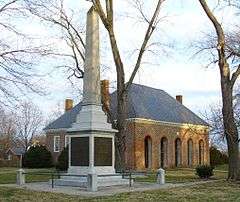
Current Hanover County Courthouse | ||
| ||
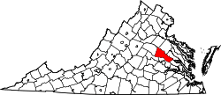 Location in the U.S. state of Virginia | ||
 Virginia's location in the U.S. | ||
| Founded | 1720 | |
| Named for | Electorate of Hanover | |
| Seat | Hanover Courthouse | |
| Largest town | Ashland | |
| Area | ||
| • Total | 474 sq mi (1,228 km2) | |
| • Land | 469 sq mi (1,215 km2) | |
| • Water | 5 sq mi (13 km2), 1.1% | |
| Population | ||
| • (2010) | 99,863 | |
| • Density | 213/sq mi (82.2/km²) | |
| Congressional district | 7th | |
| Time zone | Eastern: UTC-5/-4 | |
| Website |
www | |


Hanover County is located in the Commonwealth of Virginia. As of the 2010 census, the population was 99,863.[1] Its county seat is Hanover Courthouse.[2]
Hanover County is included in the Greater Richmond Region.
History

Located in the Piedmont of Virginia, Hanover County was created on November 26, 1719, from the area of New Kent County called St. Paul's Parish. It was named for the Electorate of Hanover in Germany, because King George I of Great Britain was Elector of Hanover at the time. The county was developed by planters moving west from the Virginia tidewater, where soils had been exhausted by tobacco monoculture.
Hanover County was the birthplace and home of noted American statesman Patrick Henry. He reportedly married Sarah Shelton in the parlor of her family's house, Rural Plains, also known as Shelton House. At the Hanover Courthouse, Henry argued the case of the Parson's Cause in 1763, attacking the British Crown's attempt to set the salaries of clergy in the colony regardless of conditions in the local economy. The historic Hanover Courthouse is pictured in the county seal. Hanover County was also the birthplace of Henry Clay, who became known as a politician in Kentucky, author of the Missouri Compromise of 1820, and Secretary of State.
At one point, Hanover County is only 5 miles (8.0 km) from the current city limits of Richmond. The Chickahominy River forms the border of the county in the Mechanicsville area. During the American Civil War and the 1862 Peninsula Campaign, the Union Army approached the river and could hear the bells of Richmond's churches. But they learned that the river was a major obstacle. Union General George B. McClellan failed in his attempt to get all his troops across it, intending to overwhelm the outnumbered Confederate forces defending Richmond. His failure to take Richmond, the Confederate capital, has been said to have prolonged the war by almost 3 years. Hanover County was the site of a number of Civil War battles, including the Seven Days Battles of the Peninsula Campaign and Battle of Cold Harbor in 1864.[3]
The incorporated town of Ashland is located within Hanover County. Ashland is the second and current home of Randolph-Macon College.
In 1953, Barksdale Theatre was founded at the historic Hanover Tavern. It was the nation's first dinner theater and central Virginia's first professional theatre organization.[4] The Barksdale company continues to produce live theatre at the Tavern, as well as at several locations in Richmond. It is recognized today as Central Virginia's leading professional theatre.
Kings Dominion amusement park opened in 1975 in Doswell and added to the county's economy. In January 2007, America's Promise named Hanover County as one of the top 100 communities for youth.
Geography
According to the U.S. Census Bureau, the county has a total area of 474 square miles (1,230 km2), of which 469 square miles (1,210 km2) is land and 5 square miles (13 km2) (1.1%) is water.[5]
Hanover County is about 90 miles (140 km) south of Washington, D.C., and about 12 miles (19 km) north of Richmond, Virginia.[6]
Adjacent counties
- Caroline County (north)
- Goochland County (southwest)
- Henrico County (south)
- King William County (northeast)
- Louisa County (west)
- New Kent County (east)
- Spotsylvania County (northwest)
Major highways
Demographics
| Historical population | |||
|---|---|---|---|
| Census | Pop. | %± | |
| 1790 | 14,754 | — | |
| 1800 | 14,403 | −2.4% | |
| 1810 | 15,082 | 4.7% | |
| 1820 | 15,267 | 1.2% | |
| 1830 | 16,253 | 6.5% | |
| 1840 | 14,968 | −7.9% | |
| 1850 | 15,153 | 1.2% | |
| 1860 | 17,222 | 13.7% | |
| 1870 | 16,455 | −4.5% | |
| 1880 | 18,588 | 13.0% | |
| 1890 | 17,402 | −6.4% | |
| 1900 | 17,618 | 1.2% | |
| 1910 | 17,200 | −2.4% | |
| 1920 | 18,088 | 5.2% | |
| 1930 | 17,009 | −6.0% | |
| 1940 | 18,500 | 8.8% | |
| 1950 | 21,985 | 18.8% | |
| 1960 | 27,550 | 25.3% | |
| 1970 | 37,479 | 36.0% | |
| 1980 | 50,398 | 34.5% | |
| 1990 | 63,306 | 25.6% | |
| 2000 | 86,320 | 36.4% | |
| 2010 | 99,863 | 15.7% | |
| Est. 2015 | 103,227 | [7] | 3.4% |
| U.S. Decennial Census[8] 1790-1960[9] 1900-1990[10] 1990-2000[11] 2010-2012[1] | |||
As of the 2010 United States Census, there were 99,863 people residing in the county. 86.7% were White, 9.3% Black or African American, 1.4% Asian, 0.4% Native American, 0.8% of some other race and 1.5% of two or more races; 2.1% were Hispanic or Latino (of any race).
As of the census[12] of 2000, there were 86,320 people, 31,121 households, and 24,461 families residing in the county. The population density was 183 people per square mile (71/km²). There were 32,196 housing units at an average density of 68 per square mile (26/km²). The racial makeup of the county was 88.32% White, 9.34% Black or African American, 0.33% Native American, 0.79% Asian, 0.01% Pacific Islander, 0.37% from other races, and 0.83% from two or more races. 0.98% of the population were Hispanic or Latino of any race.
There were 31,121 households out of which 39.50% had children under the age of 18 living with them, 66.40% were married couples living together, 9.30% had a female householder with no husband present, and 21.40% were non-families; 17.70% of all households were made up of individuals, and 6.80% had someone living alone who was 65 years of age or older. The average household size was 2.71, and the average family size was 3.07.
In the county, the population was spread out with 27.10% under the age of 18, 6.90% from 18 to 24, 30.70% from 25 to 44, 24.80% from 45 to 64, and 10.60% who were 65 years of age or older. The median age was 37 years. For every 100 females there were 96.90 males; for every 100 females age 18 and over, there were 92.80 males.
The median income for a household in the county was $59,223, and the median income for a family was $65,809. The median income was $42,523 for males and $30,689 for females. The per capita income for the county was $25,120. About 2.50% of families and 3.60% of the population were below the poverty line, including 3.90% of those under age 18 and 5.80% of those age 65 or over.
Government
Board of supervisors[13]
Ashland District: Faye O. Prichard (D)
Beaverdam District: Aubrey M. "Bucky" Stanley (R)
Chickahominy District: Angela C. Kelly-Wiecek (R)
Cold Harbor District: Scott A. Wyatt. (R)
Henry District: Sean M. Davis (R)
Mechanicsville District: W. Canova Peterson (R)
South Anna District: Wayne T. Hazzard (R)
Constitutional officers
Clerk of the Circuit Court: Frank D. Hargrove, Jr. (R)
Commissioner of the Revenue: T. Scott Harris (R)
Commonwealth's Attorney: R. E. "Trip" Chalkley, III (R)
Sheriff: David R. Hines (R)
Treasurer: M. Scott Miller (R)
Hanover is represented by Republicans Ryan T. McDougle and Siobhan Dunnavant and Democrat A. Donald McEachin in the Virginia Senate, Republican Buddy Fowler and Christopher K. Peace in the Virginia House of Delegates and Republican Dave Brat in the U.S. House of Representatives.
Education
Hanover County has fifteen elementary schools, four middle schools, four high schools, one alternative school, and one technology school. The four high schools are Atlee High School, Hanover High School, Lee-Davis High School, and Patrick Henry High School. Forbes magazine named Hanover County as one of the top fifty counties in the United States for student achievement vs. cost per student.
Economy
Hanover County has the lowest real estate property tax rate in the Richmond Region, which makes for a competitive business location.[14] Some of the major businesses that have taken advantage of the tax rate include: Bass Pro Shops, FedEx Ground, and The Vitamin Shoppe. These businesses located in the county with help from the Hanover County Economic Development and the Greater Richmond Partnership, regional economic development organizations.[15]
Top employers[16]
| Employer | Sector | Number of Employees |
|---|---|---|
| Hanover County | Government/Education | 1000+ |
| Bon Secours | Health Care | 1000+ |
| Kings Dominion | Amusement Park | 1000+ |
| Tyson Farms | Food Processing | 500-999 |
| SuperValu | Food Distributor | 500-999 |
| Randolph-Macon College | Private Education | 500-999 |
| Walmart | Retail | 250-499 |
| Owens & Minor | Corp HQ/Distribution | 250-499 |
| Bass Pro Shops | Retail | 250-499 |
| Media General | Newspaper Publishers | 250-499 |
| QubicaAMF | Corp HQ/Athletics Manufacturing | 250-499 |
| Kroger | Retail | 250-499 |
| Food Lion | Retail | 250-499 |
| Sheltering Arms | Rehabilitation Hospital | 250-499 |
| Martin’s Food Store | Retail | 250-499 |
Communities
Town
Unincorporated communities
Notable natives and residents
- Henry Clay (1777-1852), U.S. Secretary of State, Speaker of the House of Representatives, U.S. Senator from Kentucky.
- Samuel Davies (1723-1761), came from Pennsylvania to lead and minister to the religious dissenters in Hanover County, during the First Great Awakening. He set up licensed congregations starting in 1743, eventually helped found the first presbytery in Virginia (the Presbytery of Hanover), evangelized slaves (remarkable in its time), and influenced the young Patrick Henry, who traveled with his mother to listen to sermons.[17]
- London Ferrill (1789–1854), African-American antebellum Baptist minister. Born here, he gained freedom from slavery as a carpenter and migrated with his wife to Lexington, Kentucky. Ordained by the First Baptist Church, in 1824 he was called as the second preacher of the First African Baptist Church, the oldest black Baptist church west of the Allegheny Mountains. He served for 31 years, building the congregation to 1,820 members by 1850, when it was the largest church in Kentucky, white or black.
- Patrick Henry (1736-1799), American statesman and lawyer, noted for his "Give me liberty, or give me death!" speech in 1775.
- Thomas Hinde (1737-1828), personal physician to Patrick Henry and physician during the American Revolutionary War.
- Thomas S. Hinde (1785-1846), real estate speculator, Methodist minister, and founder of Mount Carmel, Illinois.
- JJ Lawhorn (1994-) Country music singer
- Jason Mraz (1977-) Grammy Award-winning singer-songwriter
- Edmund Ruffin (1794-1865), planter and agronomist, lived here on his plantation Marlbourne; he was important for pioneering methods of crop rotation and soil enrichment, and was a Fire-Eater activist for the South, credited with firing the first shot at Fort Sumter in 1861.
See also
- Hanover County Sheriff’s Office
- National Register of Historic Places listings in Hanover County, Virginia
References
- 1 2 "State & County QuickFacts". United States Census Bureau. Retrieved January 3, 2014.
- ↑ "Find a County". National Association of Counties. Retrieved 2011-06-07.
- ↑ "History of Hanover County". Co.hanover.va.us. Retrieved 2010-07-22.
- ↑ Auburn, David. "Barksdale Theatre: History." Barksdale Theatre in Richmond and Hanover Virginia at Willow Lawn, the Tavern and the Empire Theater -- Central VA's Leading Professional Theater -- Souvenir, Boleros for the Disenchanted. Web. 23 July 2010. <http://www.barksdalerichmond.org/history.html>.
- ↑ "US Gazetteer files: 2010, 2000, and 1990". United States Census Bureau. 2011-02-12. Retrieved 2011-04-23.
- ↑ "About The County". Co.hanover.va.us. Retrieved 2010-07-22.
- ↑ "County Totals Dataset: Population, Population Change and Estimated Components of Population Change: April 1, 2010 to July 1, 2015". Retrieved July 2, 2016.
- ↑ "U.S. Decennial Census". United States Census Bureau. Retrieved January 3, 2014.
- ↑ "Historical Census Browser". University of Virginia Library. Retrieved January 3, 2014.
- ↑ "Population of Counties by Decennial Census: 1900 to 1990". United States Census Bureau. Retrieved January 3, 2014.
- ↑ "Census 2000 PHC-T-4. Ranking Tables for Counties: 1990 and 2000" (PDF). United States Census Bureau. Retrieved January 3, 2014.
- ↑ "American FactFinder". United States Census Bureau. Retrieved 2011-05-14.
- ↑ http://www.hanovercounty.gov/Main.aspx?colid=11
- ↑ "Strategic Location". Hanover Virginia. Retrieved 19 August 2013.
- ↑ Caldwell, Jeff. "Governor McDonnell Announces 174 New Jobs in Hanover County". Governor Bob McDonnell. Retrieved 19 August 2013.
- ↑ "Hanover County's Major Employers". Hanover Virginia. Retrieved 19 August 2013.
- ↑ Great Awakening in Virginia, The, Encyclopedia Virginia, Retrieved on 2013-08-17
External links
- Hanover County Economic Development
- Hanover Herald-Progress newspaper
- Mechanicsville Local newspaper
- Mechanicsville News
 |
Spotsylvania County | Caroline County | King William County | |
| Louisa County | |
New Kent County | ||
| ||||
| | ||||
| Goochland County | Henrico County |
Municipalities and communities of Hanover County, Virginia, United States | ||
|---|---|---|
| Town | | |
| CDPs | ||
| Unincorporated communities | ||
Coordinates: 37°46′N 77°29′W / 37.76°N 77.49°W