Hamra, Bik'at HaYarden
| Hamra | |
|---|---|
 | |
 Hamra | |
| Coordinates: 32°11′56.4″N 35°26′5.64″E / 32.199000°N 35.4349000°ECoordinates: 32°11′56.4″N 35°26′5.64″E / 32.199000°N 35.4349000°E | |
| District | Judea and Samaria Area |
| Council | Bik'at HaYarden |
| Region | West Bank |
| Affiliation | Agricultural Union |
| Founded | 1971 |
| Population (2015)[1] | 1,410 |
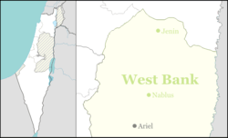
Hamra (Hebrew: חַמְרָה, lit. Red Soil) is a moshav and Israeli settlement in the West Bank.[2] Located in the Jordan Valley and covering 3,500 dunams, it falls under the jurisdiction of Bik'at HaYarden Regional Council.[2] In 2015 it had a population of 1,410. The international community considers Israeli settlements in the West Bank illegal under international law, but the Israeli government disputes this.[3]
History
The moshav was founded in 1971 and was initially named Atarot, before being renamed after nearby Tel Hamra.[2]
References
- ↑ "List of localities, in Alphabetical order" (PDF). Israel Central Bureau of Statistics. Retrieved 16 October 2016.
- 1 2 3 http://www.jordanvalley.org.il/page_49301
- ↑ "The Geneva Convention". BBC News. 10 December 2009. Retrieved 27 November 2010.
This article is issued from Wikipedia - version of the 9/6/2016. The text is available under the Creative Commons Attribution/Share Alike but additional terms may apply for the media files.