Hampton Double Square Historic District
|
Hampton Double Square Historic District | |
 | |
  | |
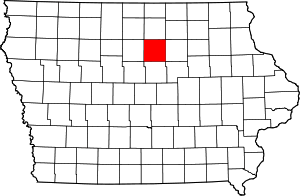
| Location | Roughly bounded by 2nd Ave., 1st Ave., the alley west of 1st St., and the alley east of Federal, Hampton, Iowa |
|---|---|
| Coordinates | 42°44′31″N 93°12′28″W / 42.74194°N 93.20778°WCoordinates: 42°44′31″N 93°12′28″W / 42.74194°N 93.20778°W |
| Architect |
Liebbe, Nourse & Rasmussen T.D. Allen |
| Architectural style | Italianate |
| NRHP Reference # | 03000834[1] |
| Added to NRHP | August 28, 2003 |
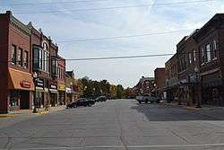
The Hampton Double Square Historic District is a historic district located in Hampton, Iowa, United States. The town of Hampton was laid out by H.P. Allen, who was the county surveyor, in June 1856. The original plat was eight blocks by eight blocks in the shape of an “L”. Near the center of the “L” was the two-block, or double, square. While many county seats in Iowa have a courthouse square, the double square is a rarity.[2] It exemplifies the two primary functions of a public square, both commercial and public development. It has been listed on the National Register of Historic Places since 2006.[1]
References
- 1 2 National Park Service (2010-07-09). "National Register Information System". National Register of Historic Places. National Park Service.
- ↑ Oltrogge, Sarah. "The Ely Community History Center". City of Ely. Retrieved 2012-06-02.
| Topics | |
|---|---|
| Lists by states |
|
| Lists by insular areas | |
| Lists by associated states | |
| Other areas | |
| |
This article is issued from Wikipedia - version of the 11/29/2016. The text is available under the Creative Commons Attribution/Share Alike but additional terms may apply for the media files.