Hammersbach
| Hammersbach | ||
|---|---|---|
| ||
 Hammersbach | ||
Location of Hammersbach within Main-Kinzig-Kreis district 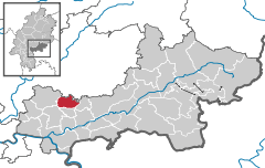
 | ||
| Coordinates: 50°13′N 08°59′E / 50.217°N 8.983°ECoordinates: 50°13′N 08°59′E / 50.217°N 8.983°E | ||
| Country | Germany | |
| State | Hesse | |
| Admin. region | Darmstadt | |
| District | Main-Kinzig-Kreis | |
| Government | ||
| • Mayor | Michael Göllner (SPD) | |
| Area | ||
| • Total | 20.15 km2 (7.78 sq mi) | |
| Population (2015-12-31)[1] | ||
| • Total | 4,797 | |
| • Density | 240/km2 (620/sq mi) | |
| Time zone | CET/CEST (UTC+1/+2) | |
| Postal codes | 63546 | |
| Dialling codes | 06185 | |
| Vehicle registration | MKK | |
| Website | www.hammersbach.de | |
.svg.png)
Hammersbach is a municipality in the district of Main-Kinzig-Kreis, in Hesse, Germany.
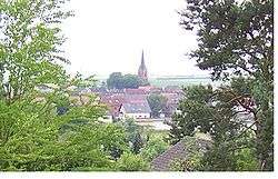
It is located near Frankfurt am Main. It consists of two districts: Marköbel and Langen-Bergheim. Only Marköbel once belonged to the Roman Empire. Parts of the Limes were found there recently. Since 2007 Hammersbach has an official connection to the motorway A45 that has been planned for a long time. Prior to that, it was necessary to use the Raststätte Langen-Bergheim to get access the motorway. There is a development area close to this motorway and within a few months some supermarkets and houses for families were built there. Hammersbach has many beautiful old houses in the center. The elementary school (Astrid-Lindgren-Schule) of Hammersbach can be seen easily from the fields around the village, because of the cone-shaped roof.

References
- ↑ "Bevölkerung der hessischen Gemeinden". Hessisches Statistisches Landesamt (in German). August 2016.